Three-dimensional geographic information visualization method and system based on video fusion

A geographic information and video fusion technology, applied in the field of geographic information systems, can solve the negative impact of the visualization process, screen tearing and other problems, to achieve the effect of ensuring accuracy and image perception

Active Publication Date: 2020-08-28
福建省伟志地理信息科学研究院
View PDF5 Cites 0 Cited by
  • Summary
  • Abstract
  • Description
  • Claims
  • Application Information

AI Technical Summary

Problems solved by technology

[0004] Most of the existing 3D geographic information visualization technologies use the method of frame-by-frame generation, which requires extremely strong hardware performance as support. If the hardware performance is insufficient or the hardware performance is degraded due to external factors, it will have a serious negative impact on the visualization process. Mainly manifested in screen tearing

Method used


Image

  • Three-dimensional geographic information visualization method and system based on video fusion

Examples


Embodiment Construction

[0038] The following will clearly and completely describe the technical solutions in the embodiments of the present invention with reference to the accompanying drawings in the embodiments of the present invention. Obviously, the described embodiments are only some, not all, embodiments of the present invention. Based on the embodiments of the present invention, all other embodiments obtained by persons of ordinary skill in the art without making creative efforts belong to the protection scope of the present invention.

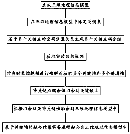
[0039] see figure 1 , figure 1 is a flow chart of the visualization method of the embodiment of the present invention.

[0040] A method for visualizing three-dimensional geographic information based on video fusion, comprising steps S1 to S8.

[0041] S1. Generate a three-dimensional geographic information model.

[0042] S2. Calibrating key points in the three-dimensional geographic information model. The 3D geographic information model is regarded as a ...


PUM


Abstract

The invention discloses a three-dimensional geographic information visualization method and system based on video fusion. The three-dimensional geographic information visualization method comprises the following steps: S1, generating a three-dimensional geographic information model; S2, calibrating key points in the three-dimensional geographic information model; S3, generating a plurality of keypoint coupling groups based on the spatial position relationship of the plurality of key points; S4, acquiring a real-time monitoring video; S5, performing frame analysis on the real-time monitoring video to obtain a plurality of key frames and a plurality of common frames; S6, fitting the key point coupling group to the key frame; S7, fusing the key frame into the three-dimensional geographic information model according to a fitting result; and S8, fusing the common frame into the three-dimensional geographic information model based on the fusion result of the key frame. According to the three-dimensional geographic information visualization method, hardware performance distribution is optimized in a priority division mode, and the accuracy of a three-dimensional geographic information visualization result and the impression of a picture are guaranteed.

Description

technical field [0001] The invention relates to the field of geographic information systems, in particular to a method and system for visualizing three-dimensional geographic information based on video fusion. Background technique [0002] Geographical information data visualization is mainly based on geographic information science, computer science, cartography, cognitive science, information transmission science and geographic information system, and through computer technology, digital technology, multimedia technology, dynamic, intuitive and vivid performance and interpretation , Transmitting geographic information and spatial information and revealing its laws, is a discipline about the theory, method and technology of information expression and transmission. It aims to display and interact with the results and data of geoscience information input, processing, query, analysis and prediction in graphical symbols, icons, text, tables, videos and other visual forms by mean...

Claims


Application Information

Patent Timeline
Patent Type & Authority Applications(China)
IPC IPC(8): G06F16/29
CPCG06F16/29
Inventor 陈志谋
Owner 福建省伟志地理信息科学研究院
Why Eureka
Try Eureka