Remote sensing cultivated land change detection method based on object map and mixed spectrum

A hybrid spectrum, change detection technology, applied in character and pattern recognition, instrument, scene recognition and other directions, can solve the problem of low detection accuracy, and achieve the effect of improving detection accuracy, improving accuracy and good adaptability

Active Publication Date: 2020-08-28
INST OF GEOGRAPHICAL SCI & NATURAL RESOURCE RES CAS
View PDF7 Cites 12 Cited by
  • Summary
  • Abstract
  • Description
  • Claims
  • Application Information

AI Technical Summary

Problems solved by technology

[0013] The purpose of the present invention is to provide a remote sensing cultivated land change detection

Method used


Image

  • Remote sensing cultivated land change detection method based on object map and mixed spectrum
  • Remote sensing cultivated land change detection method based on object map and mixed spectrum
  • Remote sensing cultivated land change detection method based on object map and mixed spectrum

Examples


Embodiment Construction

[0045] The technical solutions in the embodiments of the present invention will be clearly and completely described below, obviously, the described embodiments are only some of the embodiments of the present invention, not all of the embodiments. All other embodiments obtained by persons of ordinary skill in the art based on the embodiments of the present invention belong to the protection scope of the present invention.

[0046] The present invention will be described in detail below with reference to the accompanying drawings and examples. It should be noted that, in the case of no conflict, the embodiments of the present invention and the features in the embodiments can be combined with each other.

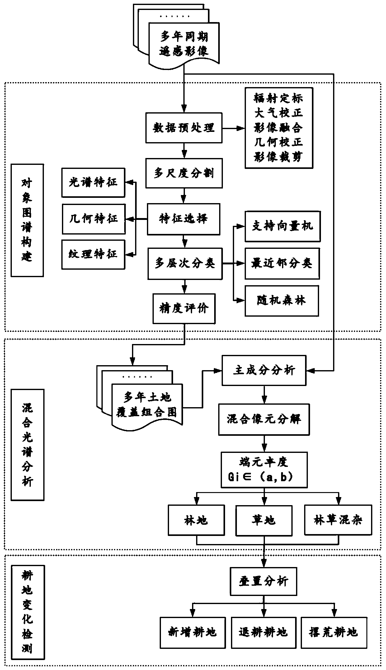
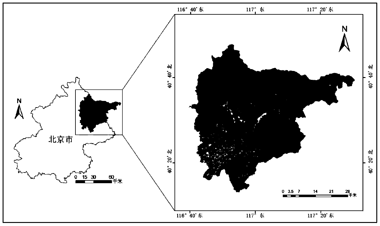
[0047] In the present invention, based on my country's existing land cover / land use classification system, referring to the classification system of "China's 1:1 million land use map" under the system of the Chinese Academy of Sciences, the land use types are divided into cultiva...


PUM


Abstract

The invention provides a remote sensing cultivated land change detection method based on an object map and a mixed spectrum. The remote sensing cultivated land change detection method comprises the following steps: step 1, acquiring synchronous remote sensing image data of at least five years; step 2, constructing an object map of the image according to the remote sensing image data; wherein the construction process comprises data preprocessing, image segmentation, feature extraction and image classification; step 3, performing mixed spectrum analysis on the object spectrum; and step 4, detecting the change of the cultivated land through superposition analysis. According to the invention, the difference characteristics of a cultivated land object map and the differentiation characteristicsof mixed spectrum calculation are combined; a corresponding knowledge rule structure is established according to the evolution characteristics of the cultivated land change type, the change of the cultivated land and other ground object types in the change process is described, the detection precision of cultivated land change details is improved, the precision of the whole remote sensing cultivated land change detection method is further improved, and the adaptability of the new detection method is better.

Description

technical field [0001] The invention belongs to the technical field of remote sensing image detection, and in particular relates to a remote sensing cultivated land change detection method based on an object map and a mixed spectrum. Background technique [0002] With the rapid economic development, increased pollution, population growth and many other reasons, the world is facing food security issues such as the reduction of cultivated land and the decline of soil quality. Therefore, protecting cultivated land is an important task in the process of promoting the realization of food security; then, can Efficient and accurate detection and grasp of changes in cultivated land conditions will have important guiding significance for the precise control of changes in land resource types and land resource development planning. [0003] Traditional cultivated land change detection relies on cultivated land monitoring. This method has problems such as heavy workload, high cost, long...

Claims


Application Information

Patent Timeline
IPC IPC(8): G06K9/00G06K9/32G06K9/34G06K9/46G06K9/62
CPCG06V20/194G06V20/188G06V20/13G06V10/25G06V10/267G06V10/56G06F2218/00G06F2218/12G06F18/24323
Inventor 王勇杨玉
Owner INST OF GEOGRAPHICAL SCI & NATURAL RESOURCE RES CAS
Why Eureka
Try Eureka