Tidal zone surveying and mapping method and device based on semantic segmentation

A semantic segmentation and tidal technology, applied in surveying and navigation, surveying devices, surveying instruments, etc., can solve problems such as insufficient tidal zone data sets, blurred boundary pixels, etc., achieve high capacity and flexibility, high flexibility, and improve surveying and mapping efficiency effect

Active Publication Date: 2020-09-15
UNIV OF ELECTRONICS SCI & TECH OF CHINA
View PDF8 Cites 2 Cited by
  • Summary
  • Abstract
  • Description
  • Claims
  • Application Information

AI Technical Summary

Problems solved by technology

Current classification methods usually rely on features obtained from image segmentation, from shape, color or texture. Semantic segmentation classification methods based on convolutional neural networks have better generalization ability than traditional methods, but even so, there are still boundaries For the problem of blurred pixels and insufficient tidal zone data sets, for the accuracy of boundary recognition, the gradient-based histogram threshold (GHT) is combined to further utilize the boundary line features of the tidal zone segmentation model

Method used


Image

  • Tidal zone surveying and mapping method and device based on semantic segmentation
  • Tidal zone surveying and mapping method and device based on semantic segmentation
  • Tidal zone surveying and mapping method and device based on semantic segmentation

Examples


Embodiment 1

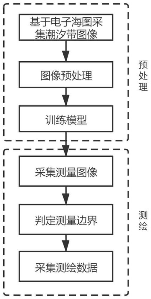
[0044] Such as figure 1 As shown, a tidal zone mapping method based on semantic segmentation includes the following steps:

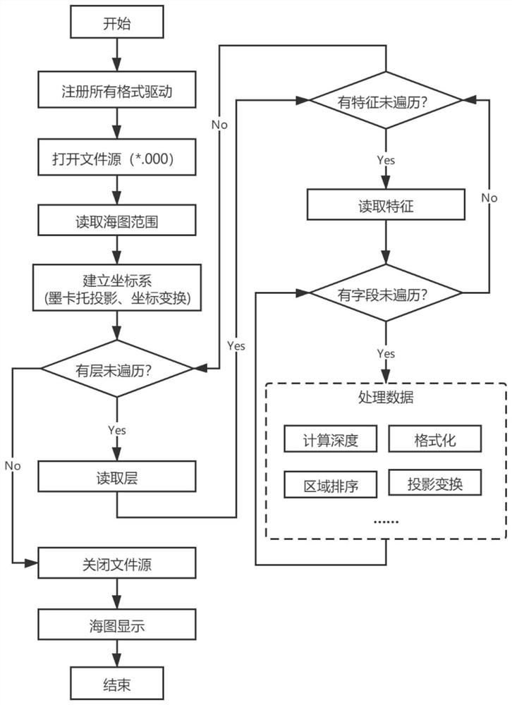
[0045] Step one, such as image 3 , use OGR to realize chart data reading, open the file source after registering all the drivers, read into the 0th layer to obtain the latitude and longitude range of the chart, perform Mercator projection and coordinate transformation on the boundary latitude and longitude to establish the plane coordinate system of the chart; and then Judge whether the traversal is completed layer by layer, feature by feature, and field by field, and read and process chart data field by field;

[0046] Then, a large number of original acquisition images are collected according to the tidal zone position data provided by the S-57 electronic chart. Segmented images are accurately calibrated to form a training set;

[0047] Specifically, the acquisition method of the uncalibrated segmented image: the original acquisition image is randoml...

Embodiment 2

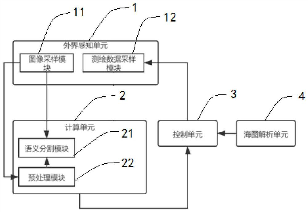
[0068] Such as figure 2 As shown, a tidal zone surveying and mapping device based on semantic segmentation includes an external perception unit 1, a calculation unit 2, a control unit 3, and a chart analysis unit 4; the external perception unit 1 outputs image information to the calculation unit 2, and the calculation unit 2 according to The image information calculates the pre-travel route of the surveying and mapping equipment and outputs it to the control unit 3, the chart analysis unit 4 reads the S-57 standard electronic chart and outputs the basic environmental information to the control unit 3, and the control unit 3 outputs control signals to the external perception unit 1 ;

[0069] The external perception unit 1 includes an image sampling module 11 and a surveying and mapping data sampling module 12; the image sampling module is used to obtain image information 11; the control unit 3 outputs a control signal to control the surveying and mapping data sampling module ...


PUM


Abstract

The invention discloses a tidal zone surveying and mapping method and device based on semantic segmentation, being characterized in that a semantic segmentation adversarial network composed of a segmentation model and an adversarial network is adopted; before the tidal zone is accurately surveyed and mapped, the tidal zone is automatically identified and divided by utilizing an acquired image based on semantic segmentation, so that the surveying and mapping efficiency is improved; and characteristics of high capacity and high flexibility of the adversarial model are utilized, and semi-supervised learning can be carried out, and matching of a lot of high-order statistical information between model prediction and calibration results is detected, and manual definition of all samples is not needed.

Description

technical field [0001] The invention relates to the technical field of surveying and mapping equipment, in particular to a tidal zone surveying and mapping method and equipment based on semantic segmentation. Background technique [0002] The tidal zone refers to the narrow and long area that is repeatedly in the alternate environment of sea and land with the ebb and flow of the tide. The tidal zone is different from other tidal zone objects and land objects. Due to its special geographical properties, it is complex and changeable. With the development of navigation technology and the increase of demand, such as the development of automatic navigation technology of underwater drones, the improvement Tidal zone mapping data update frequency becomes necessary. In addition, as the coastal tourism industry is becoming more and more popular, maintaining a high frequency of tidal zone surveying and mapping can also ensure the safety of tourists. Smart tidal zone surveying and ma...

Claims


Application Information

Patent Timeline
Patent Type & Authority Applications(China)
IPC IPC(8): G06K9/46G06K9/34G06K9/62G06K9/00G01C15/00
CPCG01C15/00G06V20/588G06V10/267G06V10/44G06F18/23213G06F18/214
Inventor 彭倍吕文薪魏敦文王刚代小林
Owner UNIV OF ELECTRONICS SCI & TECH OF CHINA
Why Eureka
Try Eureka