Calculation method of subsatellite points and photographic point trajectory self-intersection points of near-earth regression orbit satellite

A technology of return orbit and calculation method, which is applied in the field of remote sensing satellites, and can solve problems such as easy loss, large amount of calculation, and long intervals of adjacent observations

Active Publication Date: 2020-09-18
BEIHANG UNIV
View PDF2 Cites 11 Cited by
  • Summary
  • Abstract
  • Description
  • Claims
  • Application Information

AI Technical Summary

Problems solved by technology

[0004] Traditional near-Earth satellites often use sun-synchronous orbits for earth observation. Although regular revisit observations of designated points on the ground are realized, there are still observatio

Method used


Image

  • Calculation method of subsatellite points and photographic point trajectory self-intersection points of near-earth regression orbit satellite
  • Calculation method of subsatellite points and photographic point trajectory self-intersection points of near-earth regression orbit satellite
  • Calculation method of subsatellite points and photographic point trajectory self-intersection points of near-earth regression orbit satellite

Examples


Embodiment 1

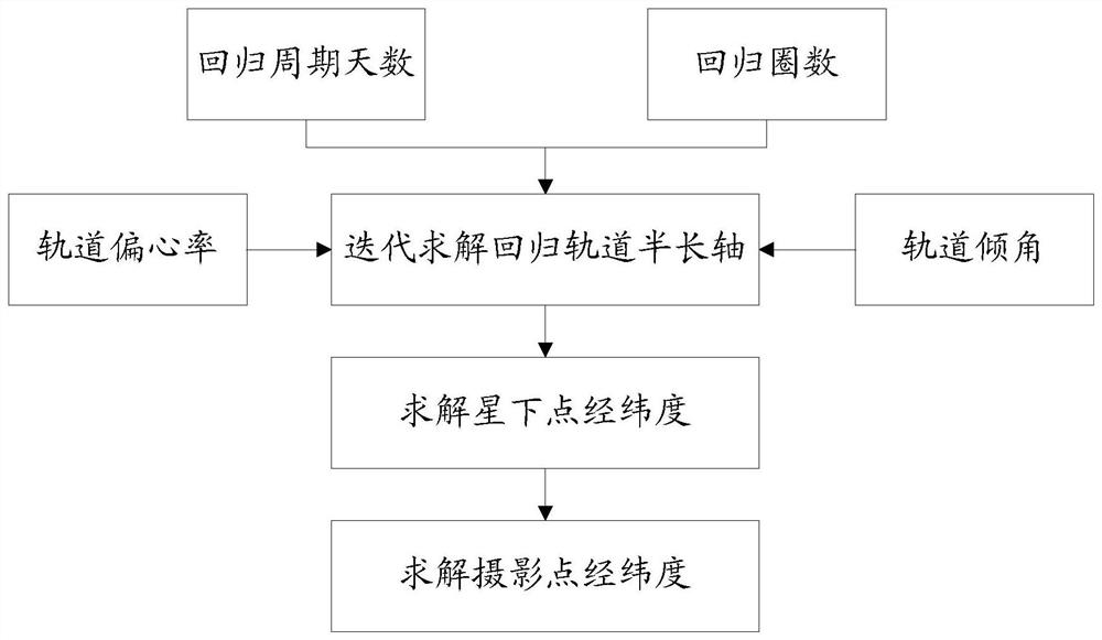
[0097] Such as figure 1 , in this embodiment, the calculation method of the sub-satellite point of the low-Earth orbit satellite and the self-intersection point of the photographic point track includes:

[0098] Step 101, iteratively solve the semi-major axis of the regression orbit according to the orbit inclination, the orbit eccentricity, the number of days of the regression cycle and the number of regression cycles.

[0099] In this embodiment, the specific solution process of the semi-major axis of the regression orbit can be as follows:

[0100] a) Select orbital eccentricity e, orbital inclination i, return period days D and return circles N.

[0101] First, select the orbital eccentricity e and orbital inclination i.

[0102] Then, according to the selected orbital eccentricity e and orbital inclination i, the earth flattening perturbation coefficient J 2 The following orbital parameters:

[0103]

[0104]

[0105]

[0106] Among them, Ω represents the rig...

Embodiment 2

[0175] On the basis of the above-mentioned embodiment, the following will be described in conjunction with an example.

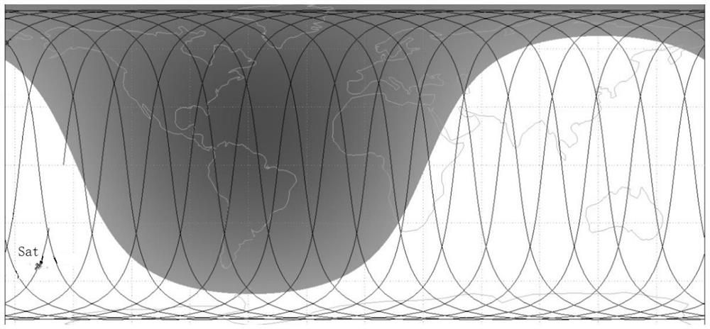
[0176] In this embodiment, the trajectories of sub-satellite points and photographic points are as follows image 3 and Figure 4 As shown, the central part of the trajectory is the sub-satellite point trajectory, and the side trajectory is the photography point trajectory. The central area and boundary range of the coverage can be determined by the self-intersection points formed by the sub-satellite point trajectory and the photography point trajectory respectively.

[0177] The specific calculation steps are as follows:

[0178] (1) Select the following parameters: e=0, i=94 °; estimate D=3, N=29 according to the initial value of the orbital height; set J 2 The drift rates of ascending node right ascension, argument of perigee and true anomaly under perturbation are expressed as a function of the semi-major axis of the regression orbit.

[0179] In ord...


PUM


Abstract

The invention discloses a calculation method of subsatellite points and photographic point trajectory self-intersection points of a near-earth regression orbit satellite. Based on an orbital perturbation model of the earth oblateness (J2), the mean influence of the earth oblateness on the long-term perturbation of the right ascension of the ascending node, the perigee argument and the aplanatic angle is utilized, so that the mean drift period and the orbital intersection period of the satellite orbital plane relative to the earth resonate, and revisit regression of the orbital relative to thesubsatellite point and the photographic point trajectory of the earth surface is formed. After the orbit inclination angle, the eccentricity ratio, the regression days and the period number are given,the orbit semi-major axis can be solved, then the longitude of the sub-satellite point trajectory self-intersection point is analyzed and solved, the latitude of the self-intersection point under thecorresponding precision is screened out through numerical screening, and the distribution situation of the sub-satellite point trajectory self-intersection point in one regression period can be obtained. The invention provides a practical near-earth regression orbit sub-satellite point trajectory self-intersection point calculation method, and the method has important application value in near-earth surveying and mapping, remote sensing, reconnaissance, InSAR and other regression orbit satellite measurement tasks.

Description

technical field [0001] The invention belongs to the technical field of remote sensing satellites, and in particular relates to a method for calculating the self-intersection point of sub-satellite points and photographic point tracks of low-Earth return orbit satellites. Background technique [0002] According to mission requirements, remote sensing satellites often need to make repeated observations of specific areas within a certain period of time to complete tasks such as ground imaging and 3D terrain modeling, and regular revisit and regression detection is required for key areas of concern. The low-Earth return orbit is generally used to realize this function, which has the advantages of low cost, good imaging effect, short revisit time, dense sub-satellite points, and wide detection range. [0003] Due to the perturbation of the Earth's non-spherical gravitational force (especially the J 2 item) is more obvious, it will cause a large drift of the satellite orbit in th...

Claims


Application Information

Patent Timeline
IPC IPC(8): G06F30/15
CPCG06F30/15
Inventor 徐明郭东辉潘晓姚闯李庆龙和星吉
Owner BEIHANG UNIV
Why Eureka
Try Eureka