Water environment remote sensing data modeling method based on multilayer convolutional neural network

A convolutional neural network and remote sensing data technology, which is applied in the field of water environment remote sensing data modeling based on multi-layer convolutional neural networks, can solve the problems of time-consuming, inability to perform real-time monitoring, and inability to fully reflect the overall temporal and spatial changes of the water ecological environment. , to reduce the complexity

Inactive Publication Date: 2020-09-18
CHONGQING UNIV
View PDF9 Cites 3 Cited by
  • Summary
  • Abstract
  • Description
  • Claims
  • Application Information

AI Technical Summary

Problems solved by technology

[0002] Traditional water quality monitoring uses methods such as on-site sampling and laboratory analysis. This type of monitoring method has certain accuracy, but it is carried out at a point, which cannot fully reflect the overall temporal and spatial changes of the water ecological environment, and is time-consuming, laborious, and expensive. The cost is high, and more importantly, real-time monitoring cannot be performed

Method used


Image

  • Water environment remote sensing data modeling method based on multilayer convolutional neural network
  • Water environment remote sensing data modeling method based on multilayer convolutional neural network
  • Water environment remote sensing data modeling method based on multilayer convolutional neural network

Examples


Embodiment 1

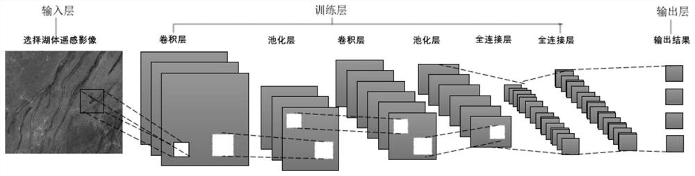
[0032] Such as Figure 1-4 As shown, the HJ-1A / B satellite was successfully launched at 11:25 am on September 6, 2008. The design principles of the two CCD cameras mounted on the two satellites are exactly the same, and can generate push-broom imaging in four spectral bands , the ground swath width is 700 kilometers, the ground pixel resolution is 30 meters, and the revisit period after the two CCD cameras are networked is only 2 days, and the transit time of Changshou Lake is about 10-11a.m. From March 2015 to October 2018, 157 remote sensing images were actually acquired. During the field sampling period, the HJ-1 / CCD remote sensing images, the lake area is 66km2, and one image can cover it.

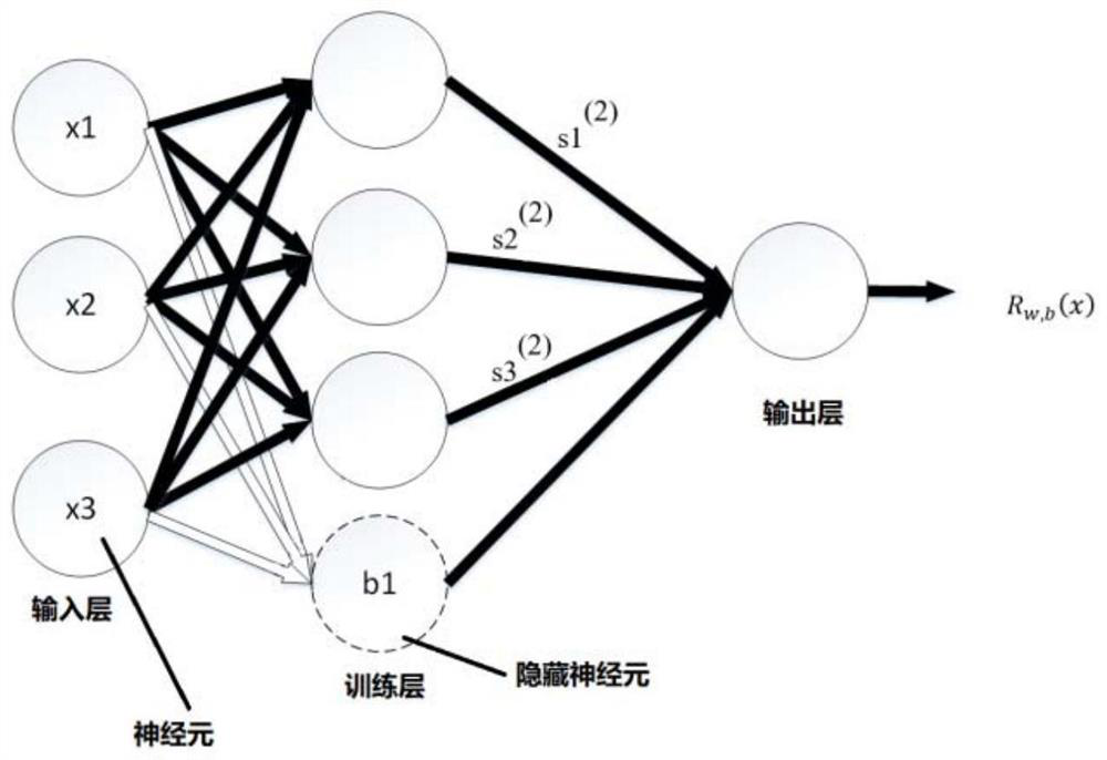
[0033] Before using the multi-layer convolutional neural network algorithm to train the image, the image is preprocessed such as normalization, and the data is mapped to the activation function value range (0,1) of the output layer. Due to the difficulty in obtaining remote sensing im...

Embodiment 2

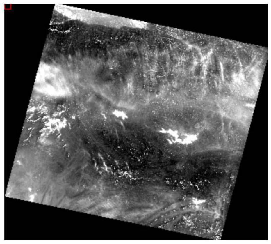
[0036] Such as Figure 5 As shown in the figure, it shows the change of water eutrophication in a remote sensing image of Changshou Lake in different periods in 2018. It can be seen from the figure that the data presented after the convolution layer of the remote sensing image can be displayed more clearly and intuitively . In the figure, the chlorophyll concentration of the water body began to increase in April and reached its peak in July. This is consistent with the measured results. Therefore, after repeated trials and comparisons, the convolutional neural network algorithm for water environment remote sensing based on multi-layer convolutional neural networks can extract remote sensing information more accurately, and can basically meet the requirements of automatic inversion of water quality status.


PUM


Abstract

The invention belongs to the technical field of water environment remote sensing data analysis, and particularly relates to a water environment remote sensing data modeling method based on a multilayer convolutional neural network, and a data model is formed by sequentially connecting an input layer, a training layer and an output layer; the input of the input layer is preprocessed remote sensingimage data; the training layer comprises a convolution layer, a pooling layer and a full connection layer; each of the convolution layer, the pooling layer and the full connection layer is composed ofa plurality of hidden neurons with mutually independent matrixes; the output layer is used for outputting results, the training layer learns and inputs high-level features through layer-by-layer feature extraction of a remote sensing spectral feature curve of remote sensing image data acquired by a preprocessed satellite, and inputs the high-level features into the full connection layer to identify a result; and the large-scale water environment online remote sensing water quality accurate identification and diagnosis system aims to realize large-scale water environment online remote sensingwater quality accurate identification and diagnosis of the three gorges reservoir area so as to provide a reliable and easy-to-use large-scale water environment monitoring and auxiliary decision-making tool.

Description

technical field [0001] The invention belongs to the technical field of water environment remote sensing data analysis, and in particular relates to a water environment remote sensing data modeling method based on a multi-layer convolutional neural network. Background technique [0002] Traditional water quality monitoring uses methods such as on-site sampling and laboratory analysis. This type of monitoring method has certain accuracy, but it is carried out at a point, which cannot fully reflect the overall temporal and spatial changes of the water ecological environment, and is time-consuming, laborious, and expensive. The cost is high, and more importantly, real-time monitoring cannot be performed. Remote sensing water quality monitoring combined with in-situ monitoring technology has remarkable characteristics such as macroscopic, dynamic, and low cost. Its application in water quality monitoring has irreplaceable advantages of conventional monitoring. It can not only me...

Claims


Application Information

Patent Timeline
Patent Type & Authority Applications(China)
IPC IPC(8): G06K9/00G06K9/46G06K9/62G06N3/04G06N3/08
CPCG06N3/084G06V20/13G06V10/462G06N3/045G06F18/24
Inventor 封雷方芳郭劲松封丽余由
Owner CHONGQING UNIV
Why Eureka
Try Eureka