Ultrahigh-precision positioning sensor combining GPS positioning with panoramic imaging map matching

A GPS positioning and positioning sensor technology, applied in the field of precise navigation, can solve the problems of low positioning accuracy, difficulty in rapid response of unmanned driving, and difficult application of unmanned driving, etc., to achieve the effect of reducing distortion and high precision

Pending Publication Date: 2020-09-29
NANJING UNIV OF SCI & TECH
View PDF6 Cites 0 Cited by
  • Summary
  • Abstract
  • Description
  • Claims
  • Application Information

AI Technical Summary

Problems solved by technology

The current positioning and navigation systems mainly include GPS navigation, Beidou satellite navigation, etc., which provide users with real-time location and navigation information through satellites, but this type of positioning system has a low positioning accuracy of about 0.5-1m, which is difficult to apply to wireless Quick response to human driving; at the same time, today's navigation systems rely on radio signals for signal transmission, which cannot be used in some areas without radio, such as tunnels, so it is difficult to apply to unmanned driving

Method used


Image

  • Ultrahigh-precision positioning sensor combining GPS positioning with panoramic imaging map matching
  • Ultrahigh-precision positioning sensor combining GPS positioning with panoramic imaging map matching

Examples


Embodiment Construction

[0011] The present invention will be further introduced below in conjunction with the accompanying drawings and specific embodiments.

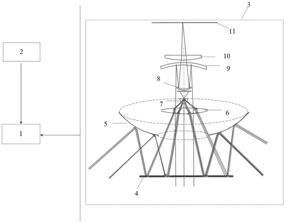
[0012] to combine figure 1 , a kind of GPS positioning of the present invention combines the ultra-high-precision positioning sensor of panoramic imaging map matching, comprises DSP on-chip signal processing unit 1, GPS positioning module 2 and panoramic imaging assembly 3;

[0013] The panoramic imaging assembly 3 is followed by a convex mirror 5, a dichroic mirror 4, a biconvex lens 6, a fisheye lens 7, a meniscus positive lens 8, a meniscus negative lens 9, a focusing lens 10, and an imaging screen 11 along the optical path. The optical axis of described convex reflector 5, dichroic mirror 4, biconvex lens 6, meniscus positive lens 8, meniscus negative lens 9 and focusing lens 10 is all on the optical axis of fisheye lens 7 imaging; The GPS positioning module 2 is used to provide accurate marker orientation to the DSP on-chip signal proces...


PUM


Abstract

The invention discloses an ultrahigh-precision positioning sensor combining GPS positioning with panoramic imaging map matching. The ultrahigh-precision positioning sensor comprises a signal processing unit, a GPS positioning module and a panoramic imaging assembly. The panoramic imaging assembly sequentially comprises a convex reflector mirror, a dichroic mirror, a biconvex lens, a fisheye lens,a meniscus positive lens, a meniscus negative lens, a focusing lens and an imaging screen in the light path direction. The optical axes of the convex reflector, the dichroic mirror, the biconvex lens,the meniscus positive lens, the meniscus negative lens and the focusing lens are all on the optical axis of fisheye lens imaging. The GPS positioning module is used for providing an accurate marker orientation for the signal processing unit; the signal processing unit is used for processing an image of the panoramic imaging assembly, receiving a GPS big data map, acquiring accurate coordinates ofthe marker by using a GPS positioning system, and inverting the position of the panoramic lens by using coordinate information of the target object so as to accurately obtain real-time coordinates ofthe moving object. The positioning precision can be improved.

Description

technical field [0001] The invention belongs to the technical field of precise navigation, in particular to an ultra-high-precision positioning sensor combined with GPS positioning and panoramic imaging map matching. Background technique [0002] At present, intelligent transportation is booming, and unmanned driving technology has become a research hotspot, which has also promoted the continuous development of positioning and navigation technology. The current positioning and navigation systems mainly include GPS navigation, Beidou satellite navigation, etc., which provide users with real-time location and navigation information through satellites, but this type of positioning system has a low positioning accuracy of about 0.5-1m, which is difficult to apply to wireless Quick response of human driving; at the same time, today's navigation systems rely on radio signals for signal transmission, which cannot be used in some areas without radio, such as tunnels, so it is diffic...

Claims


Application Information

Patent Timeline
Patent Type & Authority Applications(China)
IPC IPC(8): G01S19/45
CPCG01S19/45
Inventor 许文进赵楚航陶洁雨来建成黄宏坤李振华
Owner NANJING UNIV OF SCI & TECH
Why Eureka
Try Eureka