Satellite image adjustment method and device based on plane constraint optimization virtual control points

A technology of virtual control points and satellite images, which is used in measurement devices, image enhancement, image analysis, etc., can solve the problems of low accuracy of virtual control points and no significant improvement in plane direction accuracy, and achieve the effect of eliminating inconsistency and improving efficiency.

Active Publication Date: 2020-09-29
TONGJI UNIV
View PDF6 Cites 5 Cited by
  • Summary
  • Abstract
  • Description
  • Claims
  • Application Information

AI Technical Summary

Problems solved by technology

[0004] To sum up, in order to improve the accuracy of uncontrolled adjustment of high-resolution optical satellite images, some studies have used initial files to generate regular grid virtual control points, without considering the influence of terrain factors an

Method used


Image

  • Satellite image adjustment method and device based on plane constraint optimization virtual control points
  • Satellite image adjustment method and device based on plane constraint optimization virtual control points
  • Satellite image adjustment method and device based on plane constraint optimization virtual control points

Examples


Embodiment 1

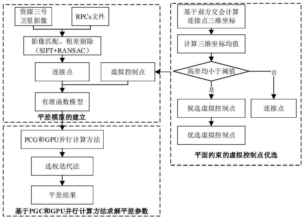
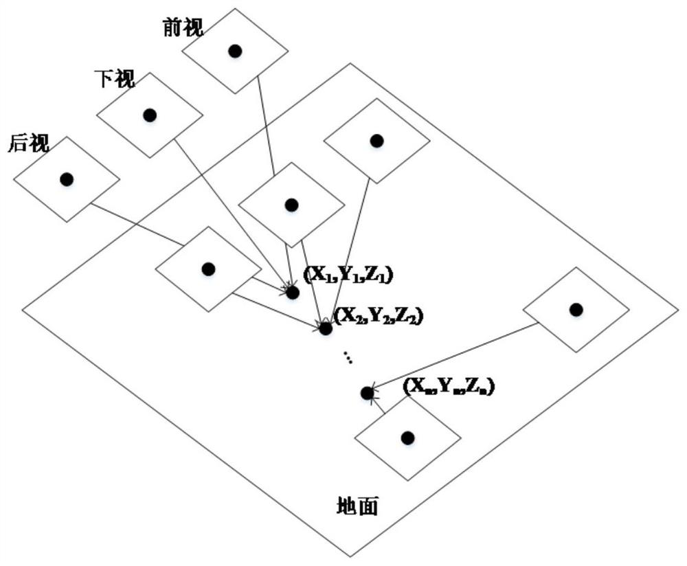
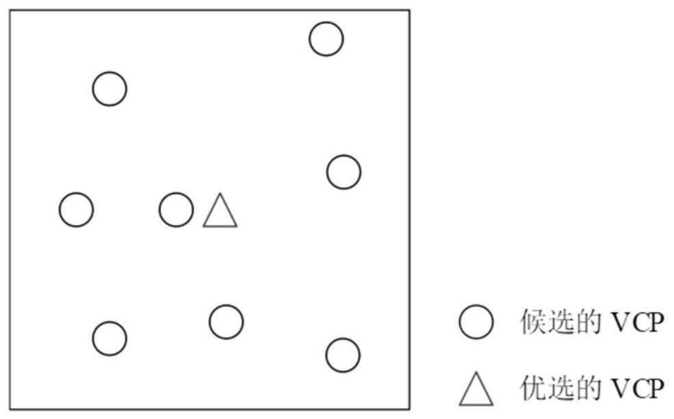
[0046] Uncontrolled block adjustment of high-resolution satellite images is one of the key technologies for global mapping applications. In the uncontrolled block adjustment of high-resolution optical satellite images, the selection of virtual control points is an important factor to determine the accuracy of the adjustment. To solve the problem of uncontrolled block network adjustment accuracy, the traditional virtual control point is a regular grid method generated by the initial RPC file, which does not consider the influence of terrain factors, which may reduce the adjustment accuracy. In order to further improve the accuracy of uncontrolled block network adjustment, this embodiment proposes a satellite image adjustment method based on plane constraints to select virtual control points, so as to ensure that the virtual control points are located in areas with small elevation differences as much as possible. The method is mainly composed of the following three parts: 1) cal...


PUM


Abstract

The invention relates to a satellite image adjustment method and device based on plane constraint optimization virtual control points, and the method comprises the following steps: carrying out the image matching and gross error elimination according to a satellite image and a corresponding RPC file, and obtaining a connection point; constructing a plurality of three-dimensional image models, andcalculating ground three-dimensional coordinates of each connection point by utilizing spatial forward intersection in each three-dimensional image model; calculating the height difference of each connection point in different three-dimensional image models, and taking the connection points of which the height differences in the different three-dimensional image models are smaller than a preset height difference threshold value as virtual control points, the height difference being the difference between the elevation of the connection point in the different three-dimensional image models andthe elevation mean value of the connection point; and partitioning the three-dimensional image model, selecting an optimal virtual control point in each block, and carrying out satellite image adjustment. Compared with the prior art, topographic factors are considered when the virtual control points are selected, plane constraints are increased, and adjustment precision and efficiency are improved.

Description

technical field [0001] The invention relates to the field of satellite image adjustment, in particular to a satellite image adjustment method and device for optimizing virtual control points based on plane constraints. Background technique [0002] High-precision geometric positioning of high-resolution satellite imagery often requires reliable control information. The commonly used method is to invert the geometric relationship between the image space and the ground space coordinate system by using uniformly distributed obvious ground object points. Therefore, obtaining enough high-precision ground control points (GCP) is the key to ensure the geometric positioning accuracy and accuracy of satellite images. One of the important prerequisites for reliability. However, the measurement of high-precision ground control points is often time-consuming and laborious. In some areas, such as overseas, deserts, and dense forests, it is often difficult or even impossible to obtain co...

Claims


Application Information

Patent Timeline
IPC IPC(8): G06T17/00G06T7/70G06F17/15G01C11/00
CPCG06T17/00G06F17/15G06T7/70G01C11/00G06T2207/10032Y02T10/40
Inventor 童小华刘世杰付青王瀚渔金雁敏许雄王超柳思聪
Owner TONGJI UNIV
Why Eureka
Try Eureka