Satellite visibility judgment method combined with terrain influence

A satellite and terrain technology, applied in satellite radio beacon positioning systems, measuring devices, instruments, etc., can solve the problems of reduced number of visible satellites, obstruction of satellite signals, low positioning standards, etc.

Pending Publication Date: 2020-10-27
NANJING FORESTRY UNIV
View PDF5 Cites 3 Cited by
  • Summary
  • Abstract
  • Description
  • Claims
  • Application Information

AI Technical Summary

Problems solved by technology

[0002] In GPS positioning, multiple satellites are required to cover the survey area to obtain better measurement results. However, in actual work, the number of visible satellites is often reduced due to the influence of terrain.
For example, the diversity of mountainous terrain and the influence of urban buildings make satellite signals blocked by tall buildings, ov...

Method used


Image

  • Satellite visibility judgment method combined with terrain influence
  • Satellite visibility judgment method combined with terrain influence
  • Satellite visibility judgment method combined with terrain influence

Examples


Embodiment

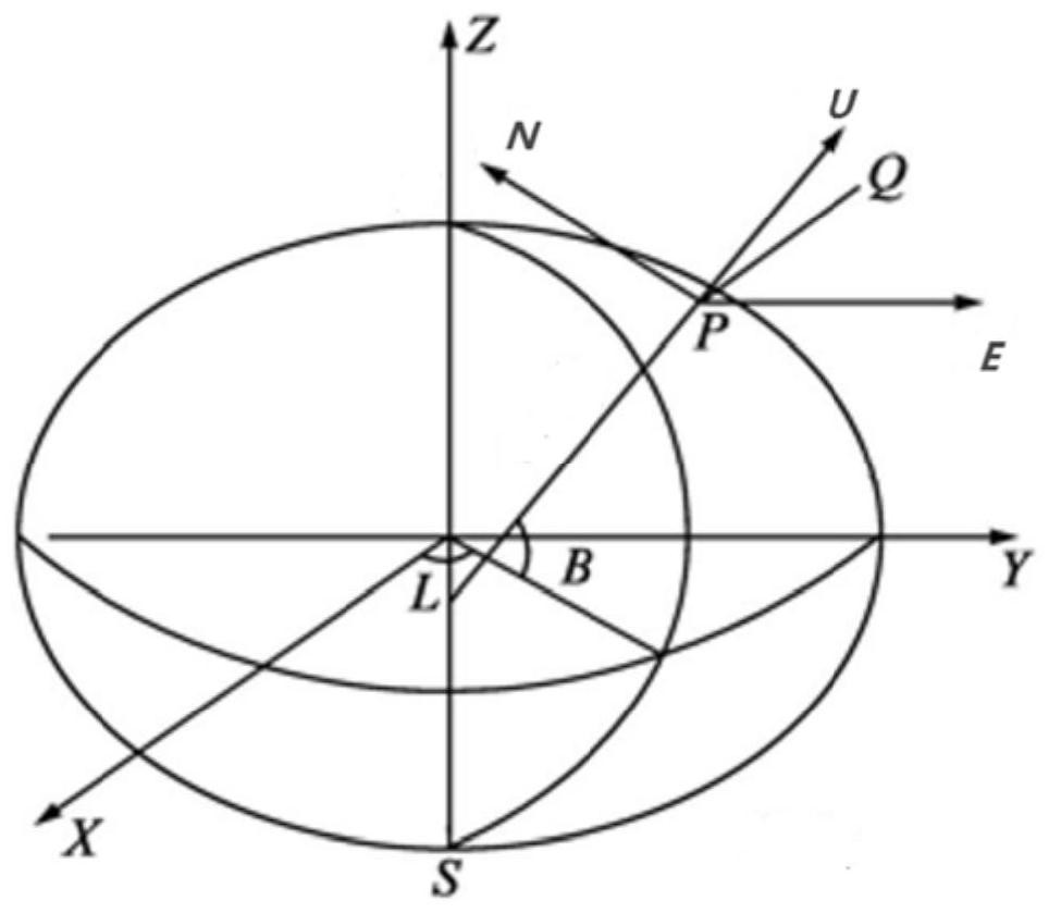
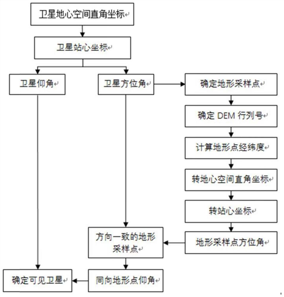
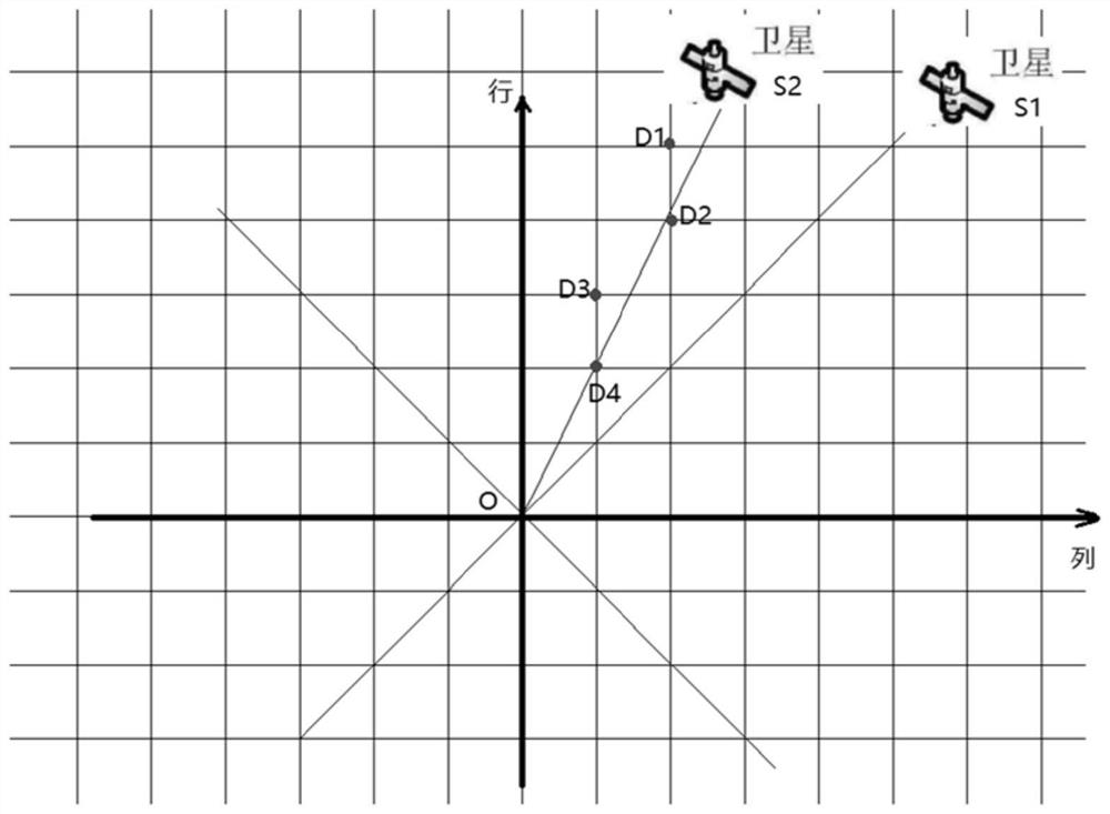
[0061] This embodiment provides a satellite visibility judgment method combined with the influence of terrain. First, select the experimental area, select a point in the experimental area as the observation point, and determine the observation time. The algorithm uses the satellite coordinates and the position coordinates of the observation point to judge For satellite visibility in this area, first calculate the elevation angle and azimuth angle of the satellite, and then use the calculation results to judge the visibility of the satellite; secondly, introduce the influence of terrain, recalculate the elevation angle, judge the satellite visibility again and make a comparison.

[0062] The steps of directly judging the satellite visibility through the satellite elevation angle are: (1) normalize the coordinates of the satellite geocentric coordinate system to the station center coordinate system with the station as the origin; (2) calculate the satellite elevation angle and azim...


PUM


Abstract

The invention discloses a satellite visibility judgment method combined with terrain influence. The method comprises the following steps of step 1, selecting an observation area, determining a stationpoint, calculating a satellite elevation angle by utilizing satellite coordinates and position coordinates of the station point, and judging the visibility of a satellite in the observation area; andstep 2, introducing topographic influence, calculating elevation angles of topographic sampling points, performing comparative analysis with elevation angles of satellites, and judging the visibilityof satellites again. The method is advantaged in that after terrain shielding of the experimental area is considered, the number of visible satellites and positioning accuracy of the satellites are obviously reduced compared with those when terrain shielding is not considered.

Description

technical field [0001] The invention relates to a method for judging satellite visibility combined with terrain effects. Background technique [0002] In GPS positioning, multiple satellites are required to cover the survey area to obtain better measurement results. However, in actual work, the number of visible satellites is often reduced due to the influence of terrain. For example, the diversity of mountainous terrain and the influence of urban buildings make satellite signals blocked by tall buildings, overpasses, and natural terrain, resulting in a significant reduction in the number of visible satellites, and even the number of satellites cannot meet the minimum positioning standards. However, most satellite visibility analyzes ignore the influence of these factors, resulting in a large difference between the satellite visibility evaluation results and the actual situation. Contents of the invention [0003] Purpose of the invention: In order to more accurately eval...

Claims


Application Information

Patent Timeline
IPC IPC(8): G01S19/20G01C1/00
CPCG01S19/20G01C1/00
Inventor 隋铭明沈飞杨易
Owner NANJING FORESTRY UNIV
Why Eureka
Try Eureka