
Method for automatically measuring coordinates of target point of fully mechanized coal mining face and measuring robot system

A fully-mechanized mining face and automatic measurement technology, applied in the computer field, can solve problems such as geological model coupling, and achieve the effects of unmanned, good promotion value, and reasonable design

Active Publication Date: 2020-10-30
BEIZHING LONGRUAN TEKNOLODZHIS INK
View PDF4 Cites 10 Cited by
  • Summary
  • Abstract
  • Description
  • Claims
  • Application Information

AI Technical Summary

Problems solved by technology

At present, the coordinates based on the combined positioning of inertial navigation and odometer are relative coordinates, which cannot be coupled with geological models

Method used


Image

  • Method for automatically measuring coordinates of target point of fully mechanized coal mining face and measuring robot system
  • Method for automatically measuring coordinates of target point of fully mechanized coal mining face and measuring robot system
  • Method for automatically measuring coordinates of target point of fully mechanized coal mining face and measuring robot system

Examples


Embodiment Construction

[0042] In order to make the above objectives, features and advantages of the present invention more obvious and understandable, the present invention will be further described in detail below in conjunction with the accompanying drawings and specific implementations.

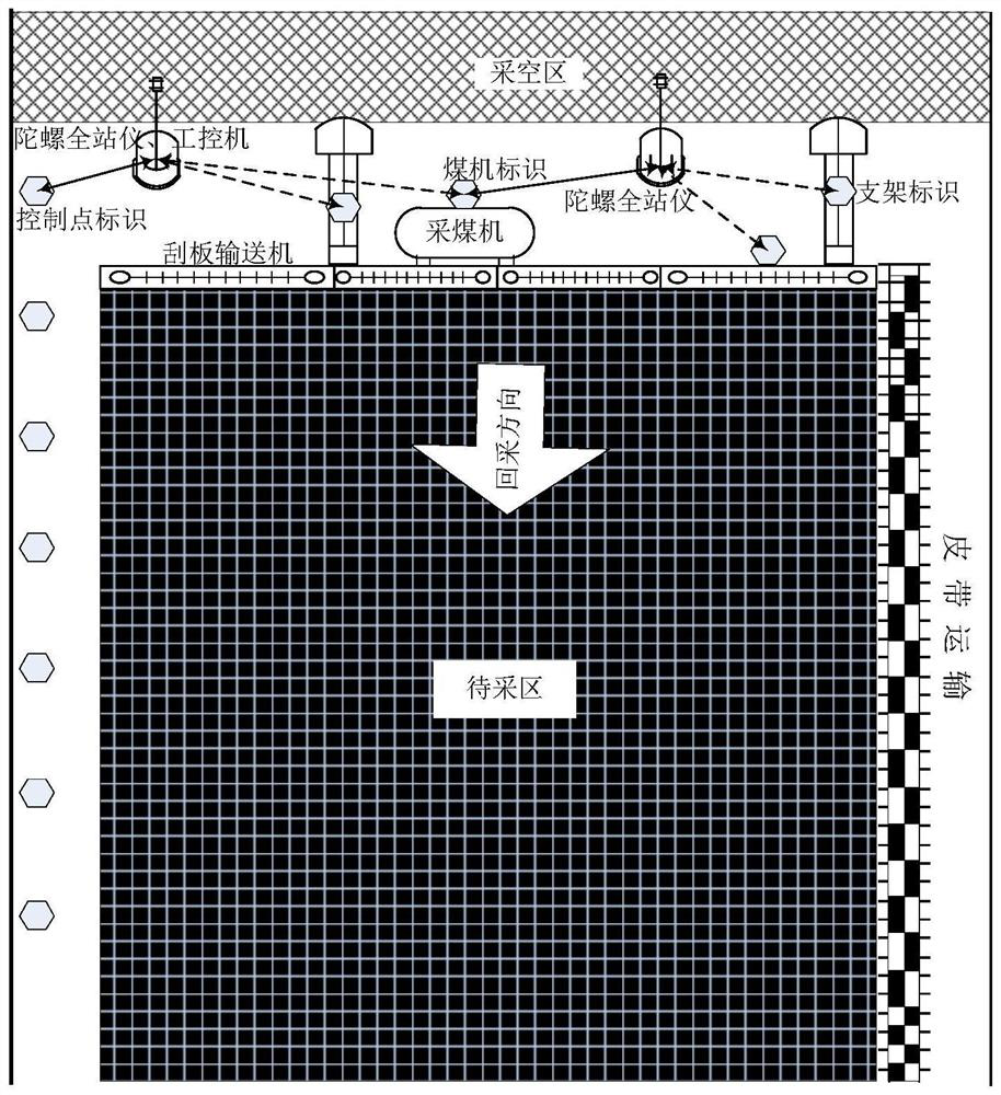
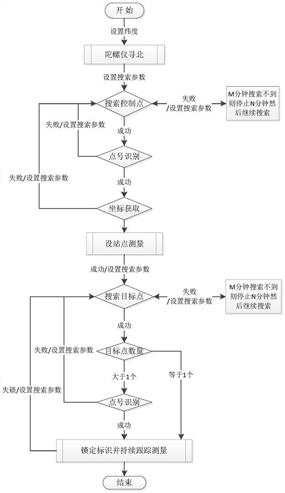
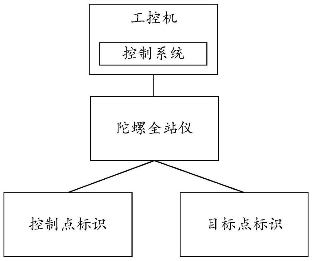
[0043] The concept of the present invention is to arrange a plurality of control point identifiers in advance in the mine, and measure the geodetic coordinates of the locations where these control point identifiers are located in advance. Use the geodetic coordinates to determine the geodetic coordinates of the gyro total station. Use the gyro total station to search for at least one target point, measure the relative position relationship between the gyro total station and each corresponding target point, and use the relative position relationship and the geodetic coordinates of the gyro total station to calculate the geodetic coordinates of the corresponding target point. To achieve the purpose of controlling the...


PUM


Abstract

The invention relates to a method for automatically measuring coordinates of a target point of a fully mechanized coal mining face and a measuring robot system. According to the embodiment of the invention, a gyro total station searches a known control point identifier and identifies a point number of the known control point identifier, and queries the point number and a corresponding geodetic coordinate in a control point data file or a database; the geodetic coordinates of the gyroscopic total station are determined according to the geodetic coordinates of the control points, the true northorientation angles of the coordinates from the control points to the gyroscopic total station and the angle distance measurement values of the gyroscopic total station; and according to the searchingazimuth angle and the angle range parameter, a fixed or moving target point identifier is searched in the fully mechanized coal mining face, the point number is identified, the geodetic coordinate ismeasured and calculated, and thus, geodetic coordinate-based relay conduction and positioning of the target point in the fully mechanized coal mining face of the mine are realized. A plurality of gyroscopic total stations can also be installed on the fully mechanized coal mining face to form a geodetic coordinate control network, and full coverage of the geodetic coordinate measurement area of thefixed or moving target point of the fully mechanized coal mining face is achieved.

Description

Technical field [0001] The invention relates to the field of computer technology, in particular to a method for automatically measuring the coordinates of a target point in a fully mechanized mining face and a measuring robot system. Background technique [0002] In March 2020, the National Development and Reform Commission, the National Energy Administration, the Ministry of Emergency Management, the National Coal Mine Safety Supervision Bureau, the Ministry of Industry and Information Technology, the Ministry of Finance, the Ministry of Science and Technology, and the Ministry of Education jointly issued the "Guiding Opinions on Accelerating the Development of Intelligent Coal Mines" "To comprehensively promote the transformation of coal mine intelligent technology from the national strategic level at an unprecedented height, and propose to promote the research and development and industrial application of coal mine robots. The purpose of intelligent mine construction is to hav...

Claims


Application Information

Patent Timeline
Patent Type & Authority Applications(China)
IPC IPC(8): G01C15/00G06F16/242
CPCG01C15/00G06F16/242
Inventor 毛善君李鑫超陈华州张鹏鹏
Owner BEIZHING LONGRUAN TEKNOLODZHIS INK
Learn More