Drilling data model construction method based on BIM

A technology of drilling data and construction methods, applied in the field of geotechnical engineering, can solve the problems of complex geological bodies that cannot establish relatively accurate geological body models, lack of calculation and model output interfaces, and error-prone and other problems

Active Publication Date: 2020-11-17
CHENGDU UNIVERSITY OF TECHNOLOGY
View PDF10 Cites 9 Cited by
  • Summary
  • Abstract
  • Description
  • Claims
  • Application Information

AI Technical Summary

Problems solved by technology

[0004] (1) Manual input of drilling data and manual modeling of rock and soil layers, the modeling workload is heavy and cumbersome, error-prone, modeling efficiency is extremely low and implementation is too difficult;
[0005] (2) When building a 3D geological model, it can only deal with conventional rock and soil strata, and it is difficult to deal with common phenomena such as lens and pinch-out rock and soil strata, and only rough modeling of rock and soil strata can be performed;
[0006] (3) Using Revit software to simulate foundation pit excavation can only be done manually for one rock and soil layer at the same time;
[0007] (4) Lack of calculation and model output interfaces related to geotechnical engineering investigation;
[0008] (5) The application of BIM to 3D geological models is not clear enough;
[0009] (6) It is impossible to establish a more accurate geological body model for complex geological bodies
[0010] To sum up, there are still many deficiencies and defects in the BIM of the 3D geological model at this stage, and it needs to be improved in the direction of increasing the degree of automation, efficient and accurate modeling, and in the application of the model.

Method used


Image

  • Drilling data model construction method based on BIM
  • Drilling data model construction method based on BIM
  • Drilling data model construction method based on BIM

Examples


Embodiment

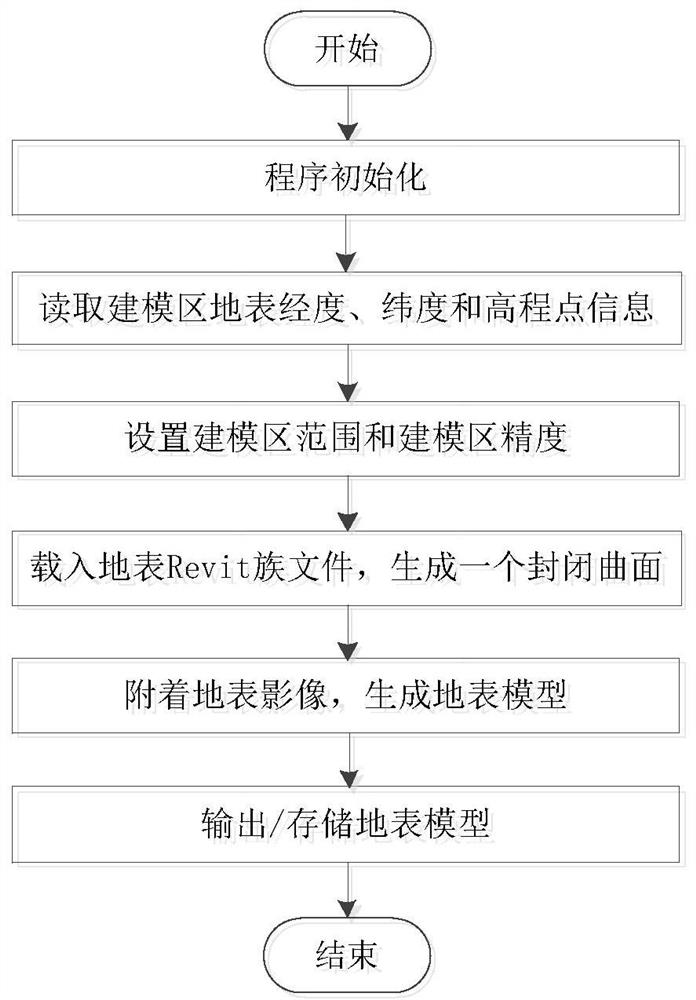
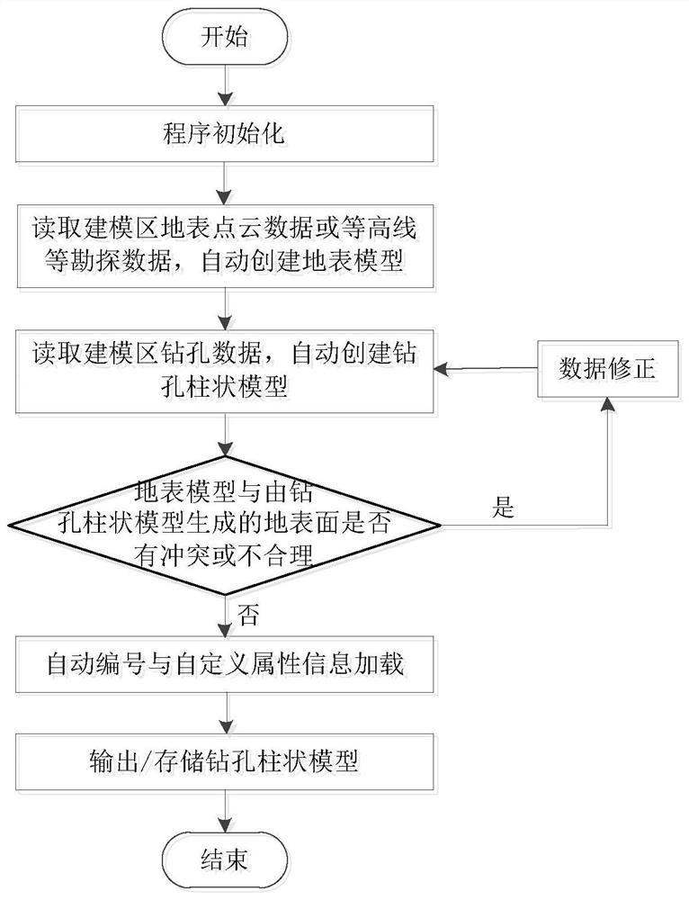
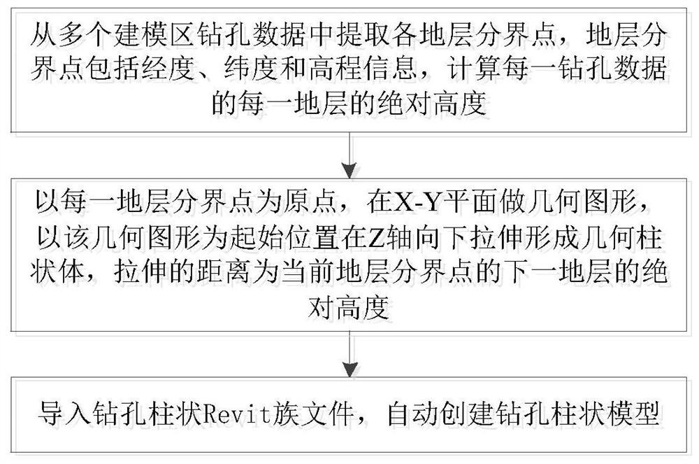
[0045] Such as Figure 1-3 As shown, a method for constructing a BIM-based borehole data model in this embodiment includes establishing a spatial information database according to various types of exploration data, and then performing the steps of creating a borehole data model. The steps for creating a borehole data model include:

[0046] Read the borehole data in the modeling area from the spatial information database, and automatically create the borehole data model;

[0047] Read the surface point cloud data or contour line and other exploration data of the modeling area from the spatial information database, and automatically create the surface model;

[0048] Determine whether the ground surface model and the ground surface generated by the borehole data model are in conflict or unreasonable, and if so, correct the borehole data in the modeling area; otherwise, automatically number and load custom attribute information, and output / store the borehole data model.

[0049...


PUM


Abstract

The invention discloses a drilling data model construction method based on BIM, and the method comprises the steps: building a spatial information database according to various types of exploration data, and then carrying out the building of a drilling data model: reading the exploration data of modeling region surface point cloud data or contour lines from the spatial information database, and automatically building a surface model; reading the drilling data of the modeling area from the spatial information database, and automatically creating a drilling data model; judging whether the groundsurface model conflicts with or is unreasonable with the ground surface generated by the drilling data model or not, and if so, correcting the drilling data of the modeling area; and if not, automatically numbering and loading user-defined attribute information, and outputting/storing the drilling data model. According to the method, automatic modeling is achieved, seamless butt joint of the building BIM model can be achieved, the simulation performance of traditional BIM application such as early-stage planning design, earthwork calculation and site construction simulation can be greatly improved, and the accuracy of geologic body numerical analysis in the engineering geology field is greatly improved.

Description

technical field [0001] The invention belongs to the technical field of geotechnical engineering based on BIM, and in particular relates to a method for constructing a drilling data model based on BIM. Background technique [0002] Geological information usually obtains basic data through drilling and other means, and uses drilling histograms, profiles and survey reports as the main forms of information. This method has long-term engineering experience, and the model and form are more standardized and professional, but it also has certain shortcomings, including inconvenient information access, strong specialization, stacked by a large amount of statistical data, and no effective three-dimensional display effects etc. However, with its powerful 3D rendering capabilities and information integration capabilities, BIM can also interact with a large amount of information with many softwares, and combine with GIS systems to improve efficiency, providing a new idea for the develop...

Claims


Application Information

Patent Timeline
Patent Type & Authority Applications(China)
IPC IPC(8): G06F30/12G06F30/20
CPCG06F30/12G06F30/20
Inventor 曾鹏陈洪秦扬张天龙
Owner CHENGDU UNIVERSITY OF TECHNOLOGY
Why Eureka
Try Eureka