A fixed-wing unmanned aerial vehicle, single-lens oblique photography system and method

A UAV and fixed-wing technology, applied in the field of UAV surveying and mapping, can solve the problems of uneven distribution of photo data resolution, difficulty in stably aligning the image sensor with the hovering center, and modeling failure, etc., to improve 3D modeling Efficiency, shortened total mission voyage, and reduced platform cost

Active Publication Date: 2022-06-17
广州飞图信息科技有限公司
View PDF15 Cites 0 Cited by
  • Summary
  • Abstract
  • Description
  • Claims
  • Application Information

AI Technical Summary

Problems solved by technology

[0010] 2. The image sequence of the fixed-wing UAV flying in a straight line and parallel to the oblique photography route contains a large amount of photos, and the post-processing is difficult
Among them, the number of invalid photos facing the periphery of the corresponding effective shooting area needs to be deleted is about 5250, and the number of valid photos involved in the calculation in the later stage is about 16750, and the amount of post-processing data is huge
[0012] 3. For fixed-wing UAVs equipped with at least two image sensors, there are problems such as difficulty in unifying the shutters of multiple cameras, serious power consumption, high procurement costs and operating costs, etc.
However, it is difficult for fixed-wing unmanned aerial vehicles to adopt the above-mentioned surround shooting. This is because the fixed-wing unmanned aerial vehicle is controlled by continuously controlling the roll attitude of the flight platform to adjust the velocity vector during the navigation control process. When the trajectory is stable and hovers around a point, its body is not in a stable state at any time, which makes it difficult for the image sensor mounted on the fixed wing to be stably aligned with the center of the circle, and the acquired photo data will be difficult to splice in the later stage due to uneven resolution distribution. Direct modeling fails, so fixed-wing UAVs are not used in the prior art for the above-mentioned surround aerial survey

Method used


Image

  • A fixed-wing unmanned aerial vehicle, single-lens oblique photography system and method
  • A fixed-wing unmanned aerial vehicle, single-lens oblique photography system and method
  • A fixed-wing unmanned aerial vehicle, single-lens oblique photography system and method

Examples


Embodiment 1

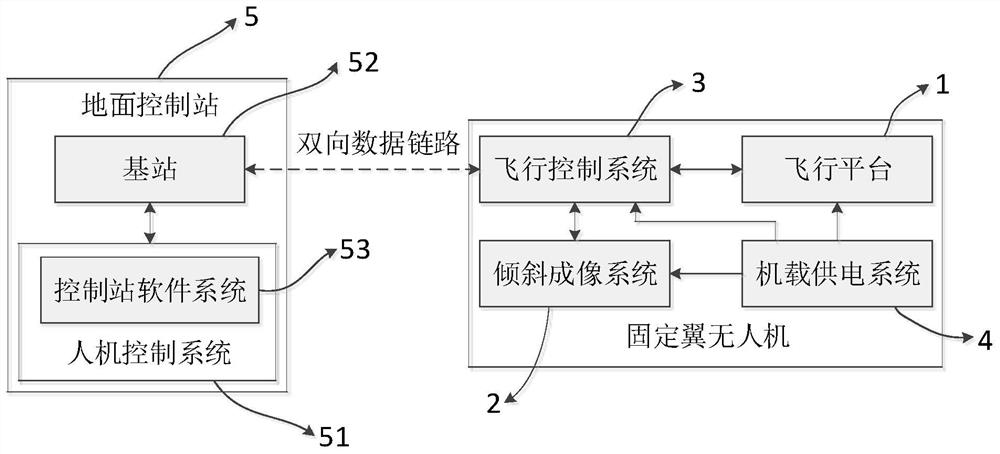
[0051] like figure 1 , figure 2 as well as Figure 5 As shown, the fixed-wing UAV provided in this embodiment includes a flight platform 1 , a tilt imaging system 2 , a flight control system 3 and an onboard power supply system 4 , and the flight platform 1 is used to execute the flight control instructions of the flight control system 3 , the tilt imaging system 2 is used to execute the stabilization control command and the shooting control command of the flight control system 3, and the flight control system 3 is used to communicate with the ground control station 5 and send control commands, which is the control center of the fixed-wing unmanned aerial vehicle, The onboard power supply system 4 is used to supply power to all electronic devices in the flight platform 1 , the tilt imaging system 2 , and the flight control system 3 .

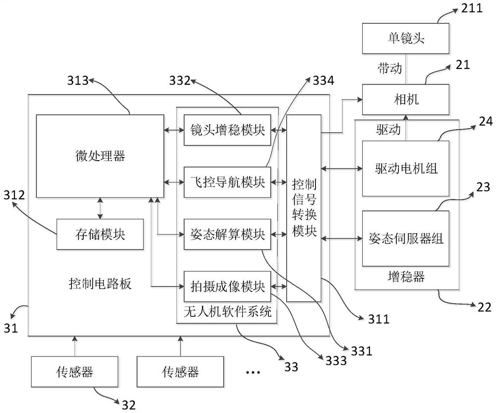
[0052] In order to perform the flight mission of the fixed-wing UAV, further, such as figure 2 , image 3 , Figure 4 and Figure 5 As...

Embodiment 2

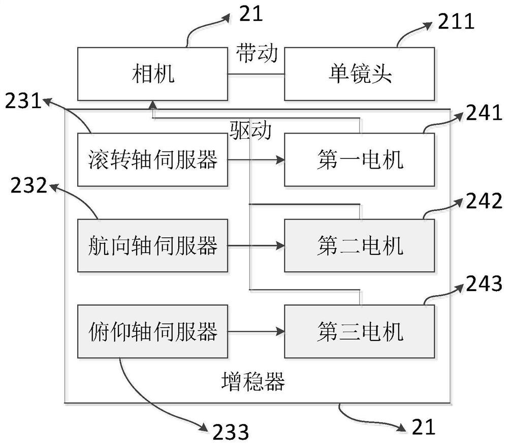
[0057] The present embodiment provides an oblique photographing method for the above-mentioned fixed-wing UAV, which is implemented according to the following steps: the stabilization control instruction includes an orbiting flight stabilization control instruction and a direct flight stabilization control instruction. When the fixed-wing UAV is When flying around according to the flying circle route, the lens stabilization module 332 sends a control command of the stabilization stabilization control to the attitude server group 23 of the stabilizer 22, and the attitude server group 23 drives the single lens 211 to adjust its attitude in real time for alignment. The circling center of the ring fly ring keeps the inclination angle of the single lens 211 constant. It should be noted that, since the single lens 211 is connected with the camera 21 as a whole, adjusting the tilt angle of the single lens 211 is also adjusting the tilt angle of the camera 21, and adjusting the posture...

Embodiment 3

[0065] This embodiment provides an oblique photography method for the above-mentioned fixed-wing UAV, which is implemented according to the following steps: when the fixed-wing UAV performs an orbiting flight according to the circumnavigation route, the lens stabilization module 332 sends out an orbiting increase The stability control command is sent to the attitude servo group 23 of the stabilizer 22, and the attitude servo group 23 drives the single lens 211 to adjust its attitude in real time to align with the circle center of the ring fly ring and keep the inclination angle of the single lens 211 constant. When the fixed-wing UAV flies horizontally according to the straight route, the lens stabilization module 332 sends a direct flight stabilization control command to the attitude server group 23, and the attitude server group 23 drives the single lens 211 to tilt the single lens 211. The angle is constant.

[0066] The difference between the third embodiment and the secon...


PUM


Abstract

The invention discloses a fixed-wing unmanned aerial vehicle, which belongs to the field of unmanned aerial vehicle surveying and mapping. The fixed-wing unmanned aerial vehicle includes a single lens, a flying platform, and a lens stabilization module for adjusting the attitude of the single lens. The flying platform There is a stabilizer on the top, and the single lens is fixed on the action end of the stabilizer. When the fixed-wing unmanned aerial vehicle is flying around according to the flying circle route, the attitude of the single lens is aligned with the flying circle. Hover the center and keep the tilt angle of the single lens constant. The present invention also discloses a single-lens oblique photography system and a corresponding single-lens oblique photography method for the fixed-wing unmanned aerial vehicle. The fixed-wing unmanned aerial vehicle disclosed in the present invention does not need to expand the route to adjust the attitude or obtain the image of the edge of the survey area through the expansion, and has the ability to surround the shooting. Its ability to cover the effective shooting area with a single lens is stronger than that of the prior art. The fixed-wing UAV equipped with multiple lenses has a shorter total route and fewer photos.

Description

technical field [0001] The invention relates to the field of unmanned aerial vehicle surveying and mapping, in particular to a fixed-wing unmanned aerial vehicle, a single-lens oblique photography system including the above-mentioned fixed-wing unmanned aerial vehicle, and a corresponding single-lens oblique photography method. Background technique [0002] Oblique photogrammetry technology is a new technology developed rapidly in the field of international surveying and mapping in recent years. It has changed the limitation that aerial survey remote sensing images can only be shot from the vertical direction. By carrying one or more image sensors, the image sequence of the effective shooting area is collected from multiple different angles, and the 3D modeling software uses the image sequence to generate an effective image sequence. The high-definition digital reality 3D model of the shooting area is widely used in navigation maps, land surveying and mapping, virtual realit...

Claims


Application Information

Patent Timeline
Patent Type & Authority Patents(China)
IPC IPC(8): G01C11/00B64D47/08
CPCB64D47/08
Inventor 谢增辉徐建文李国添黄盛杰
Owner 广州飞图信息科技有限公司
Why Eureka
Try Eureka