An intelligent geographic surveying and mapping device

A surveying and mapping device and geographic technology, applied in the field of surveying and mapping, can solve problems such as the loss of aerial survey data, the fall of drones, and the impact on the progress of geographic surveying and mapping, and achieve the effects of strong mobility, good control effect, and guaranteed surveying and mapping efficiency

Active Publication Date: 2022-04-15
临沂国控城市规划技术服务有限公司
View PDF5 Cites 0 Cited by
  • Summary
  • Abstract
  • Description
  • Claims
  • Application Information

AI Technical Summary

Problems solved by technology

[0005] During the aerial survey, in order to ensure the clarity and accuracy of the surveying and mapping, the UAV is often not too far from the aerial survey site, so that the UAV may hit foreign objects such as branches and birds. In severe cases, it is easy to cause the UAV to fall, resulting in The loss of aerial survey data affects the progress of geographic surveying and mapping

Method used


Image

  • An intelligent geographic surveying and mapping device
  • An intelligent geographic surveying and mapping device
  • An intelligent geographic surveying and mapping device

Examples


Embodiment 1

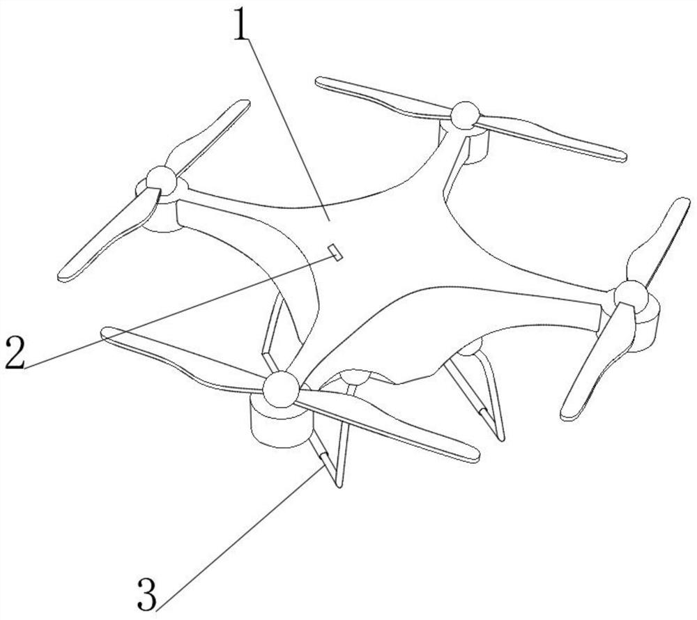
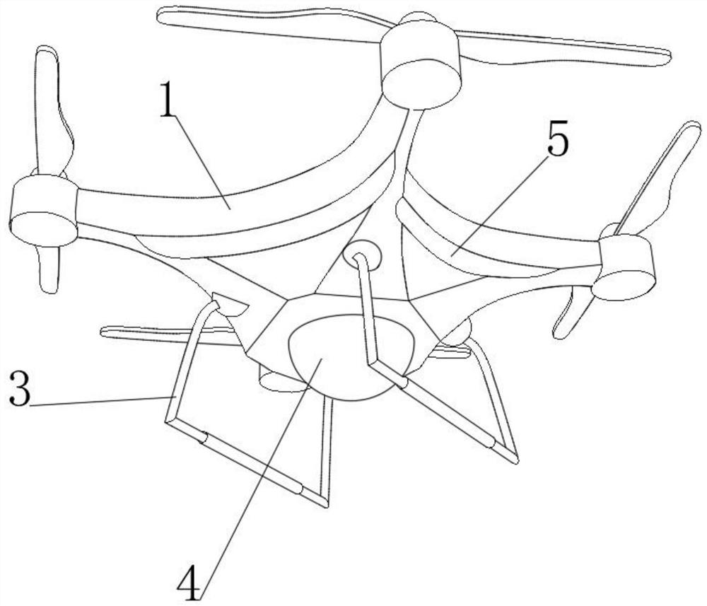
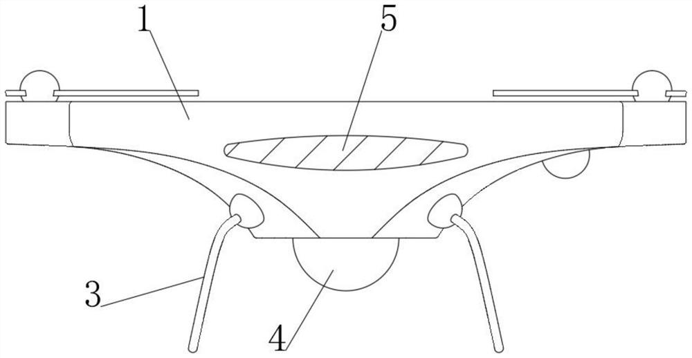
[0043] see Figure 1-3 , an intelligent geographic surveying and mapping device, comprising a surveying and mapping body 1, a GPS locator 2 is installed on the upper end of the surveying and mapping body 1, a high-definition camera 4 is installed on the lower end of the surveying and mapping body 1, and two mutually symmetrical brackets 3 are fixedly connected to the lower end of the surveying and mapping body 1 , the GPS locator 2 and the high-definition camera 4 are connected to the control chip signal in the surveying and mapping machine body 1, and the lower end of the surveying and mapping machine body 1 is fixedly connected with a stability control sheet 5 around the lower end. The stability control sheet 5 is located above the bracket 3. Made of high-quality materials, it has a certain bearing capacity. When the touch ball collides with the balance control bag, it is not easy to deform and unload the force, so that the stability control piece 5 is suitable for the survey...


PUM


Abstract

The invention discloses an intelligent geographic surveying and mapping device, which belongs to the field of surveying and mapping. An intelligent geographic surveying and mapping device, through the setting of the stability control sheet, when the surveying and mapping UAV loses balance due to an accidental impact, under the action of gravity , the touch tether ball quickly moves downward, so that it can squeeze the touch end on the balance control bag, so that the ends of the liquid storage ends on both sides of the touch end are arched, and the control liquid quickly enters the reverse control In the rod, the reverse control rod generates a thrust on the maintenance bead chain, so that the maintenance bead chain moves in the opposite direction of the loss of balance, thereby increasing the gravity of the tilting side of the surveying and mapping UAV, so as to achieve the stability of the surveying and mapping UAV. The effect of regulating the stability after an accidental impact can effectively ensure the normal progress of surveying and mapping, making the geographical surveying and mapping more efficient. At the same time, with the function of the position control rope, the center touch ball that can fall can move up quickly, thus assisting in maintaining stability. Regulation of stability by bead chains.

Description

technical field [0001] The invention relates to the field of surveying and mapping, more specifically, to an intelligent geographical surveying and mapping device. Background technique [0002] Geographical surveying and mapping is to measure the shape, size, spatial position and other attributes of natural geography, collect data and then draw it into a map. The research object is mainly the shape of the earth and its surface. Transportation construction and other fields. Simply put, surveying and mapping instruments are instruments and devices designed and manufactured for data acquisition, processing, and output for surveying and mapping operations. Various instruments for orientation, distance measurement, angle measurement, height measurement, mapping and photogrammetry required for surveying in the planning, design, construction and operation management stages of engineering construction. [0003] Modern surveying and mapping tools generally include the following: 3D...

Claims


Application Information

Patent Timeline
Patent Type & Authority Patents(China)
IPC IPC(8): B64C17/00B64C39/02B64D45/00
CPCB64C17/00B64C39/02B64D45/00B64U30/20B64U2101/30B64U10/10
Inventor 不公告发明人
Owner 临沂国控城市规划技术服务有限公司
Why Eureka
Try Eureka