Layered point cloud segmentation method based on DBSCAN

A technology of layered point and point cloud data, applied in the field of LiDAR point cloud data information extraction, can solve the problems of DBSCAN under-segmentation, over-segmentation, missing point cloud data, etc., and achieve the effect of improving computing efficiency

Active Publication Date: 2020-12-11
FUZHOU UNIV
View PDF7 Cites 17 Cited by
  • Summary
  • Abstract
  • Description
  • Claims
  • Application Information

AI Technical Summary

Problems solved by technology

[0015] 1) Two parameters, Eps (neighborhood radius) and MinPts (minimum number of points in the neighborhood), need to be selected in advance. However, during segmentation, since the density of different regions may be different, fixed Eps and MinPts will lead to both over-segmentation and under-segmentation ;
[0016] 2) Due to the lack of data in the point cloud data itself, the same object may be clustered into multiple objects;
[0017] 3) DBSCAN is prone to under-segmentation in intersecting scenes

Method used


Image

  • Layered point cloud segmentation method based on DBSCAN
  • Layered point cloud segmentation method based on DBSCAN
  • Layered point cloud segmentation method based on DBSCAN

Examples


Embodiment Construction

[0056] The technical solution of the present invention will be specifically described below in conjunction with the accompanying drawings.

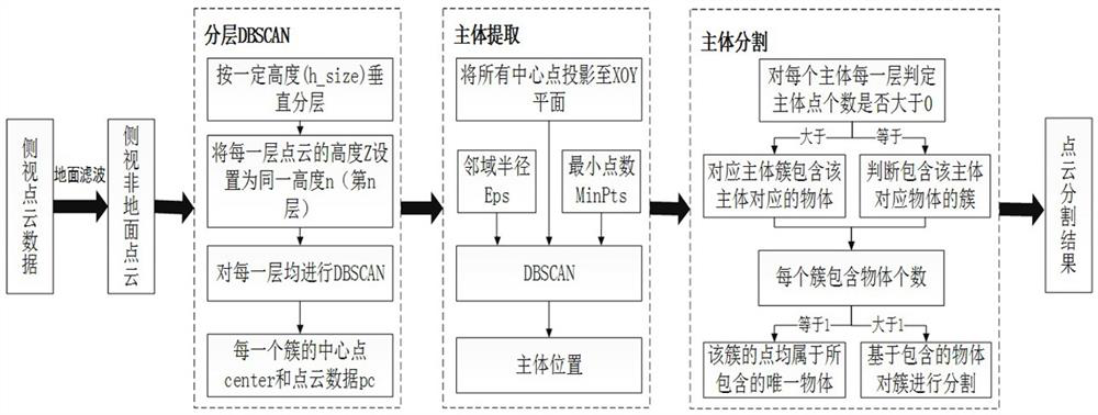
[0057] The invention provides a layered point cloud segmentation method based on DBSCAN, comprising the following steps:

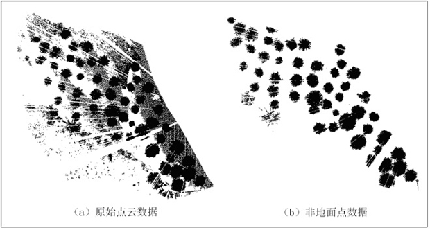
[0058] Step S0: Obtain the side-view laser point cloud data through the ground-based laser scanner or the mobile laser scanner, and use the cloth simulation filter algorithm CSF in the CloudCompare software to perform ground filtering on the point cloud data to segment ground points and non-ground points;

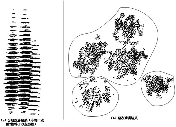
[0059] Step S1: Vertically stratify the point cloud data based on the layer height H of the non-ground point cloud, project each layer of point cloud data to the XOY plane and perform a DBSCAN clustering, and obtain the center point of each cluster ;

[0060] Step S2: According to the consistency of the position distribution of most objects at different heights, perform a DBSCAN clustering on the projection of all...


PUM


Abstract

The invention relates to a layered point cloud segmentation method based on DBSCAN. Firstly, a CSF is adopted to separate a ground point from a non-ground point; In a non-ground point segmentation process, point clouds in the vertical direction are layered according to a certain height, DBSCAN clustering is carried out on projection points of each layer on an XOY plane to obtain a central point ofeach cluster, all the clustered central points are projected to the XOY plane, and each object main body is clustered by utilizing DBSCAN to obtain a plurality of object main bodies; a judgment is made whether each main body point exists in each layer of each main body or not, judging the number of objects contained in each cluster, and finally, a cluster of multiple objects is segmented. For segmentation of side viewpoint cloud data, extraction of most of main bodies in a scene can be guaranteed, certain robustness is achieved, particularly, the invention has good performance in the scene with trees as the main component, and the result obtained through the method has certain significance in point cloud classification and point cloud three-dimensional reconstruction after point cloud segmentation.

Description

technical field [0001] The invention relates to the technical field of LiDAR point cloud data information extraction, in particular to a layered point cloud segmentation method based on DBSCAN. Background technique [0002] The traditional three-dimensional laser scanning technology is another new breakthrough in surveying and mapping technology after the GPS system. It uses the principle of laser ranging to quickly, accurately and continuously obtain information such as the three-dimensional coordinates and reflection intensity of a large number of dense points on the surface of the object. At present, it is widely used in the fields of forest ecology, urban change detection, urban road detection and planning, and robot environment perception. However, due to the uneven distribution of point cloud data, no semantic information, and even most point cloud data do not contain color information, it has caused great interference to the processing and application of point cloud d...

Claims


Application Information

Patent Timeline
Patent Type & Authority Applications(China)
IPC IPC(8): G06T7/10G06T7/30G06T7/62
CPCG06T7/10G06T7/30G06T7/62G06T2207/10032G06T2207/10012G06T2207/30181
Inventor 唐丽玉彭巍黄洪宇陈崇成
Owner FUZHOU UNIV
Why Eureka
Try Eureka