Airborne LIDAR three-dimensional plane detection method based on multi-valued voxel model

A detection method and voxel-valued technology, applied in the field of airborne LIDAR three-dimensional plane detection based on a multi-valued voxel model, can solve the problem of not clearly expressing laser point neighborhood and topology information, low efficiency, and difficulty in designing plane feature detection algorithms And other issues

Active Publication Date: 2020-12-18
LIAONING TECHNICAL UNIVERSITY
View PDF5 Cites 5 Cited by
  • Summary
  • Abstract
  • Description
  • Claims
  • Application Information

AI Technical Summary

Problems solved by technology

It can be seen that the above methods all use the data structure form of discrete point cloud, and although the discrete point cloud contains the 3D information of the original LiDAR data, it does not clearly express the neighborhood and topology information between laser points, which leads to a problem based on point cloud. The design of the plane feature detection algorithm is difficult and the efficiency is low

Method used


Image

  • Airborne LIDAR three-dimensional plane detection method based on multi-valued voxel model
  • Airborne LIDAR three-dimensional plane detection method based on multi-valued voxel model
  • Airborne LIDAR three-dimensional plane detection method based on multi-valued voxel model

Examples


Embodiment Construction

[0057] The specific embodiments of the present invention will be described in detail below in conjunction with the accompanying drawings.

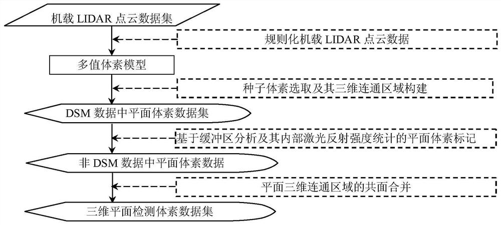
[0058] An airborne LIDAR 3D plane detection method based on a multi-valued voxel model, such as figure 1 shown, including the following steps:

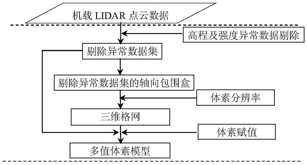
[0059] Step 1: Read the original airborne LIDAR point cloud data to form the original airborne LIDAR point cloud dataset.

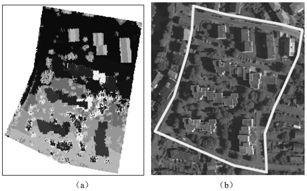
[0060] In this embodiment, the urban sample data provided by the International Society for Photogrammetry and Remote Sensing (International Society for Photogrammetry and Remote Sensing, ISPRS) third working group III / 4, which is specially used for the test of the target classification algorithm, is used as the experimental data (Area2, such as figure 2 (a) and figure 2 as shown in (b), figure 2 (a) is the airborne LiDAR point cloud in the data set, and is displayed according to the elevation; figure 2 (b) shows the digital aerial image of the corresponding area) to t...


PUM


Abstract

The invention discloses an airborne LIDAR three-dimensional plane detection method based on a multi-valued voxel model. The method comprises the following steps: regularizing airborne LIDAR point cloud data into the multi-valued voxel model; then searching for a small-curvature voxel from multi-value voxel model DSM data as a seed by utilizing the smoothness characteristic of a plane, and markinga communication area which is in three-dimensional communication with the seed and is consistent with the normal vector direction as the plane; marking voxels, of which reflection intensity values meet statistical characteristics, in the non-DSM data of the multi-valued voxel model as planes, wherein the voxels are located in the buffer area range of the connected region; and finally, merging theplane communication regions, so that the possibility that a real plane is segmented into a plurality of plane communication regions due to non-uniform point cloud density and the like is avoided. According to the method, a multi-valued voxel model construction scheme of airborne LIDAR point cloud data and a plane detection scheme based on the multi-value voxel model construction scheme are provided, and development of airborne LIDAR point cloud data processing and application based on the multi-value voxel model theory is facilitated.

Description

technical field [0001] The invention belongs to the technical field of remote sensing data processing, and in particular relates to an airborne LIDAR three-dimensional plane detection method based on a multi-valued voxel model. Background technique [0002] Plane features contain rich structural and semantic information, and widely exist in actual scenes, such as building roofs, walls, asphalt pavements, and natural ground. Accurate detection of this feature is of great significance for practical applications such as scene recognition and 3D reconstruction. Airborne LiDAR (Light Detection And Ranging, LIDAR) can directly acquire high-density, high-precision 3D point cloud data of ground objects. This data can provide rich information for automatic detection of 3D planar structures. Classical 3D planar feature detection methods based on airborne LIDAR data can be divided into the following two categories: fitting-based methods and cluster growth-based methods. Among them, ...

Claims


Application Information

Patent Timeline
Patent Type & Authority Applications(China)
IPC IPC(8): G01S17/88G01S7/48G06T7/521G06T17/05G06T17/20
CPCG01S17/88G01S7/4802G06T7/521G06T17/05G06T17/20G06T2207/10028G06T2207/30181Y02A90/10
Inventor 王丽英巩德真王鑫宁
Owner LIAONING TECHNICAL UNIVERSITY
Why Eureka
Try Eureka