Method for solving high-precision modeling of industrial park by using fixed-wing and multi-rotor unmanned aerial vehicle

An industrial park, unmanned rotor technology, applied in 3D modeling, special data processing applications, image data processing, etc., can solve problems such as the inability to design, plan and transform the overall model of the industrial park, and achieve the effect of reducing manual intervention

Pending Publication Date: 2020-12-29
BEIJING SHOUGANG INT ENG TECH
View PDF0 Cites 1 Cited by
  • Summary
  • Abstract
  • Description
  • Claims
  • Application Information

AI Technical Summary

Problems solved by technology

[0006] The purpose of the present invention is to provide a high-precision modeling method for industrial parks using fixed-wing and multi-rotor UAVs, which solves the problem that the overall model of the industrial park cannot be effectively applied to design planning and transformation

Method used


Image

  • Method for solving high-precision modeling of industrial park by using fixed-wing and multi-rotor unmanned aerial vehicle

Examples


Embodiment 1

[0021] The present invention is described in detail in combination with the accuracy requirements of the overall modeling of a steel plant. Specific steps are as follows:

[0022] 1 Equipment preparation, mainly for the fixed-wing equipped with a five-lens tilting aerial camera, the specific parameters are as follows:

[0023] Tianxing 6 tilt photography version adopts ultra-light tilt five-lens camera, single camera 24.3 million pixels, APS-C format, tilt camera uses 35mm dedicated aviation mechanical lens, five cameras with a total weight of 935 grams, which is the lightest in the industry High-performance large-area CCD fixed-wing aerial camera.

[0024]

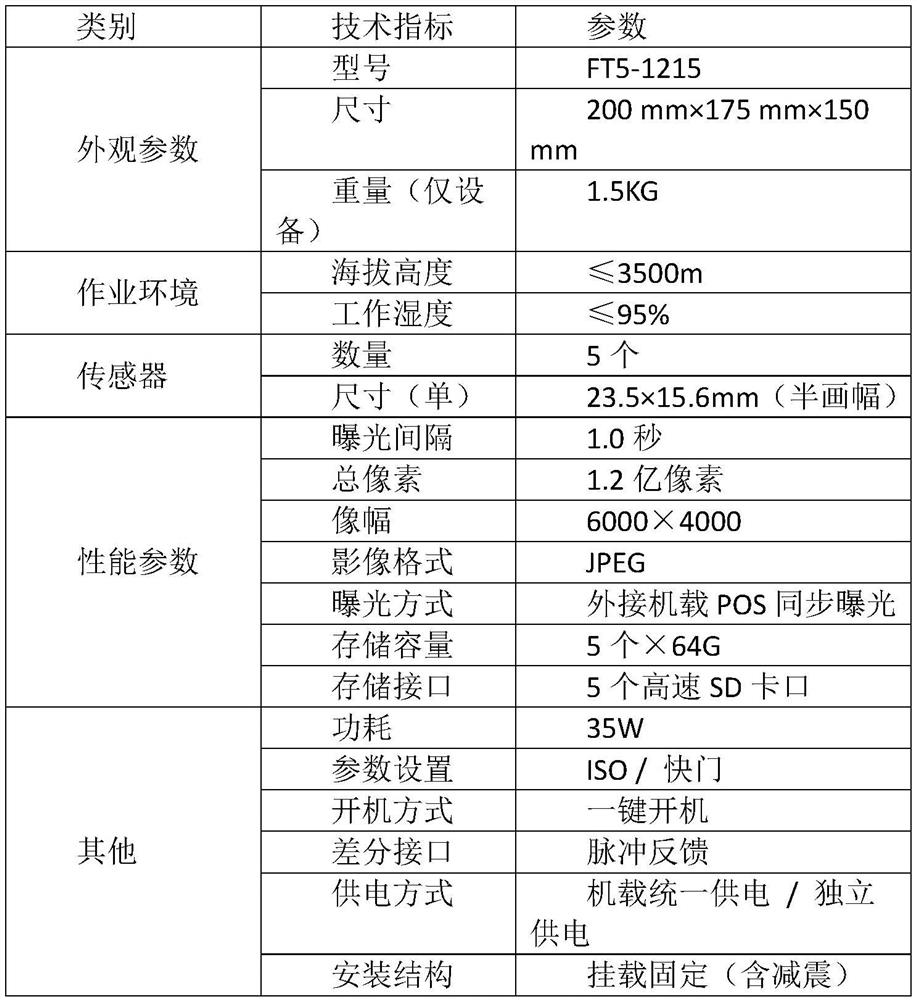
[0025] Parameters of multi-rotor five-lens aerial photography system

[0026] Through the above equipment, we obtain the original data of key areas in multiple dimensions and angles. Fully utilize the fixed-wing five-lens equipment with high operating efficiency, the multi-rotor five-lens equipment is simple and fle...


PUM


Abstract

The invention discloses a method for solving high-precision modeling of an industrial park by using a fixed-wing and multi-rotor unmanned aerial vehicle, and belongs to the technical field of industrial buildings. Image data are acquired by combining unmanned aerial vehicle aerial photogrammetry and ground photogrammetry, high-definition images of the whole survey area and main streets are fully acquired, and ground control points are acquired by matching with a classical ground control measurement method, so that the three-dimensional model precision of the survey area is improved, and the unification of a geographic coordinate system is improved. The method has the advantage that the problem that the whole industrial park model cannot be effectively applied to design planning transformation is solved; conditions for bearing basic information required by current situation statistics, planning analysis and demolition management are provided; and overall fine modeling of industrial building is realized.

Description

technical field [0001] The invention belongs to the technical field of industrial building modeling, and in particular relates to a method for solving high-precision modeling of industrial parks by using a fixed-wing and multi-rotor unmanned aerial vehicle, which realizes the overall fine modeling of industrial buildings. [0002] technical background [0003] Photogrammetry has gone through three stages in the history of surveying and mapping technology development, which are analog photogrammetry stage, analytical photogrammetry stage and digital photogrammetry stage, and now it has fully entered the era of full digital photogrammetry. It provides a fast, economical and high-precision high-tech production of 4D (DEM, DOM, DLG and DRG) products, and the general application area of ​​aerial photogrammetry is relatively large. It can be used in the civilian field more maturely, but it is less used in the industrial field, because the buildings in the industrial field are irreg...

Claims


Application Information

Patent Timeline
Patent Type & Authority Applications(China)
IPC IPC(8): G06T17/20G06F16/29G01C11/00G01C11/02
CPCG01C11/00G01C11/02G06T17/20G06F16/29
Inventor 张铁斌赵逸凡刘光
Owner BEIJING SHOUGANG INT ENG TECH
Why Eureka
Try Eureka