Remote sensing time sequence analysis-based abandoned land information extraction method and device

A technology of time series analysis and information extraction, applied in the field of abandoned land detection, it can solve the problems of discontinuous image time series and inability to obtain information on the distribution of abandoned abandoned land during the year, and achieve the effect of reducing spectral resolution requirements, high accuracy and high stability

Inactive Publication Date: 2021-01-01
HOHAI UNIV
View PDF0 Cites 12 Cited by
  • Summary
  • Abstract
  • Description
  • Claims
  • Application Information

AI Technical Summary

Problems solved by technology

[0005] The purpose of the present invention is to overcome the deficiencies in the prior art, to provide a remote sensing time-series abandoned land extraction method that can be applied on a larger spatial scale and meet the extraction accuracy of abandoned land, and solve the problem of extraction of abandoned land The image time series in the method is discontinuous, and there is a technical problem that it is impossible to obtain the distribution information of abandonment within the year

Method used


Image

  • Remote sensing time sequence analysis-based abandoned land information extraction method and device
  • Remote sensing time sequence analysis-based abandoned land information extraction method and device
  • Remote sensing time sequence analysis-based abandoned land information extraction method and device

Examples


Embodiment 1

[0035] This embodiment provides a method for extracting abandoned land information based on remote sensing time series analysis, which overcomes the discontinuous image time series existing in the existing abandoned land extraction method, the phenological characteristics of abandoned land cannot be completely obtained, and the distribution information of abandoned land within a year cannot be obtained. It is a problem that requires high spectral resolution of remote sensing images.

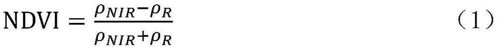
[0036] It includes the following steps: obtaining remote sensing image information; constructing NDVI (Normalized Difference Vegetation Index, normalized difference vegetation index) time series data set according to the obtained remote sensing image information, and constructing the NDVI continuous time series growth curve of vegetation within the range of cultivated land ; According to the NDVI continuous time-series growth change curve of the vegetation in the range of cultivated land, extract ...

Embodiment 2

[0058] This embodiment provides a method for extracting abandoned land information based on remote sensing time series analysis, which overcomes the discontinuous image time series existing in the existing abandoned land extraction method, the phenological characteristics of abandoned land cannot be completely obtained, and the distribution information of abandoned land within a year cannot be obtained. It is a problem that requires high spectral resolution of remote sensing images.

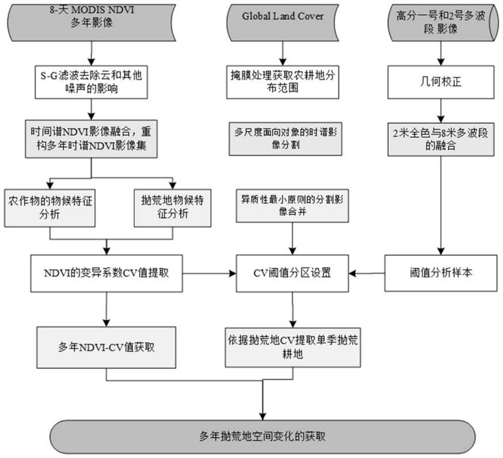
[0059] Firstly, remote sensing information must be obtained, which includes: 8-day MODIS NDVI multi-year images, GLC (GlobalLand Cover, global land cover product set) and Gaofen-1 and Gaofen-2 multi-band high-spatial resolution images; the Gaofen The No. 1 and No. 2 multi-band high-spatial-resolution images were used to extract the samples set by the threshold value of the model parameters in the abandoned land, as the basis for accurate coverage information of the abandoned land.

[0060] The re...

Embodiment 3

[0080] This embodiment provides a device for extracting wasteland information based on remote sensing time series analysis, which can implement the method for extracting wasteland information based on remote sensing time series analysis described in Embodiment 1. The device includes:

[0081] Remote sensing image acquisition module: used to acquire remote sensing image information;

[0082] NDVI construction processing module: used to construct NDVI time series data sets based on the acquired remote sensing image information, and construct NDVI continuous time series growth curves of vegetation within the range of cultivated land;

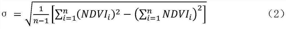
[0083] Coefficient of variation module: used to extract the parameter CV of the fluctuation intensity of the annual change curve of NDVI according to the NDVI continuous time-series growth change curve of vegetation within the range of cultivated land;

[0084] Distribution information module: used to extract the spatial distribution information of...


PUM


Abstract

The invention discloses a remote sensing time sequence analysis-based abandoned land information extraction method. The method comprises the following steps of obtaining remote sensing image information; constructing an NDVI time sequence data set according to the acquired remote sensing image information, and constructing an NDVI continuous time sequence growth change curve of vegetation in the cultivated land range; according to the NDVI continuous time sequence growth change curve of the vegetation in the cultivated land range, extracting the parameter CV of the fluctuation intensity of theintra-year change curve of the NDVI; and extracting spatial distribution information of the abandoned land from the cultivated land range according to the CV value. According to the method, the phenological characteristic difference analysis of the abandoned land and the cultivated land can be carried out by utilizing remote sensing intra-year and inter-year continuous time sequence images, and the growth characteristics of the abandoned land are represented by normalizing the CV of the intra-year change curve fluctuation intensity of the difference vegetation index NDVI, so that the distribution information of the abandoned land in the year is obtained; and aggregating the multi-year image time sequence set to extract multi-year abandoned land spatial distribution information, thereby obtaining multi-year abandoned land evolution information.

Description

technical field [0001] The invention relates to the field of wasteland detection, in particular to a method and device for extracting wasteland information based on remote sensing time series analysis. Background technique [0002] Cultivated land that is idle or underutilized for a certain period of time is called abandoned land or abandoned land, including fallow, multi-season planting changed to single-season, etc. Abandonment of cultivated land has become a common phenomenon in some areas of China, and seasonal abandonment of cultivated land has gradually evolved into perennial abandonment, which seriously threatens my country's food security. Land abandonment is also a growing global problem with strong ecological and socioeconomic effects. However, the monitoring of the spatial location and occurrence time of abandoned land is still a difficult point. In the context of growing demand for global agricultural products, accurate monitoring of the spatial and temporal di...

Claims


Application Information

Patent Timeline
Patent Type & Authority Applications(China)
IPC IPC(8): G06T7/00G06T7/136G06T5/00G06K9/46
CPCG06T7/0002G06T7/136G06T5/002G06T5/006G06T2207/10032G06T2207/30188G06V10/44
Inventor 吴太夏杨莹莹赵玉婷曾宇辉
Owner HOHAI UNIV
Why Eureka
Try Eureka