Method for establishing basic coordinate system of space positioning system

A space coordinate system and space positioning technology, applied in positioning, radio wave measurement system, complex mathematical operations, etc., can solve the problems of no substantive description, no flexibility, low precision of the reference coordinate system, etc., to improve installation and debugging efficiency, convenient control and measurement, and low algorithm complexity

Active Publication Date: 2021-01-05
天津市山石机器人有限责任公司
View PDF9 Cites 2 Cited by
  • Summary
  • Abstract
  • Description
  • Claims
  • Application Information

AI Technical Summary

Problems solved by technology

[0002]In 2016, Yu Kunlin et al. (Application Publication No.: CN 106211080A) applied for a patent "A Method for Self-Calibration of UWB Base Station Coordinates", which proposed using tags to calibrate the base station The changed position, but there is no substantive description in the patent on how to use tags to automatically calibrate the coordinates of the base station
[0003] In 2017, Zhu Xiaozhang et al. (Application Publication No.: CN 106990389A) applied for the "Method for Establishing a Coordinate System Between Base Stations in a Positioning System" and proposed that the use of The method of establishing the coordinate system by distance solves the problem of establishing the coordinate system by manual measurement with the help of measuring instruments such as total stations and laser rangefinders in the prior art. However, the existing problem is that when the positioning system establishes the coordinate system, first The approximate orientation of each base station needs to be clarified. In the case of non-line-of-sight or unclear orientation, positioning data cannot be obtained normally
[0004] In 2018, Tian Shiwei et al. (Application Publication No.: CN 109218967A) applied for the patent "UWB System Positioning Base Station Calibration Method and Its Equipment", which proposed that the manual measurement Measure the real coordinate value of the base station to be calibrated in the current positioning environment, and then establish a reference coordinate system. The reference coordinate system established in this way is not accurate and has the influence of human error.
[0005] In 2019, Xu Sheng et al. (Application Publication No.: CN 110290463A) applied for the patent "UWB Base Station Coordinate Automatic Calibration Method and System Based on Optimization Theory". , first place the base station and the tag in the corresponding position, construct the minimum UWB system, and use the optimization theory to optimize the residual sum of all theoretical distances and actual measurement distances, and then calibrate the system, to a certain extent, realize automation Calibration process, but for the establishment of the minimum UWB system reference coordinate system, the method of artificially specifying the base station and tag placement is still used, and there are many human decisions and no flexibility

Method used


Image

  • Method for establishing basic coordinate system of space positioning system
  • Method for establishing basic coordinate system of space positioning system
  • Method for establishing basic coordinate system of space positioning system

Examples


Embodiment 1

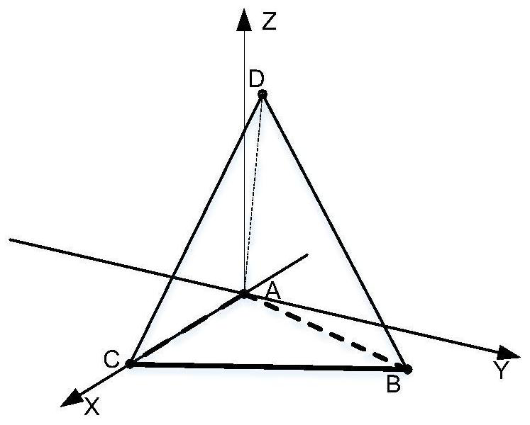
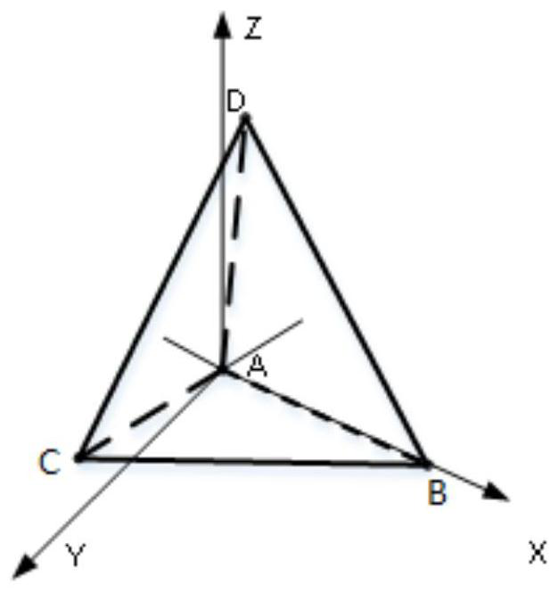
[0042] combined with Figure 1 to Figure 6 Description of this embodiment: a method for establishing a basic coordinate system for a space positioning system, the steps for establishing a basic coordinate system are:

[0043] In the case of satisfying the local area distribution density of distributed local positioning base stations, randomly install at least four non-coplanar base stations A, B, C, and D to form a basic positioning system, and the signal coverage of the four base stations has a common signal area;

[0044] The steps to establish a left-handed spatial positioning system are as follows: take the base station A as the coordinate origin, and the vector formed by the base stations A and B Is the X axis, with the X axis as a reference, establishes the Y axis in the plane ABC, and the Z axis points to the vertical direction where the base station D is located, and constructs a left-handed spatial coordinate system;

[0045] The steps to establish a right-handed s...

Embodiment 2

[0049]This embodiment is described in conjunction with Embodiment 1. The distance between two base stations is obtained by measuring each other between the base stations in the basic positioning system, which are expressed as

[0050]

[0051] By setting each orientation vector, it is convenient for subsequent calculations.

[0052] For further optimization, a virtual coordinate system is established based on the right-handed spatial positioning system, where

[0053] The coordinates of base stations A, B, C, and D are A(0,0,0), B(X B ,Y B ,0), C(b,0,0), D(X D , Y D ,Z D ),

[0054] in,

[0055] S represents the area of ​​△ABC,

[0056]

[0057] but

[0058] V represents the volume of the triangular pyramid D-ABC

[0059]

[0060] G=(c 2 +d 2 -e 2 ) 2

[0061] H=(b 2 +d 2 -f 2 ) 2

[0062] K=(b 2 +c 2 -a 2 ) 2

[0063] but:

[0064]

[0065] when d 2 -Z D 2 -X D 2 >0,

[0066]

[0067] d 2 -Z D 2 -X D 2 =0, Y D =0.

[...

Embodiment 3

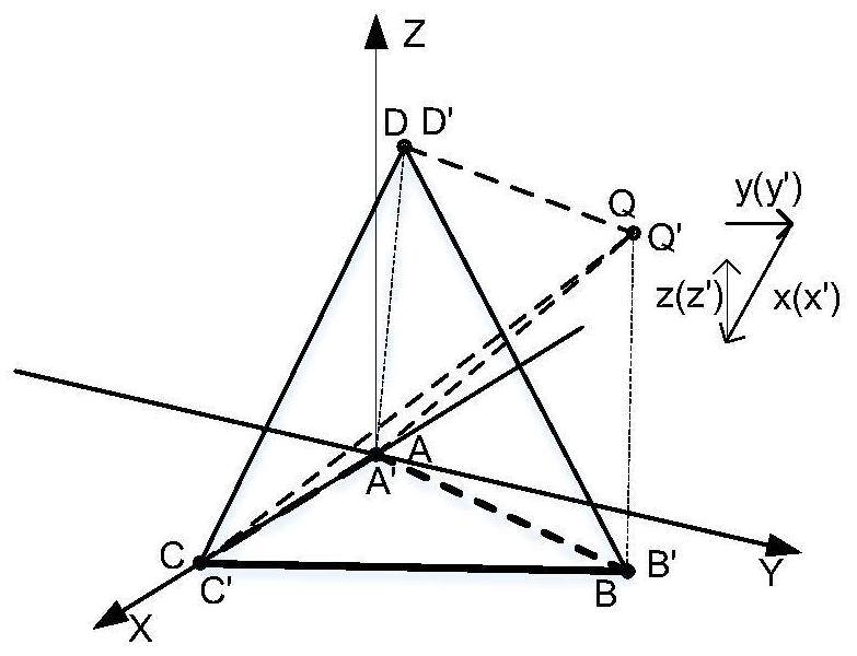
[0070] This embodiment is described in conjunction with Embodiments 1 and 2. The positions of the actual base stations A', B', C', and D' in the virtual coordinate system are the mapping of the lengths between any two base stations, namely Among them, A', B', C', D' and A, B, C, D are respectively mapped to each other. According to such a mapping relationship, the virtual coordinate system and the coordinate system corresponding to the actual base station are mirrored or consistent.

[0071] As a preference, when the points in the right-handed coordinate system correspond one-to-one with the virtual mapping points and the positions are consistent, move the beacon Q in space and move along the y→x→z trajectory, and in the virtual coordinate system, a Point Q' moves along y'→x'→z', and the vector coordinate system formed by this moving track is the right-handed spatial coordinate system track;

[0072] Furthermore, when the point in the left-handed coordinate system mirrors t...


PUM


Abstract

A method for establishing a basic coordinate system of a space positioning system belongs to the technical field of wireless positioning, and comprises the following steps: randomly installing at least four non-coplanar base stations A, B, C and D to form a basic positioning system; establishing a left-handed spatial positioning system or a right-handed spatial positioning system; calculating thedistance between every two base stations; calculating coordinates of base stations A, B, C and D in the virtual coordinate system; verifying the relationship among the left-handed coordinate system, the right-handed coordinate system and the virtual coordinate system; determining the value of the vertical coordinate ZD of the D point base station; fitting the alpha plane under the virtual coordinate system; rotating a beta plane of the virtual coordinate system; conducting translation of the virtual coordinate system. A gesture recognition algorithm is adopted to realize three-dimensional space positioning, a beacon space moving method is adopted to determine the position of a base station in a reference coordinate system, and the method has the advantages that the efficiency is high, andthe installation and deployment of the positioning base station are random and easy to realize.

Description

technical field [0001] The invention relates to the technical field of wireless positioning, in particular to a method for establishing a basic coordinate system in a space positioning system. Background technique [0002] In 2016, Yu Kunlin et al. (Application Publication No.: CN 106211080A) proposed in the patent "A UWB Base Station Coordinate Self-Calibration Method" that tags are used to calibrate the changed position of the base station, but there is no substantive explanation in the patent. Use labels to automatically calibrate the coordinates of the base station. [0003] In 2017, Zhu Xiaozhang et al. (Application Publication No.: CN 106990389A) proposed in the patent "Method for Establishing a Coordinate System Between Base Stations in a Positioning System" that the method of establishing a coordinate system by using the distance between base stations solves the problem of using the full range of coordinate systems in the prior art. Station instrument, laser range f...

Claims


Application Information

Patent Timeline
Patent Type & Authority Applications(China)
IPC IPC(8): G01S5/02G06F16/29G06F17/16G06F17/18
CPCG01S5/02G06F16/29G06F17/16G06F17/18
Inventor 雷帅锋戴宇辉郭立强
Owner 天津市山石机器人有限责任公司
Why Eureka
Try Eureka