
Geographic position-based point cloud information extraction system

A point cloud information and extraction system technology, applied in image data processing, instruments, calculations, etc., can solve problems such as inaccurate detection results, out-of-sync detection data time, etc., to achieve the effect of ensuring time synchronization

Pending Publication Date: 2021-01-08
NORTH CHINA UNIV OF WATER RESOURCES & ELECTRIC POWER
View PDF0 Cites 0 Cited by
  • Summary
  • Abstract
  • Description
  • Claims
  • Application Information

AI Technical Summary

Problems solved by technology

[0005] The purpose of the present invention is to provide a point cloud information extraction system based on geographic location to solve the problem of inaccurate detection results in the prior art due to the time asynchronous detection data of each detection device

Method used


Image

  • Geographic position-based point cloud information extraction system
  • Geographic position-based point cloud information extraction system
  • Geographic position-based point cloud information extraction system

Examples


Embodiment Construction

[0027] The purpose of the present invention is to provide a point cloud information extraction system based on geographic location to solve the problem in the prior art that the detection results are inaccurate due to the time asynchronous detection data of each detection device.

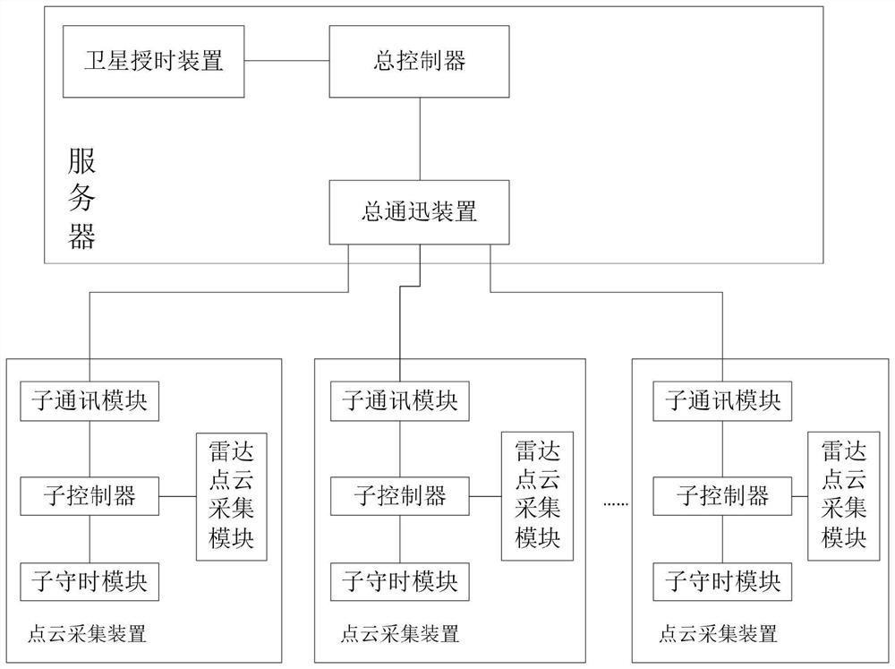
[0028] The location-based point cloud information extraction system provided in this embodiment has a structure such as figure 1 As shown, it includes a server and multiple point cloud acquisition devices. Server comprises general controller, and general controller is connected with total time service device and total communication device, and total time service device in the present embodiment is GPS satellite time service device; Point cloud acquisition device comprises sub-controller, and sub-controller is connected with sub-timekeeping module , a sub-communication module and a radar point cloud acquisition module, the sub-timing module includes a corresponding crystal oscillator, and the sub-con...


PUM


Abstract

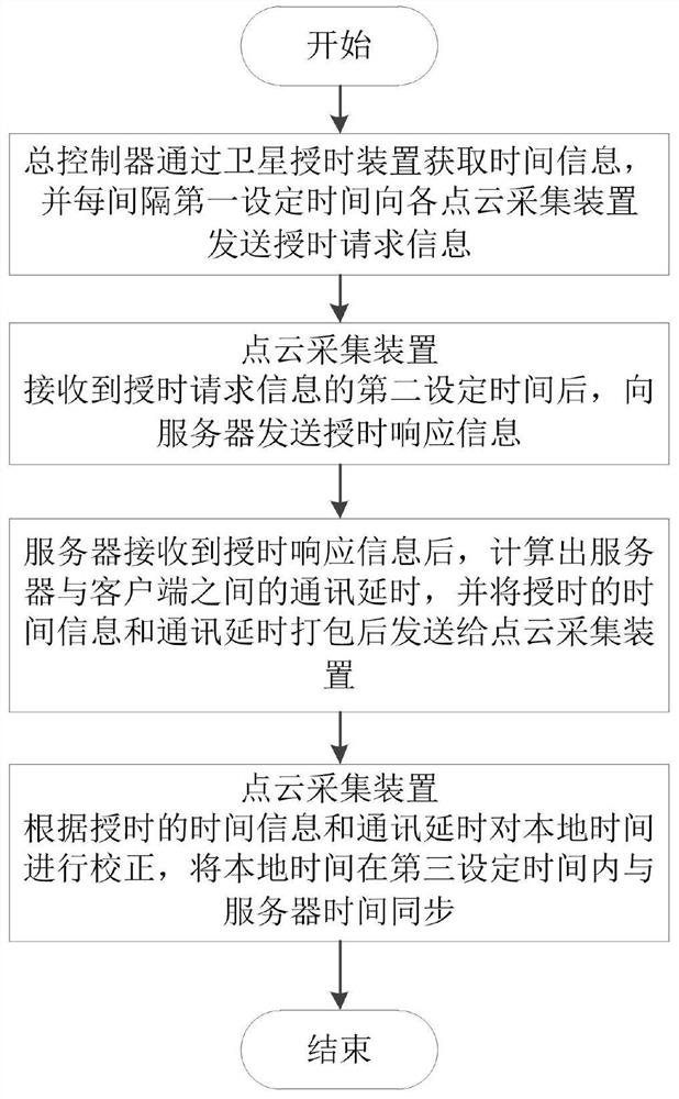
The invention provides a geographic position-based point cloud information extraction system. The geographic position-based point cloud information extraction system comprises a server and a point cloud acquisition device, a master controller of the server is connected with a satellite time service device; the server sends time service request information to each point cloud acquisition device atintervals of first set time; after receiving the second set time of the time service request information, the point cloud acquisition device sends time service response information to the server; after receiving the time service response information, the server calculates the communication delay between the server and the point cloud acquisition device, packages the time information and the communication delay acquired from the satellite time service device and sends the packaged time information and the packaged communication delay to the point cloud acquisition device; and the point cloud acquisition device corrects the local time according to the received time information and the communication delay, synchronizes the local time with the server time within a third set time, and monotonically increases the local time within the third set time. According to the technical scheme provided by the invention, the problem of inaccurate detection result caused by asynchronous time can be solved.

Description

technical field [0001] The invention belongs to the technical field of point cloud information extraction, and in particular relates to a geographical location-based point cloud information extraction system. Background technique [0002] Lidar technology can quickly acquire high-density and high-precision laser point cloud data, and through post-processing point cloud data, it can establish a three-dimensional model with centimeter-level accuracy. This refined technology has been applied to various levels of military and civilian use, such as unmanned driving, virtual reality, construction engineering, etc. However, due to the huge amount of data collected by this technology (usually terabytes), how to effectively store and manage these massive data, fast processing based on massive data, modeling of 3D stereo models, and real-time retrieval based on massive spatial data still exist. The technical bottleneck has become an obstacle to the widespread application of lidar tec...

Claims


Application Information

Patent Timeline
Patent Type & Authority Applications(China)
IPC IPC(8): G06T7/00G06T7/11G06T7/62
CPCG06T7/0002G06T7/11G06T7/62G06T2207/10028
Inventor 张俊峰沈燕田伟丽
Owner NORTH CHINA UNIV OF WATER RESOURCES & ELECTRIC POWER
Learn More