Disaster weather satellite cloud atlas classification method and device

A technology of satellite cloud image and classification method, which is applied in the field of disaster weather satellite cloud image classification, can solve problems such as satellite cloud image imbalance, achieve the effect of improving accuracy, reducing accuracy, and enhancing robustness

Inactive Publication Date: 2021-01-12
ZHEJIANG UNIV OF TECH
View PDF11 Cites 3 Cited by
  • Summary
  • Abstract
  • Description
  • Claims
  • Application Information

AI Technical Summary

Problems solved by technology

[0005] The purpose of this application is to provide a method and device for classifying disaster weather satellite cloud images, aiming at solving the problem of better classification of disaster weather satellite cloud images under the condition of unbalanced satellite cloud images

Method used


Image

  • Disaster weather satellite cloud atlas classification method and device
  • Disaster weather satellite cloud atlas classification method and device
  • Disaster weather satellite cloud atlas classification method and device

Examples


Embodiment 1

[0076] 1. Dataset

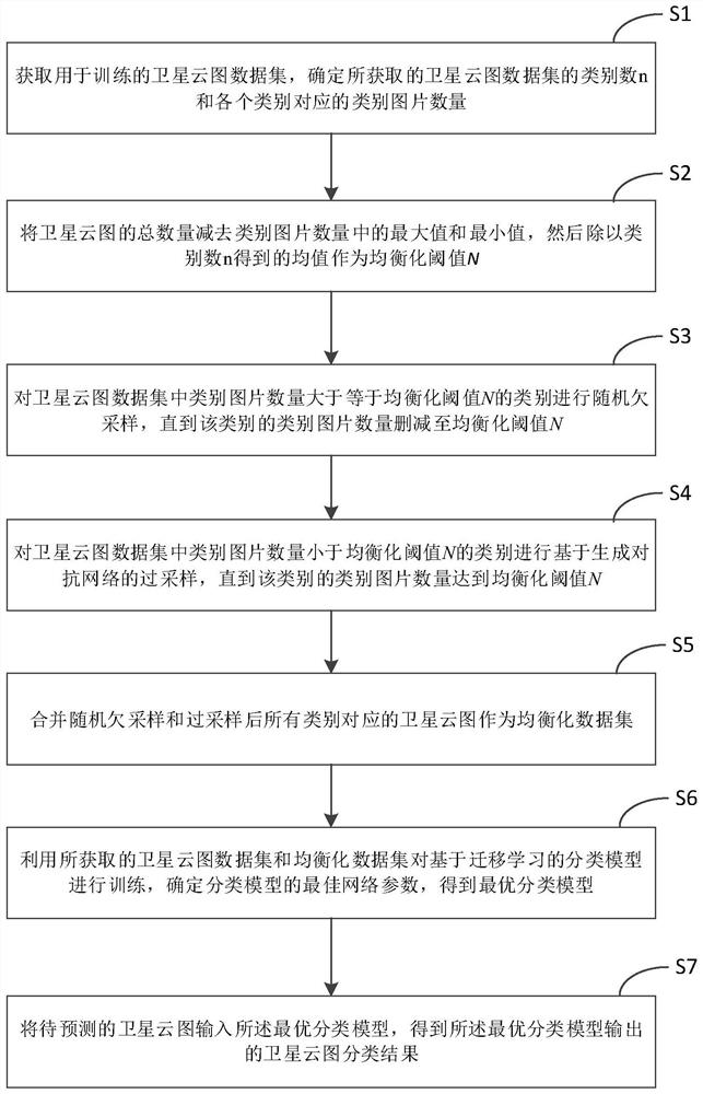
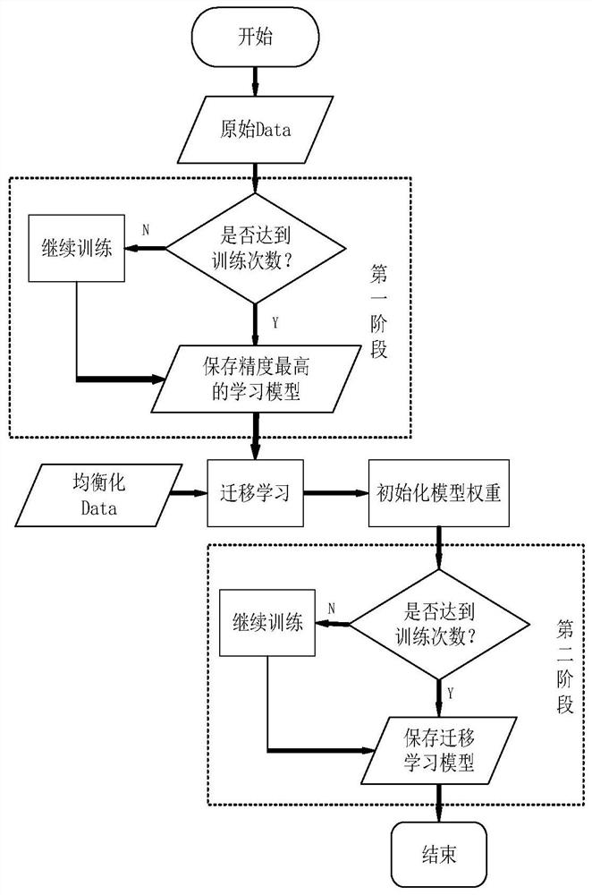
[0077] The experimental data set in this embodiment uses a self-built data set, which is called Large-scale Satellite Cloud Image Database for Weather System (LSCIDWS-S [17]). LSCIDW-S is a single-label dataset of large-scale static meteorological cloud images established by the Sunflower-8 meteorological satellite as the data source.

[0078] The data collection time span of this dataset is one year, including extratropical cyclones, tropical cyclones, fronts, westerly jet streams, snowfall, high ice clouds, low water clouds, oceans, deserts, vegetation and a total of 104,390 images in eleven categories. The original size of the picture is 1000*1000 pixels.

[0079] Since this application mainly focuses on the classification and identification of disastrous weather, high ice clouds, low water clouds, oceans, deserts, vegetation and others are combined into non-disaster weather categories. Table 1 shows the distribution of each category in the dataset.

...


PUM


Abstract

The invention discloses a disaster weather satellite cloud atlas classification method and device, and the method comprises the steps: undersampling and oversampling an unbalanced satellite cloud atlas, carrying out sample generation through a generative adversarial network, achieving the oversampling of samples, replacing the conventional simple copying, and generating data through the generativeadversarial network. Compared with data generated through simple copying, the data generated through simple copying can better fit the distribution probability, texture characteristics and other information of original data, and therefore the robustness in the model training process can be enhanced; meanwhile, training is carried out through transfer learning, feature information of samples withthe large original data size can be reserved to a large extent, and therefore when transfer training is carried out on a data set obtained after data equalization processing, the precision of large-class samples can be reduced as much as possible, and meanwhile the precision of each small number of samples is improved.

Description

technical field [0001] The invention belongs to the technical field of unbalanced satellite cloud image classification, in particular to a method and device for disastrous weather satellite cloud image classification. Background technique [0002] 75% of the world's economic losses are caused by severe weather, and more than 10,000 people die every year due to severe weather. Disaster weather, including typhoons, strong convection and sandstorms, seriously threatens the safety of people's lives and property. Monitoring the formation and development of disaster weather is the basis for meteorological disaster forecasting. Monitoring by observing satellite cloud images is one of the important means, because most of the earth is covered by clouds, and various weather phenomena are always inextricably linked with clouds. Satellite cloud images are top-down images of cloud coverage and the earth's surface observed by meteorological satellites. They can be used to identify differ...

Claims


Application Information

Patent Timeline
IPC IPC(8): G06K9/62G06K9/00
CPCG06V20/13G06F18/214G06F18/24
Inventor 白琮张敏靖郑建炜张敬林
Owner ZHEJIANG UNIV OF TECH
Why Eureka
Try Eureka