Storm surge simulation method based on WRF land cover data replacement

A technology of data replacement and simulation method, which is applied in the field of offshore engineering, can solve the problems that the built-in land cover data has a long time and does not conform to the actual situation of the research area, so as to achieve good simulation and prediction and improve the accuracy

Pending Publication Date: 2021-01-15
SOUTHEAST UNIV
View PDF0 Cites 1 Cited by
  • Summary
  • Abstract
  • Description
  • Claims
  • Application Information

AI Technical Summary

Problems solved by technology

[0004] Although WRF is widely used and reliable, its built-in land cover data is not in line with the actual situation of

Method used


Image

  • Storm surge simulation method based on WRF land cover data replacement
  • Storm surge simulation method based on WRF land cover data replacement
  • Storm surge simulation method based on WRF land cover data replacement

Examples


Embodiment 1

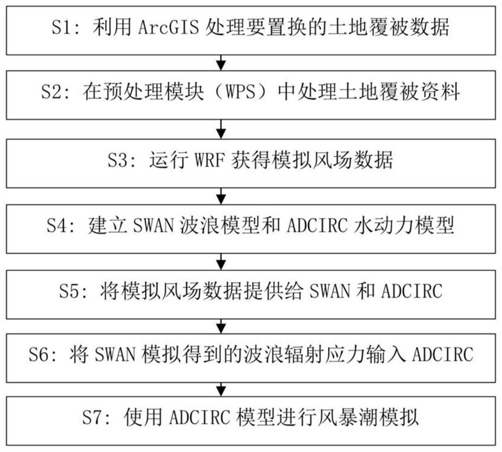
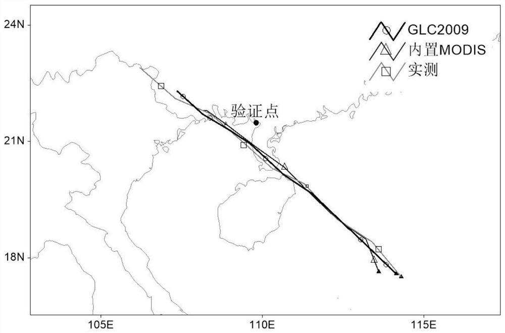
[0049] In this embodiment, Typhoon Rammasun is selected for research, and the best simulation parameters of Typhoon Rammasun are used, that is, the Lin scheme is used for the microphysical parameters, and the KF scheme is used for the cumulus parameters. A comparative study of wind field simulation before and after replacement of land cover data for typhoon Rammasun No. 1409.

[0050] see figure 2 , Use the ArcMap section in ArcGIS to process the downloaded GLC2009 global land cover data to replace the MODIS data built in WRF, including projection format conversion, cropping, resampling, reclassification, and conversion to ASCII. Because the GLC2009 data itself is a raster format, there is no need for vector-raster format conversion.

[0051] Then in the preprocessing module (WPS) in the WRF mode, format conversion, geographic coordinates and other parameter definitions are performed on the data processed by ArcGIS. Because in the WRF meteorological model, the static land c...


PUM


Abstract

The invention provides a storm surge simulation method based on WRF land cover data replacement. The storm surge simulation method comprises the following steps: S1, using ArcGIS for processing land cover data to be replaced; s2, processing land cover data in a preprocessing module in the WRF mode; s3, operating the WRF to obtain simulated wind field data; s4, establishing an SWAN wave model and an ADCIRC hydrodynamic model; s5, respectively providing the simulated wind field data after the replacement of the land cover data for the SWAN wave model and the ADCIRC hydrodynamic model; s6, inputting the wave radiation stress obtained by simulation of the SWAN model into an ADCIRC model; and S7, performing storm surge simulation by using the ADCIRC model. According to the invention, the WRF-SWAN-ADCIRC coupling model is comprehensively used, the method can be used for simulating the storm surge in the bay area of the sea mouth, outdated built-in land cover data in the WRF are replaced, andthe accuracy of storm surge simulation is improved.

Description

technical field [0001] The invention belongs to the technical field of offshore engineering, and mainly relates to a storm surge simulation method based on WRF land cover data replacement. Background technique [0002] my country is one of the countries most severely affected by typhoons in the world. On average, about 7 to 8 typhoons make landfall every year. The strong winds and waves brought by the typhoon process have brought huge disasters to the coastal areas. Accurate forecasting and simulation of typhoons and storm surges can help predict extreme high water levels and reduce losses caused by typhoon disasters, which is of great practical significance. The effect of storm surge simulation is greatly affected by the input wind field driving data, so how to obtain more accurate wind field simulation data is the key to storm surge simulation. [0003] Among the existing more advanced wind field simulation technologies, the WRF model (Weather Research and Forecasting Mod...

Claims


Application Information

Patent Timeline
IPC IPC(8): G06F30/23G06F30/28
CPCG06F30/23G06F30/28
Inventor 殷锴徐宿东周润朴冒刘燕唐爽张妮妮
Owner SOUTHEAST UNIV
Why Eureka
Try Eureka