Urban surface feature refined classification method combining airborne LiDAR point cloud data and aerial images

A technology of ground object classification and aerial imagery, which is applied in the field of refined extraction of urban ground objects, can solve problems such as difficult realization of three-dimensional hierarchical fusion classification, classification error, and difficult realization

Pending Publication Date: 2021-01-19
LINYI UNIVERSITY
View PDF0 Cites 5 Cited by
  • Summary
  • Abstract
  • Description
  • Claims
  • Application Information

AI Technical Summary

Problems solved by technology

Although this method can significantly improve the classification accuracy, the classification result is still two-dimensional, and there will inevitably be information loss in the process of interpolating the three-dimensional LiDAR point cloud to obtain a two-dimensional image, and the interpolation process may also bring problems to the classification. error
There are also studies that try to map the spectral and texture information of the image to the point cloud to support fusion classification, but this feature-level fusion requires precise registration of the two data, which is difficult to achieve, which makes it difficult to achieve three-dimensional fusion classification

Method used


Image

  • Urban surface feature refined classification method combining airborne LiDAR point cloud data and aerial images
  • Urban surface feature refined classification method combining airborne LiDAR point cloud data and aerial images
  • Urban surface feature refined classification method combining airborne LiDAR point cloud data and aerial images

Examples


Embodiment Construction

[0027] In order to make the object, technical solution and effect of the present invention more clear and definite, the technical solution will be described in detail below in conjunction with the embodiments of the present invention. It should be understood that the specific embodiments described here are only used to explain the present invention, not to limit the present invention. Based on the embodiments of the present invention, all other embodiments obtained by persons of ordinary skill in the art without making creative efforts belong to the protection scope of the present invention.

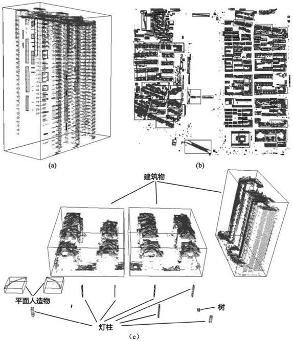
[0028] In the embodiment of the present invention, such as figure 1 As shown in the figure, a fine extraction method of urban features combined with airborne LiDAR and high-definition images is provided, and significant classification features are selected for different features, and the water body, ground, trees, shrubs, grasslands, and buildings are realized in a step-by-step manner. ...


PUM


Abstract

The invention discloses an urban surface feature refined classification method combining point cloud data of an airborne laser radar (LiDAR) and a high-definition aerial image, and aims to realize three-dimensional refined extraction of urban complex surface features in a stepped manner by adopting effective classification features for different surface features. The method comprises the followingsteps: firstly, point cloud hole tracking is carried out to realize extraction of a water body, and an improved point cloud filtering method of a progressive encryption triangulation network is adopted to realize extraction of ground points; then vegetation extraction is realized by utilizing a vegetation index image obtained by calculating a high-resolution aerial image, a vegetation point cloudcan be obtained by projecting an extraction result onto the point cloud, and on the basis, classification of tree, shrub and grassland point clouds is sequentially realized by adopting a top-down segmentation strategy. And finally, point cloud segmentation is performed on the remaining unclassified point clouds by adopting a clustering method of three-dimensional mark connectors, and identification rules for segmentation blocks are proposed, so that single extraction of buildings, bridges and lamp pole points is realized.

Description

technical field [0001] The invention relates to the combination of airborne LiDAR point cloud data and aerial images to realize the refined extraction of urban features, and in particular to a three-dimensional object-oriented classification method for ground features. Background technique [0002] Urban land use classification is the premise of many urban research work and urban management and planning. Using remote sensing data to realize the extraction of land use type information has always been one of the most important applications of remote sensing technology. In recent years, with the development of remote sensing technology, more and more data acquisition platforms (satellite, airborne, near-ground) and sensors (active, passive) provide people with multi-temporal and multi-resolution spatial data. Fine extraction and classification of urban features. Among them, high-resolution remote sensing images can provide sub-meter-level high-definition observation data, prov...

Claims


Application Information

Patent Timeline
Patent Type & Authority Applications(China)
IPC IPC(8): G06K9/00G06K9/34G06K9/62
CPCG06V20/176G06V20/182G06V20/188G06V10/267G06F18/24
Inventor 翟秋萍任仲亮史云飞孙华生宋福成
Owner LINYI UNIVERSITY
Why Eureka
Try Eureka