Method and system for establishing dynamic graph data capable of providing environmental information

A technology of environmental information and method establishment, applied in the field of automatic identification of environmental information, can solve problems such as inability to obtain complete geometric information, inability to perceive sheltered areas or blind areas, inability to know the existence of the second obstacle O2, etc.

Pending Publication Date: 2021-02-09
AUTOMOTIVE RES & TESTING CENT
View PDF13 Cites 0 Cited by
  • Summary
  • Abstract
  • Description
  • Claims
  • Application Information

AI Technical Summary

Problems solved by technology

[0003] In the sensing part, if all the sensing information is obtained by sensing the surrounding environment by the vehicle’s own sensors, that is to say, only a single vehicle senses the surrounding environment, when there are multiple obstacles in the environment and the obstacles When objects are connected or occluded from each other, there will be unperceivable occlusion or blind spots due to the vehicle's own viewing angle and direction of travel.
For example, please refer to Figure 10 As shown, for car A itself, if there is a first obstacle O1 and a second obstacle O2 in front of it, because the second obstacle O2 is blocked by the first obstacle O1, car A can only perceive The first obstacle O1 is behind the first obstacle O1, which is equivalent to a shielding zone Z, and it is impossible to know the existence of the second obstacle O2
[0004] LiDAR is a sensing device widely used in self-driving car systems. LiDAR can quickly sense the surrounding environment, thereby establishing point cloud data representing the surrounding environment. Based on the point cloud data, the environment can be known. 3D geometric information; however, LiDAR sensing has the problem mentioned in the previous paragraph. When an object is obscured or connected, the geometric information of the object cannot be completely obtained, which is not suitable for subsequent judgment of whether the object is an obstacle.

Method used


Image

  • Method and system for establishing dynamic graph data capable of providing environmental information
  • Method and system for establishing dynamic graph data capable of providing environmental information
  • Method and system for establishing dynamic graph data capable of providing environmental information

Examples


Embodiment Construction

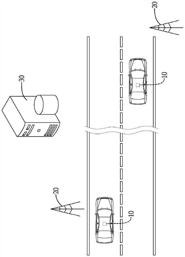
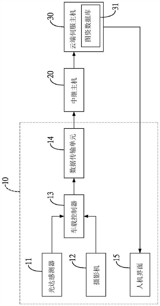
[0042]Please refer tofigure 1 andfigure 2 Shown here is a schematic diagram of the system of the present invention, which includes a vehicle-end device 10 installed on each vehicle, a relay host 20 scattered in a road environment, and a cloud server host 30.

[0043]Each vehicle-end device 10 on each vehicle includes a LiDAR sensor 11, a camera 12, a vehicle controller 13, a data transmission unit 14 and a human-machine interface 15. The LiDAR sensor 11 is connected to the on-board controller 13 for sensing the environment around the vehicle to generate point cloud data. The camera 12 is connected to the on-board controller 13 for capturing the environment around the vehicle to generate image data. The on-board controller 13 sends the point cloud data and image data to the outside through the data transmission unit 14. The on-board controller 13 is preset with a unique vehicle identification code (Identity, ID) for the vehicle Identify the vehicle among multiple vehicles. The data tran...


PUM


Abstract

The invention relates to a method and a system for establishing dynamic map data capable of providing environmental information, the system comprises a cloud servo host, a plurality of relay hosts erected around the environment, and a plurality of vehicle end devices respectively arranged on different vehicles, each vehicle end device comprises a LiDAR sensor and a camera, so as to sense the surrounding environment of the vehicle to generate point cloud data and image data; the point cloud data of different vehicles are transmitted to the adjacent relay host, the relay host executes a multi-vehicle integration calculation and combines the point cloud data of each vehicle to obtain three-dimensional coordinate information of surrounding environment objects of the vehicles, and the cloud servo host establishes dynamic map data information according to the three-dimensional coordinate information and returns the dynamic map data information to each vehicle. By sharing the sensing data ofdifferent vehicles, the sensing range of the vehicles to the surroundings can be improved, and the number of sensing dark zones or blind zones can be reduced.

Description

Technical field[0001]The present invention is a method for automatically identifying environmental information, especially a method for identifying obstacles by combining lidar information and image information.Background technique[0002]As the development progress of contemporary artificial intelligence (AI) and mechanical learning can be said to be rapid compared to the past, many international companies have used this rapidly changing learning technology to invest in self-driving car research and development. The self-driving car system mounted on the vehicle detects the surrounding environment of the vehicle through multi-sensing fusion technology, executes decision-making judgments based on the sensing results, and finally controls the vehicle to respond based on the decision-making results.[0003]In the sensing part, if all the sensed information is obtained by sensing the surrounding environment by the sensor of the vehicle itself, that is to say, only a single vehicle senses t...

Claims


Application Information

Patent Timeline
Patent Type & Authority Applications(China)
IPC IPC(8): G07C5/08G07C5/00H04W4/38H04W4/44H04W4/46G01S17/931G01S17/02H04W88/04
CPCG07C5/0866G07C5/008H04W4/44H04W4/46H04W4/38H04W88/04
Inventor 林轩达王正楷施淳耀
Owner AUTOMOTIVE RES & TESTING CENT
Why Eureka
Try Eureka