Unmanned aerial vehicle target tracking method and device and unmanned aerial vehicle

A technology for tracking targets and UAVs, applied in the field of UAV target tracking, which can solve the problems of poor target tracking effect and achieve the effect of improving the tracking effect

Active Publication Date: 2021-02-19
COMP APPL TECH INST OF CHINA NORTH IND GRP
View PDF25 Cites 8 Cited by
  • Summary
  • Abstract
  • Description
  • Claims
  • Application Information

AI Technical Summary

Problems solved by technology

[0004] However, considering that the spatial position of the target usually changes, the target tracking effect is poor when relying solely on feature points to identify the target.

Method used


Image

  • Unmanned aerial vehicle target tracking method and device and unmanned aerial vehicle
  • Unmanned aerial vehicle target tracking method and device and unmanned aerial vehicle
  • Unmanned aerial vehicle target tracking method and device and unmanned aerial vehicle

Examples


Embodiment 1

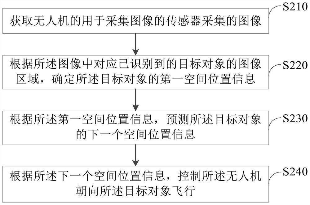
[0035] figure 2 is a schematic flowchart of a method for tracking a target by a drone according to an embodiment. In this embodiment, the method for tracking a target by a UAV may include the following steps S210-S240.

[0036] Step S210, acquiring an image collected by a sensor of the drone for collecting images. For example, the image may be an image collected by the photoelectric pod 401 described above.

[0037] Step S220: Determine the first spatial position information of the target object according to the image area corresponding to the recognized target object in the image.

[0038] In detail, the target object to be tracked can be identified according to the image collected by the sensor, and the target object can be locked after the target object is identified. And, based on the image corresponding to the recognized target object, combined with the image collected by the sensor after the target object is recognized, the target object is tracked.
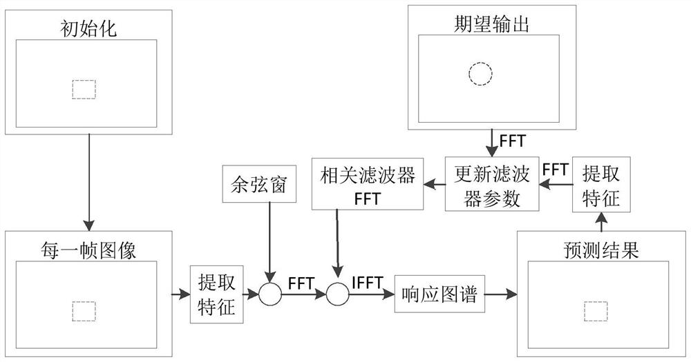
[0039] In this...

Embodiment 2

[0066] Based on the content disclosed in Embodiment 1 above, in the process of realizing the tracking target of the UAV, the UAV can also locate itself. In one example, please refer to Figure 4 , The method for tracking a target by a UAV may further include the following steps S410-S440.

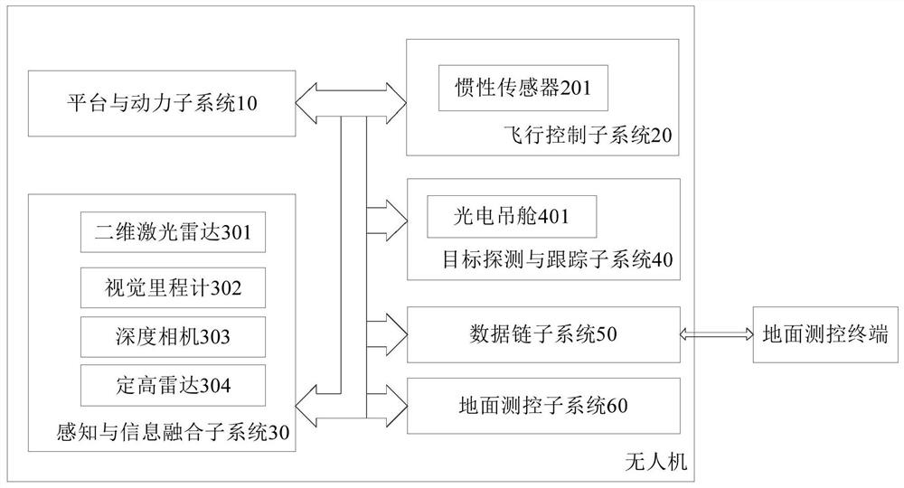
[0067] In one embodiment, taking the underground garage environment as an example, in the underground garage environment, the UAV can use the inertial sensor 201, the two-dimensional laser radar 301, the visual odometer 302, the depth camera 303, and the fixed height radar 304 to perform multiple Sensor fusion positioning. Among them, the schematic diagram of the interactive interface of the UAV autonomous positioning software can be as follows: Figure 5 shown.

[0068] Such as Figure 5 As shown, ROS can be installed in the above-mentioned airborne computer, and ROS can be equipped with laser height determination driver package, laser radar driver package, camera driver package and MA...

Embodiment 3

[0100] Based on the content disclosed in Embodiment 1 above, in the process of realizing the UAV tracking the target, the UAV can also fly with obstacle avoidance. In one example, please refer to Figure 6 , the above step S240 may include the following steps S610-S640. The unmanned aerial vehicle can perform the step of obstacle avoidance flight and the step of target tracking respectively and simultaneously.

[0101] Step S610, constructing a first map of the space environment where the UAV is located.

[0102] It can be based on the starting position (such as the spatial position of the UAV) and the destination position of the UAV obstacle avoidance mission, combined with the perception of each sensor on the UAV (such as the above-mentioned two-dimensional laser radar 301, visual odometer 302, etc.) The acquired environmental data is used to build a map of the space environment where the UAV is located. Among them, the spatial position of the UAV can be determined accord...


PUM


Abstract

The invention provides an unmanned aerial vehicle target tracking method and device and an unmanned aerial vehicle. The method comprises the following steps: acquiring an image acquired by a sensor for acquiring the image of an unmanned aerial vehicle; determining first spatial position information of the target object according to an image area, corresponding to the recognized target object, in the image; predicting the next spatial position information of the target object according to the first spatial position information; and controlling the unmanned aerial vehicle to fly towards the target object according to the next spatial position information. According to the method of the embodiment, the target tracking effect can be improved.

Description

technical field [0001] The present disclosure relates to the technical field of UAV target tracking, and more specifically, to a method and device for UAV tracking a target, and the UAV. Background technique [0002] With the advancement of the urbanization process of human society, the contradiction between the explosive growth of urban population and the limited surface area continues to rise, which makes the urban combat system expand to the underground space. With the increasing status of underground space in urban combat, it is particularly important to realize the reconnaissance and detection of underground space targets. In underground space, using drones to search, identify, lock and track targets has a wide range of applications. In order to realize the normal execution of tasks of UAVs in underground space, it is necessary to solve the problem of target tracking of UAVs in underground spaces. [0003] At present, the target can be tracked according to preset feat...

Claims


Application Information

Patent Timeline
Patent Type & Authority Applications(China)
IPC IPC(8): G01C21/00G01C21/16G06K9/62G06F17/14G06N3/04G06N3/08
CPCG01C21/005G01C21/165G06F17/142G06N3/08G06V20/625G06N3/045G06F18/214
Inventor 赵小川董忆雪李陈徐凯宋刚刘华鹏郑君哲邵佳星史津竹王子彻陈路豪马燕琳冯云铎
Owner COMP APPL TECH INST OF CHINA NORTH IND GRP
Why Eureka
Try Eureka