Urban path image generation method combining questionnaire survey and streetscape pictures

A path and image technology, applied in structured data retrieval, prediction, instrumentation, etc., can solve problems such as non-objectivity, too macroscopic and abstract statistics

Active Publication Date: 2021-02-19
SOUTH CHINA UNIV OF TECH +1
View PDF7 Cites 1 Cited by
  • Summary
  • Abstract
  • Description
  • Claims
  • Application Information

AI Technical Summary

Problems solved by technology

In the existing schemes, traditional methods such as cognitive maps rely more on human subjective judgment, and the results obtained are not objective. However, although new data methods such as network open data reduce randomness to a certain extent, they can reflect the image of the city more reasonably. However, the statistics obtained are too macroscopic and abstract. In view of this, urban image research needs a comprehensive, efficient and objective method to make up for the above shortcomings

Method used


Image

  • Urban path image generation method combining questionnaire survey and streetscape pictures
  • Urban path image generation method combining questionnaire survey and streetscape pictures
  • Urban path image generation method combining questionnaire survey and streetscape pictures

Examples


Embodiment

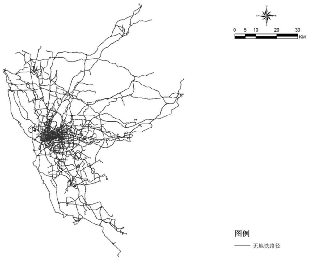
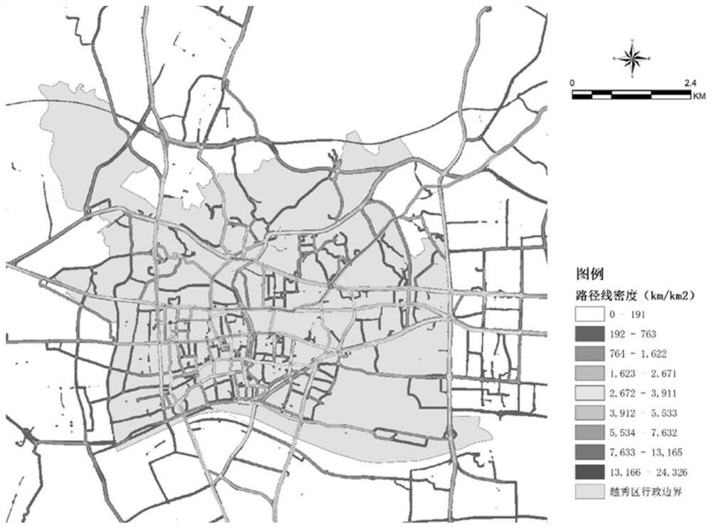
[0078] This embodiment adopts an application example and takes Yuexiu District, Guangzhou City, Guangdong Province as the research object for practice.

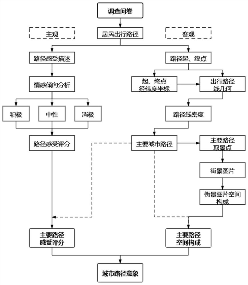
[0079] Such as figure 1 As shown, the present embodiment provides a method for generating city path images combining questionnaire surveys and street view images, which specifically includes the following steps:

[0080] 1) Data collection and collation, design, distribution and recycling of questionnaires, to obtain the starting point, end point, mode of transportation and feelings along the journey of residents in the study area;

[0081] 1.1) Design questionnaire: investigate the daily travel route and feelings along the way of residents in Yuexiu District, mainly record the starting point, passing point and end point of the route, and record the transportation mode and feeling along the way between each two points.

[0082] 1.2) Questionnaire distribution and recycling: After distributing questionnaires to residents in Y...


PUM


Abstract

The invention discloses an urban path image generation method combining questionnaire survey and street view pictures, and the method comprises the steps: recording the start and end points of travelof residents and the feeling along the way in a given region range; capturing longitude and latitude coordinates of a starting point and an ending point and generating all travel paths; obtaining a main travel path of residents in a given territorial range by utilizing a linear density analysis method, and uniformly obtaining view finding points of street view pictures on the main path and tangentangles of the view finding points on the path by adopting an equidistant sampling method; dividing factors such as sky, buildings, afforestation and roads on the streetscape picture, calculating to obtain an average sky view rate, a building view rate, an afforestation view rate and a road view rate of the main path, and forming a space composition of the main path; integrating the main path space composition of the research area and the main path feeling score of residents to form an urban path image. Objective reality of a city and subjective feelings of people are comprehensively considered, and a research method of a city image is expanded.

Description

technical field [0001] The invention relates to the technical field of urban planning and design analysis, in particular to a method for generating urban path images combined with questionnaires and street view pictures. Background technique [0002] The five spatial elements of urban imagery: region, boundary, node, path, and sign, and take the five elements as the basic method of recognizing urban imagery, and attach importance to the perception of urban space environment by individual residents or groups. An important example of structure. In the existing schemes, traditional methods such as cognitive maps rely more on human subjective judgment, and the results obtained are not objective. However, although new data methods such as network open data reduce randomness to a certain extent, they can reflect the image of the city more reasonably. However, the statistics obtained are too macroscopic and abstract. In view of this, urban image research needs a comprehensive, eff...

Claims


Application Information

Patent Timeline
Patent Type & Authority Applications(China)
IPC IPC(8): G06Q10/04G06Q50/26G06F16/29G06F16/9537
CPCG06Q10/043G06Q50/26G06F16/29G06F16/9537
Inventor 邓昭华王世福赵银涛朱雅琴陈丹彤
Owner SOUTH CHINA UNIV OF TECH
Why Eureka
Try Eureka