A fast maneuvering control method for multi-point imaging of low-orbit optical remote sensing satellites

An optical remote sensing and satellite technology, applied in the field of aerospace, to achieve the effects of improving utilization, reducing maneuvering time, and high-precision attitude stability

Active Publication Date: 2022-04-19
CHANGGUANG SATELLITE TECH CO LTD
View PDF12 Cites 0 Cited by
  • Summary
  • Abstract
  • Description
  • Claims
  • Application Information

AI Technical Summary

Problems solved by technology

The above methods fail to achieve high-precision and fast maneuvering control of optical remote sensing satellites under the condition that the satellite reaction flywheel torque and angular momentum are limited

Method used


Image

  • A fast maneuvering control method for multi-point imaging of low-orbit optical remote sensing satellites
  • A fast maneuvering control method for multi-point imaging of low-orbit optical remote sensing satellites
  • A fast maneuvering control method for multi-point imaging of low-orbit optical remote sensing satellites

Examples


Embodiment Construction

[0054] The present invention will be described in further detail below in conjunction with the accompanying drawings and embodiments.

[0055] A low-orbit optical remote sensing satellite multi-point imaging fast maneuvering control method, the method includes the following steps:

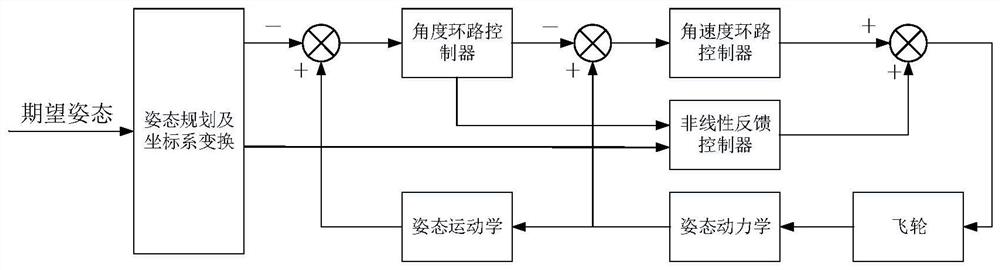
[0056] Step 1: Carry out kinematic dynamics modeling for low-orbit optical remote sensing satellites: define F I Indicates the inertial coordinate system, F B Indicates the satellite body coordinate system; the satellite body coordinate system F B Relative to the inertial coordinate system F I The angular velocity is expressed as body coordinate system F B Relative inertial coordinate system F I The pose of is represented as a unit quaternion and satisfy the constraints where q 0 is the scalar part of the quaternion Q, q=(q 1 ,q 2 ,q 3 ) is the vector part of the quaternion Q, Represents an n-dimensional real vector space, and the kinematics and dynamics equations of the satellite a...


PUM


Abstract

A low-orbit optical remote sensing satellite multi-point imaging fast maneuvering control method belongs to the field of aerospace technology, which realizes that the satellite attitude can be controlled to the expected value in the shortest time under the condition that the satellite reaction flywheel moment and its angular momentum are limited, so that the optical load can be imaged. state target. The method includes: kinematics dynamic modeling of low-orbit optical remote sensing satellite; satellite attitude planning method; transforming the attitude planning result from the orbital coordinate system to the inertial coordinate system; combining the attitude planning information to establish the satellite error kinematics dynamic equation ; The attitude of the satellite is divided into inner and outer loops, and a controller is established to realize the fast maneuvering control of multi-point imaging of low-orbit optical remote sensing satellites. This method has both rapid attitude maneuvering and high-precision attitude stability. During the attitude maneuvering process, the satellite attitude can smoothly converge to the planned attitude. The control method is simple in structure, easy to implement, and can be applied in engineering practice.

Description

technical field [0001] This patent belongs to the field of aerospace technology, and specifically relates to a fast maneuvering control method for multi-point imaging of low-orbit optical remote sensing satellites. Background technique [0002] With the rapid development of the low-orbit satellite constellation industry, low-orbit optical remote sensing satellites have become the backbone of the remote sensing information industry due to their high-quality, large-width imaging capabilities. The maneuverability and stability of the satellite attitude control system directly affect the imaging time and quality of the satellite, and are one of the important indicators of the optical remote sensing satellite system. In the field of satellite control engineering, the stability and rapidity of the system are contradictory, and the general control method is difficult to achieve both. Therefore, it is of great significance to study the fast maneuvering control method of multi-point...

Claims


Application Information

Patent Timeline
Patent Type & Authority Patents(China)
IPC IPC(8): B64G1/28
CPCB64G1/285
Inventor 曲友阳刘萌萌李峰童鑫戴路
Owner CHANGGUANG SATELLITE TECH CO LTD
Why Eureka
Try Eureka