
Method for inverting underground goaf position parameters by fusing InSAR and PSO

A goaf and inversion technology, applied in the direction of measuring devices, radio wave reflection/re-radiation, instruments, etc., can solve problems such as lack of survey locations, low efficiency, and complex implementation of geophysical exploration technology

Active Publication Date: 2021-03-16
CHINA UNIV OF MINING & TECH
View PDF9 Cites 3 Cited by
  • Summary
  • Abstract
  • Description
  • Claims
  • Application Information

AI Technical Summary

Problems solved by technology

Manual inspections are time-consuming and laborious, lack specific investigation locations, and cannot achieve real-time monitoring
The implementation of geophysical prospecting technology is complex and expensive, and the detection area is too small, the flexibility is not enough, the efficiency is low, and the detection accuracy is low when the mining depth is large
InSAR technology has the advantages of all-weather, all-time, wide coverage, low cost, and high precision. Applying this technology to mining monitoring in mining areas can reduce monitoring costs. Due to its large coverage, it can achieve large-scale monitoring and improve It improves the regulatory efficiency, but this technology can only obtain the surface subsidence, and it is difficult to obtain the location parameters of underground mining

Method used


Image

  • Method for inverting underground goaf position parameters by fusing InSAR and PSO
  • Method for inverting underground goaf position parameters by fusing InSAR and PSO
  • Method for inverting underground goaf position parameters by fusing InSAR and PSO

Examples


Embodiment Construction

[0056] The present invention will be described in further detail below in conjunction with specific implementation process:

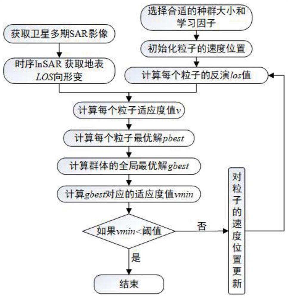
[0057] Such as figure 1 As shown, the method for inverting the location parameters of underground mined-out areas by integrating InSAR and PSO in the present invention first uses InSAR synthetic aperture radar interferometry technology to obtain the deformation information of the mine area radar line of sight to the surface, which is recorded as LOS; According to the "Code for Coal Pillar Retention and Pressure Coal Mining in Buildings, Water Bodies, Railways and Main Shafts" to determine the estimated parameters of the study area by probability integration method; The number of deformation points, according to the density of surface deformation points, determines the number of deformation points participating in goaf inversion. The number of deformation points participating in goaf inversion is input into the classic PSO particle swarm optimization alg...


PUM


Abstract

The invention discloses a method for inverting underground goaf position parameters by fusing InSAR and PSO, which is suitable for the field of mineral geological monitoring and protection. The methodcomprises steps of utilizing an InSAR method to obtain ground surface deformation of the mining area radar sight line, determining a value range of goaf parameters, initializing the position and speed information of each individual in the particle swarm, substituting the position coordinates of the particle swarm into a probability integral model to obtain vertical subsidence and east-west and north-south horizontal movement of the earth surface, and converting deformation into LOS-direction deformation according to radar imaging geometry, substituting the converted LOS directional surface deformation and the LOS directional surface deformation calculated by the InSAR into a fitness function to calculate a fitness value, and obtaining and recording an optimal solution of each particle anda globally optimal solution of a group, and solving a fitness value corresponding to the optimal solution of the population in iteration. The method is easy to operate, the effect of inverting the position parameters of the underground goaf is good, technical support can be provided for illegal mining of underground coal resources and inversion of the position of a coal fire area, and meanwhile the application space of the InSAR technology is expanded.

Description

technical field [0001] The invention relates to a method for retrieving location parameters of underground goafs, in particular to a method for retrieving location parameters of underground goafs by integrating InSAR and PSO, which is suitable for mining subsidence monitoring in mining areas, and belongs to the field of geographic monitoring. [0002] technical background [0003] Our country has a vast territory and has various natural resources, among which coal resources are the energy that our country mainly relies on now. Because of this, in many areas of our country there are cases of illegal mining of coal resources. On the one hand, this causes a waste of national resources and damages state-owned assets; The safety of life and property of mines can also be caused, and it will also cause mine geological environmental disasters such as aquifer damage, landslides, surface subsidence, and damage to buildings and structures. Therefore, in order to standardize the behavio...

Claims


Application Information

Patent Timeline
IPC IPC(8): G01S13/90G01S13/88G06N3/00
CPCG01S13/9023G01S13/885G06N3/006
Inventor 范洪冬庄会富李腾腾谭志祥邓喀中
Owner CHINA UNIV OF MINING & TECH
Learn More