Unlock instant, AI-driven research and patent intelligence for your innovation.

Method and device for realizing administrative region aggregation based on leaflet

An administrative area and administrative technology, applied in the field of network communication, can solve the problems of overlapping points and omissions of icons, and achieve the effect of wide application range and fast operation speed

Pending Publication Date: 2021-03-16
青岛以萨数据技术有限公司 +2
View PDF4 Cites 0 Cited by
  • Summary
  • Abstract
  • Description
  • Claims
  • Application Information

AI Technical Summary

Problems solved by technology

[0006] The purpose of the embodiments of the present invention is to provide a method and device for achieving administrative region aggregation based on leaflet, so as to overcome the defects in the prior art that require multiple complex distance calculations and are prone to overlapping icons or missing points

Method used


Image

  • Method and device for realizing administrative region aggregation based on leaflet
  • Method and device for realizing administrative region aggregation based on leaflet

Examples


Embodiment Construction

[0032] Embodiments of the technical solutions of the present invention will be described in detail below in conjunction with the accompanying drawings. The following examples are only used to illustrate the technical solution of the present invention more clearly, so they are only examples, and should not be used to limit the protection scope of the present invention.

[0033] It should be noted that, unless otherwise specified, the technical terms or scientific terms used in this application shall have the usual meanings understood by those skilled in the art to which the present invention belongs.

[0034] It should be noted that leaflet is an open source map Javascript library for interactive maps designed for mobile devices.

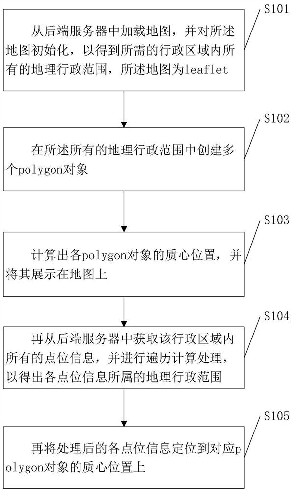
[0035] Please refer to figure 1 , is a method for implementing administrative region aggregation based on leaflet provided by an embodiment of the present invention, and the method includes:

[0036] S101. Load a map from a backend server, and init...


PUM


Abstract

The invention discloses a method and device for realizing administrative region aggregation based on leaflet, and the method comprises the steps: loading a map from a rear-end server, and initializingthe map, so as to obtain all needed geographical administrative ranges in an administrative region, the map being leaflet; creating a plurality of polygon objects in all geographic administrative ranges; calculating the position of the mass center of each polygon object; acquiring all point location information in the administrative region from a back-end server, and performing traversal calculation processing to obtain a geographical administrative range to which each piece of point location information belongs; and then, locating the processed information of each point location to the masscenter position of the corresponding polygon object. The method has the advantages that the leaflet is used, the operation speed is high, complex distance calculation and repeated iterative processingare avoided, the situation of clustering icon overlapping or point location omission is avoided, and the method is suitable for most application scenes and wide in application range.

Description

technical field [0001] The invention relates to the technical field of network communication, in particular to a method and device for realizing administrative region aggregation based on leaflet. Background technique [0002] At present, K-means clustering is a well-known algorithm for dividing clusters. Due to its simplicity and efficiency, it has become the most widely used of all clustering algorithms. Given a set of data points and the required number of clusters k, k is determined by the user, and the k-means algorithm repeatedly divides the data into k clusters according to a certain distance function. [0003] Each map API and plug-in basically has its own packaged and written clustering API or plug-in. At present, most of them use the respective APIs and plug-ins of these map manufacturers. But there are the following disadvantages: [0004] 1. Performance issues. In the case of a large amount of data, the algorithm needs multiple iterations to complete, which con...

Claims


Application Information

Patent Timeline
IPC IPC(8): G06F16/29G06K9/62G06Q50/26
CPCG06F16/29G06Q50/26G06F18/23
Inventor 赵正航李凡平王成
Owner 青岛以萨数据技术有限公司
Features
  • R&D
  • Intellectual Property
  • Life Sciences
  • Materials
  • Tech Scout
  • Unparalleled Data Quality
  • Higher Quality Content
  • 60% Fewer Hallucinations
Learn More