Tidal flat digital elevation model construction method and system

A technology of digital elevation model and construction method, which is applied in the field of tidal flat digital elevation model construction, can solve the problems of low precision of water edge, large difference between spectrum and texture, and division of water edge system, and achieves the effect of high precision

Pending Publication Date: 2021-03-16
中国自然资源航空物探遥感中心
View PDF0 Cites 0 Cited by
  • Summary
  • Abstract
  • Description
  • Claims
  • Application Information

AI Technical Summary

Problems solved by technology

However, the instantaneous waterline is affected by factors such as tides, weather, and beach surface when the satellite passes, and the spectrum and texture in the image are quite different. It is difficult to guarantee the accuracy of waterline extraction based on a single method, which affects Tidal flat DEM inversion results
Although Wu Di et al. proposed a water edge extraction model based on multi-source and multi-algorithms, they did not systematically divide the water edge, and the accuracy of water edge extraction was low, and they did not apply it to the construction of tidal flat DEM.

Method used


Image

  • Tidal flat digital elevation model construction method and system
  • Tidal flat digital elevation model construction method and system
  • Tidal flat digital elevation model construction method and system

Examples


Embodiment Construction

[0064] The following will clearly and completely describe the technical solutions in the embodiments of the present invention with reference to the accompanying drawings in the embodiments of the present invention. Obviously, the described embodiments are only some, not all, embodiments of the present invention. Based on the embodiments of the present invention, all other embodiments obtained by persons of ordinary skill in the art without making creative efforts belong to the protection scope of the present invention.

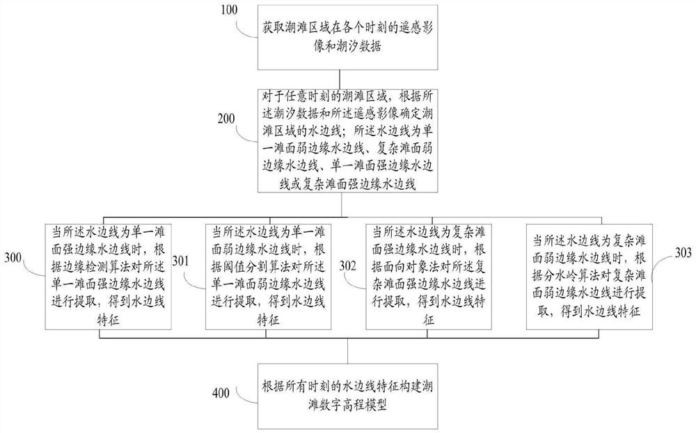
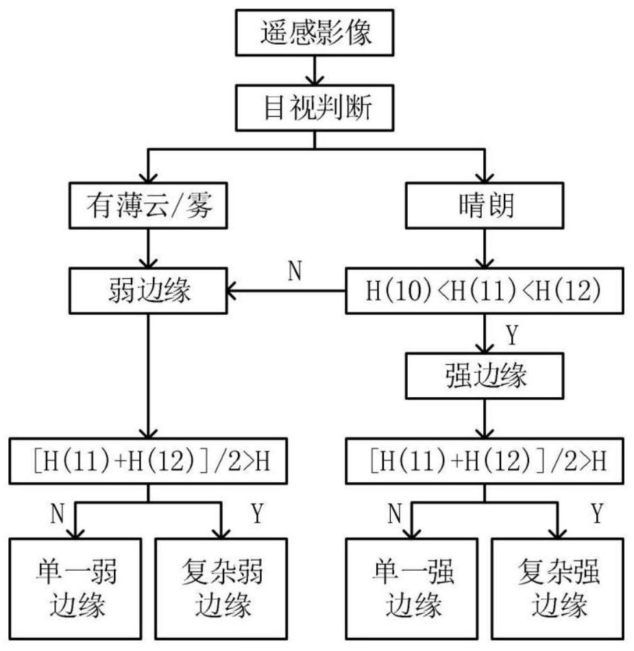
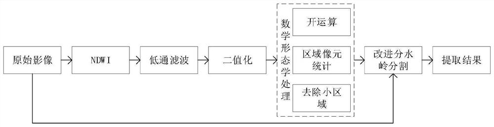
[0065] The purpose of the present invention is to provide a tidal flat digital elevation model construction method and system, which can classify water edges based on tidal data, and extract different types of water edges based on multiple algorithms according to the classification results, thereby improving the extraction of water edges Accuracy, thus improving the accuracy of tidal flat DEM construction.

[0066] In order to make the above objects, features ...


PUM


Abstract

The invention relates to a tidal flat digital elevation model construction method and system. The method comprises the steps of obtaining remote sensing images and tide data of a tidal flat area; determining a waterline of a tidal flat area according to the tide data and the remote sensing image, wherein the water side lines are single beach surface weak edge water side lines, complex beach surface weak edge water side lines, single beach surface strong edge water side lines or complex beach surface strong edge water side lines; extracting the single beach surface strong edge waterline according to an edge detection algorithm to obtain waterline features; extracting the single beach face weak edge waterline according to a threshold segmentation algorithm to obtain waterline features; extracting the complex beach surface strong edge waterline according to an object-oriented method to obtain waterline features; extracting the weak edge waterlines of the complex beach surface according toa watershed algorithm to obtain waterline features; and constructing a tidal flat digital elevation model according to the waterside line characteristics. According to the invention, the extraction precision of the waterline can be improved, so that the accuracy of model construction is improved.

Description

technical field [0001] The invention relates to the field of digital model construction, in particular to a tidal flat digital elevation model construction method and system. Background technique [0002] The muddy tidal flat usually refers to the area between the average spring high tide line and the average spring tide low tide line, also known as the intertidal zone. In my country, about a quarter of the coast is silty coast, and obtaining the silt tidal flat topography is of great significance for the study of shoreline changes, ecological changes of coastal zones and coastal engineering construction. Affected by many factors such as waves, sediment, coastal currents, and geology, muddy tidal flats have the characteristics of wide area, flat water and frequent changes, which makes the ground survey and topographic mapping in this area difficult and costly , and there is a certain risk. Remote sensing technology has the characteristics of high timeliness, large range, a...

Claims


Application Information

Patent Timeline
IPC IPC(8): G06T17/05G06T17/20G06T7/13G06T7/136G06T7/12G06T7/155
CPCG06T17/05G06T17/20G06T7/13G06T7/136G06T7/12G06T7/155G06T2207/20152
Inventor 陈洁李天祺赵政张文凯吴芳张宗贵
Owner 中国自然资源航空物探遥感中心
Why Eureka
Try Eureka