A grid map positioning method based on point cloud registration

A raster map and positioning method technology, applied in image data processing, 2D image generation, geographic information database and other directions, can solve the problems of inaccurate AMCL estimated pose and slippage, and achieve fast and efficient positioning and good stability. , the effect of avoiding positioning errors

Active Publication Date: 2022-06-24
哈尔滨工业大学芜湖机器人产业技术研究院
View PDF0 Cites 0 Cited by
  • Summary
  • Abstract
  • Description
  • Claims
  • Application Information

AI Technical Summary

Problems solved by technology

[0004] Using odometer data, there may be slippage, and it uses the scores of all particles as weights to calculate the weighted pose mean of the particle swarm, resulting in inaccurate AMCL estimated poses.

Method used


Image

  • A grid map positioning method based on point cloud registration
  • A grid map positioning method based on point cloud registration
  • A grid map positioning method based on point cloud registration

Examples


Embodiment Construction

[0028] The specific embodiments of the present invention will be described in further detail below with reference to the accompanying drawings, through the description of the embodiments, to help those skilled in the art to have a more complete, accurate and in-depth understanding of the inventive concept and technical solutions of the present invention.

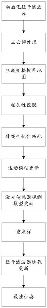
[0029] figure 1 A flowchart of a method for locating a grid map based on point cloud registration provided by the embodiment of the present invention, the method specifically includes the following steps:

[0030] Step 1) Initialize the particle filter: build a particle filter, and randomly distribute particles according to the Gaussian model near the initial pose to ensure that the particles fall into the free area of ​​the global map. The free area is the area where the lidar detects no obstacles. The free area is the valid area of ​​the global map;

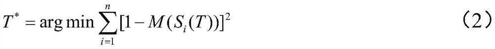
[0031] Step 2) Point cloud preprocessing: use statistical probability f...


PUM


Abstract

The invention discloses a grid map positioning method based on point cloud registration. The candidate pose of is used as the initial pose; the objective function T is constructed for the projection points of the laser frames P1 and P2 in the grid map * , iteratively outputs the optimal pose; the optimal pose is sent to the odometer, and the odometer completes the prediction of all particle poses; according to the observation data of the particle position, the particle weight and the total weight of the particle are calculated by using the likelihood domain; according to the particle The weight screens the particles, copies the high-weight particles, discards the low-weight particles, adds random particles, updates the particle distribution, and compares and updates the maximum weight of the particle cluster; detects whether the maximum weight of the particle cluster is greater than the set weight threshold, if detected If the result is yes, then the best pose at this time is obtained. To a certain extent, it overcomes the slippage problem of using odometer.

Description

technical field [0001] The invention belongs to the technical field of positioning, and more particularly, the invention relates to a grid map positioning method based on point cloud registration. Background technique [0002] At present, the commonly used mobile robot positioning and navigation methods mainly include electromagnetic navigation, tape navigation, two-dimensional code navigation, laser navigation and so on. Navigation methods such as electromagnetic navigation and tape navigation require maintenance, have poor path flexibility, are not suitable for complex paths, and cannot achieve precise positioning. At present, the simultaneous localization and map construction (SLAM) technology of mobile robots has become a hot issue in the research of robot positioning and navigation. The localization method based on particle filter has become the mainstream. It updates the weight of the particle according to the observation results of the sensor and performs resampling,...

Claims


Application Information

Patent Timeline
Patent Type & Authority Patents(China)
IPC IPC(8): G06F16/29G06T11/00G01C21/00G01C21/20
CPCG06F16/29G06T11/001G01C21/20G01C21/005
Inventor 陈智君伍永健郝奇
Owner 哈尔滨工业大学芜湖机器人产业技术研究院
Why Eureka
Try Eureka