Supercharge Your Innovation With Domain-Expert AI Agents!

Big data geographic information visualization method and system and storage medium

A geographic information and big data technology, applied in the field of big data geographic information visualization methods, systems and storage media, can solve the problems that users cannot understand the required data supplementation methods, and users cannot visually view the required query areas.

Active Publication Date: 2021-04-13
湖南虹康规划勘测咨询有限公司
View PDF9 Cites 5 Cited by
  • Summary
  • Abstract
  • Description
  • Claims
  • Application Information

AI Technical Summary

Problems solved by technology

[0004] Regarding the related technologies mentioned above, the inventor believes that there are the following defects: once the query area required by the user cannot be visualized due to the lack of important data related to the visualization technology, the user cannot understand the supplementary method of the data he needs, resulting in the user being unable to visualize The query area required for viewing

Method used


Image

  • Big data geographic information visualization method and system and storage medium
  • Big data geographic information visualization method and system and storage medium
  • Big data geographic information visualization method and system and storage medium

Examples


Embodiment Construction

[0047]The present application will be further described below with reference to the accompanying drawings.

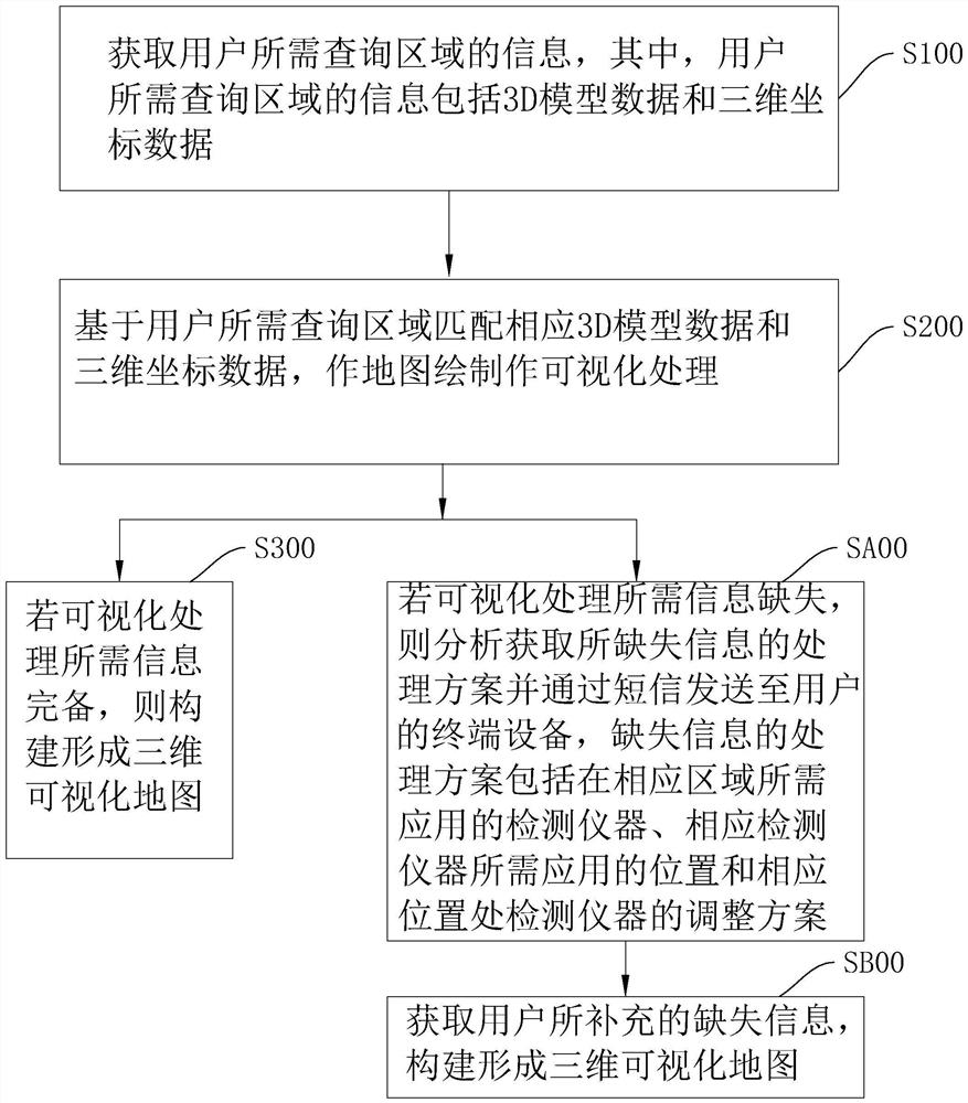
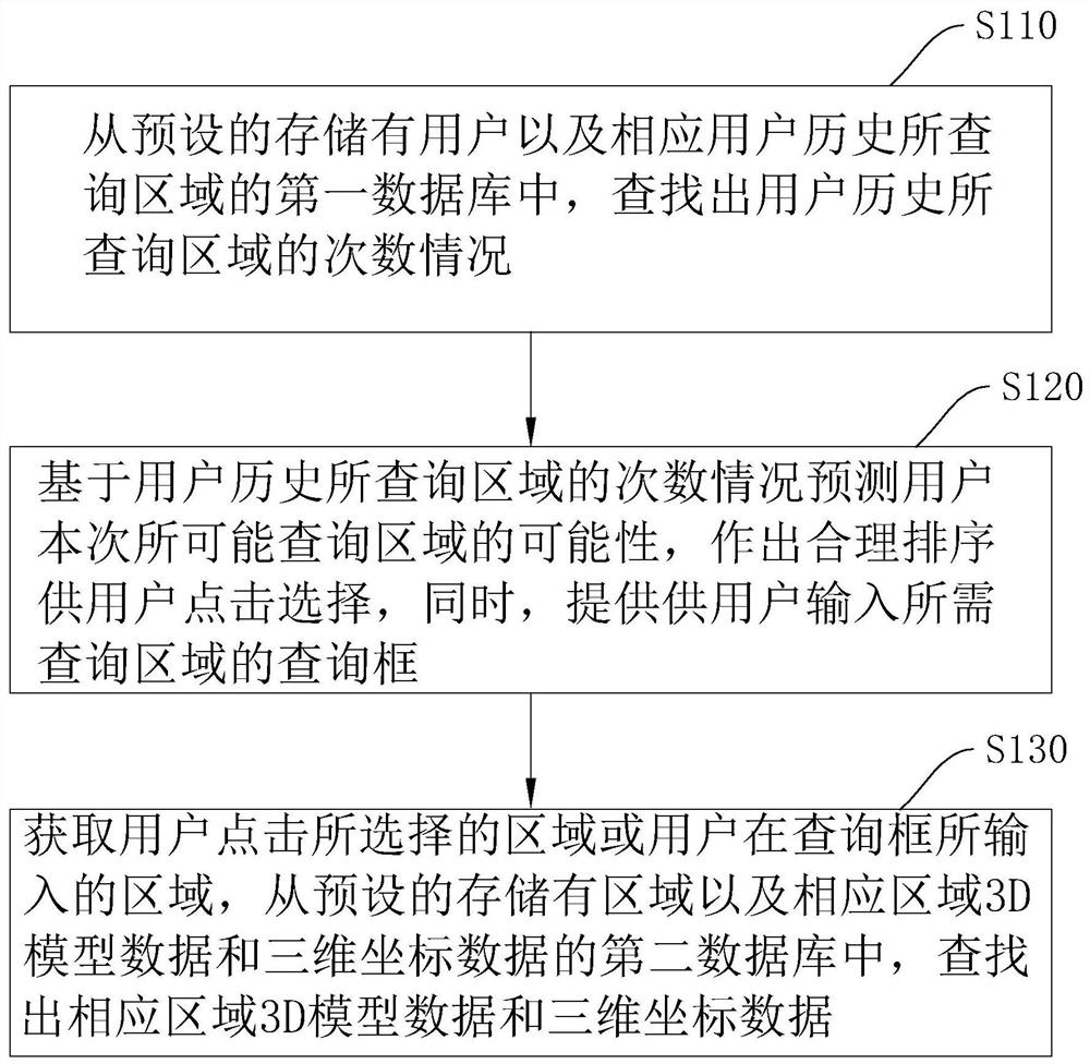
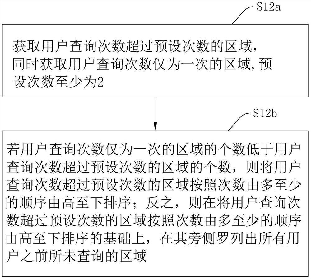
[0048]Referfigure 1 For a large data geographic information visualization method disclosed in the present application, step S100, step S200, step S300, step SA00, step SB00, wherein step S300 is run in parallel with step SA00.

[0049]In step S100, information of the user's query area is acquired, wherein the information of the user's query area includes 3D model data and three-dimensional coordinate data.

[0050]Among them, the three-dimensional coordinate data mentioned in step S100 mainly by obtaining the GEO data in accordance with the reference data conversion, GEO data is geospatial data, and GEO data mainly refers to geospatial, used to define, describe the geographic element in space. Data types in the shape of the appearance shape. In addition to data such as latitude and longitude coordinates such as graphics, GEO data can also be customized to expand other data information...


PUM


Abstract

The invention relates to a big data geographic information visualization method, a big data geographic information visualization system and a storage medium, relates to the technical field of visualization, and solves the problem that when important data related to a visualization technology is lacked and geographic information visualization cannot be realized, a user cannot know a supplementary mode of supplementary data required by the user, and the user experience. The method comprises the following steps: if information required by visual processing is missing, analyzing and acquiring a processing scheme of the missing information and sending the processing scheme to terminal equipment of a user through a short message, wherein the missing information processing scheme comprises a detection instrument required to be applied to a corresponding area, a position required to be applied by the corresponding detection instrument and an adjustment scheme of the detection instrument at the corresponding position; and acquiring missing information supplemented by the user, and constructing and forming a three-dimensional visual map. According to the invention, when the geographic information of the area required to be queried by the user cannot be visually viewed, the user can be timely notified of the processing scheme of the missing information.

Description

Technical field[0001]The present application relates to the field of visualization, in particular, relates to a large data geographic information visualization method, system, and storage medium.Background technique[0002]With data analysis, data mining and other industries, the rapid development of the field, data visualization in various industries, especially large amounts of data is in the development trend of changing, changing, and updated. With the continuous segment of the data visualization market, the custom demand for various data visualization applications is frequent. For the specific market, demand type technology, architecture continuously, based on the geographic information system's large data visualization scheme, due to its space, time Data analysis value of dimensions embodied in business, has gradually been widely used in various industries and scenes.[0003]There is a large data geographic information visualization system. When users want to visualize geographic ...

Claims


Application Information

Patent Timeline
IPC IPC(8): G06F16/2457G06F16/2458G06F16/26G06F16/27G06F16/29G06T17/05
CPCG06T17/05G06F16/2457G06F16/2474G06F16/26G06F16/27G06F16/29
Inventor 肖满红谢红波皮东兆阳张弛
Owner 湖南虹康规划勘测咨询有限公司
Features
  • R&D
  • Intellectual Property
  • Life Sciences
  • Materials
  • Tech Scout
  • Unparalleled Data Quality
  • Higher Quality Content
  • 60% Fewer Hallucinations
Learn More