Wind cloud satellite remote sensing surveying and mapping data management system

A data management system and satellite remote sensing technology, which is applied in the field of Fengyun satellite remote sensing surveying and mapping data management system, can solve the problems of scattered data sources, low data utilization rate, and inaccurate classification, and achieve the effect of improving utilization efficiency and enhancing accuracy

Pending Publication Date: 2021-04-13
胡友彬
View PDF0 Cites 1 Cited by
  • Summary
  • Abstract
  • Description
  • Claims
  • Application Information

AI Technical Summary

Problems solved by technology

[0003] In the existing Fengyun satellite remote sensing surveying and mapping data management system, the various data sources are scattered, and the classification is not accurate enough, resulting in low data utilization in the actual process of data application

Method used


Image

  • Wind cloud satellite remote sensing surveying and mapping data management system
  • Wind cloud satellite remote sensing surveying and mapping data management system
  • Wind cloud satellite remote sensing surveying and mapping data management system

Examples


Embodiment

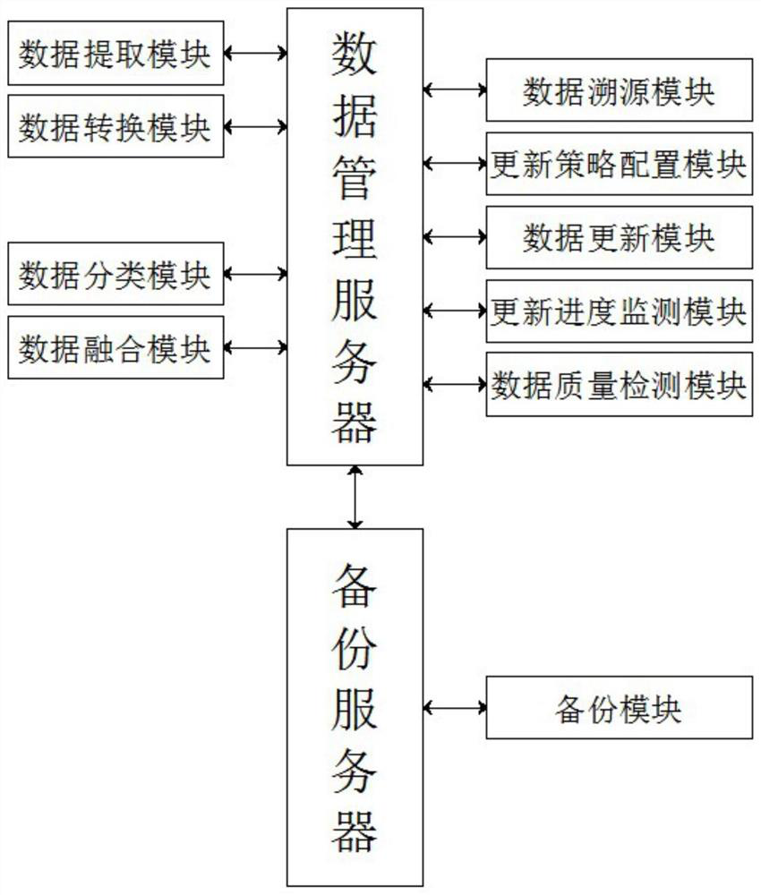
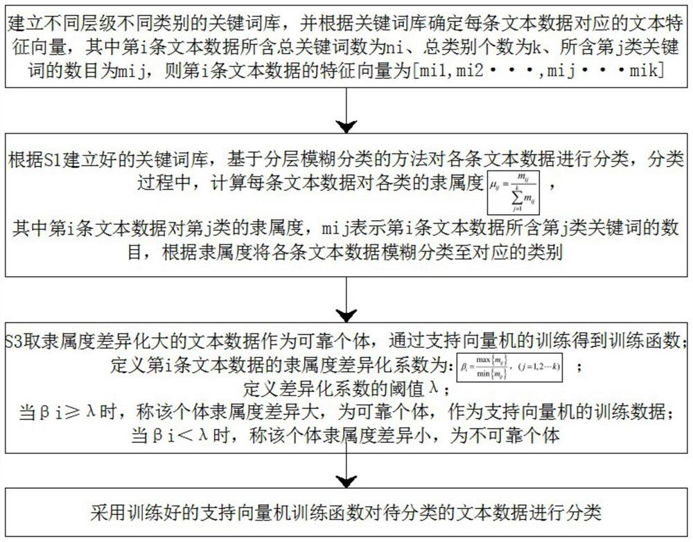
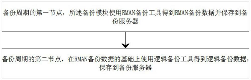
[0046] see Figure 1-3 , the present invention provides a technical solution:

[0047] Fengyun satellite remote sensing surveying and mapping data management system, including:

[0048] A data management server, the data management server is used to ensure the normal operation of each module;

[0049] A data extraction module, the data extraction module communicates with the data management server, and the data extraction module is used to connect with different types of databases and receive data files in different file formats, and extract wind and cloud information from each database Extract Fengyun satellite remote sensing mapping data from satellite remote sensing mapping data and various data files;

[0050] A data conversion module, the data conversion module is connected to the data management server in communication, and the data conversion module is used to convert the Fengyun satellite remote sensing mapping data extracted by the data extraction module into text dat...


PUM


Abstract

The invention discloses a wind cloud satellite remote sensing surveying and mapping data management system, which comprises a data management server, a data extraction module, a data conversion module, a data classification module and a data fusion module, and is characterized in that the data extraction module, the data conversion module, the data classification module and the data fusion module are in communication connection with the data management server. The system is connected with databases of different types, receives data files of different file formats, extracts wind cloud satellite remote sensing surveying and mapping data from the databases and the data files, converts the wind cloud satellite remote sensing surveying and mapping data extracted by the data extraction module into text data, classifies the text data converted by the data conversion module and performs data fusion on the text data classified by the data classification module, thereby realizing collection of multi-source wind cloud satellite remote sensing surveying and mapping data, enhancing the classification accuracy of the wind cloud satellite remote sensing surveying and mapping data and improving the utilization efficiency of later data.

Description

technical field [0001] The invention relates to the technical field of data management, in particular to a Fengyun satellite remote sensing surveying and mapping data management system. Background technique [0002] Fengyun meteorological satellite is a meteorological satellite developed by China in 1977. In 1988, 1990 and 1999, three first-generation polar-orbiting meteorological satellites, namely Fengyun-1 A, B and C meteorological satellites, were launched. In 1997 and 2000, two geostationary orbiting Fengyun-2 meteorological satellites were launched successively, forming the China Meteorological Satellite Operation Monitoring System. After the United States and Russia, the country has two orbiting meteorological satellites at the same time in the world. The crystallization of years of unremitting struggle and independent innovation. [0003] In the existing Fengyun satellite remote sensing surveying and mapping data management system, the data sources are scattered and...

Claims


Application Information

Patent Timeline
Patent Type & Authority Applications(China)
IPC IPC(8): G06F16/35G06F11/14G06K9/62
CPCG06F16/355G06F11/1446G06F18/2411G06F18/25
Inventor 王雅胡友彬史纬恒杨小佳吴永远胡鑫徐君炜宁达俊昊王一怡
Owner 胡友彬
Why Eureka
Try Eureka