
Hyperspectral remote sensing image classification method and device, equipment and storage medium

A technology for hyperspectral remote sensing and image classification, which is applied in the fields of devices, hyperspectral remote sensing image classification methods, equipment and storage media, and can solve problems such as low classification accuracy and inability to effectively express spectral features.

Pending Publication Date: 2021-05-07
WUHAN CENT CHINA GEOLOGICAL SURVEY CENT SOUTH CHINA INNOVATION CENT FOR GEOSCIENCES +1
View PDF4 Cites 6 Cited by
  • Summary
  • Abstract
  • Description
  • Claims
  • Application Information

AI Technical Summary

Problems solved by technology

[0008] The invention proposes a hyperspectral remote sensing image classification method, device, equipment and storage medium, aiming to solve the technical problem that the traditional hyperspectral remote sensing image classification method cannot effectively express all spectral features and the classification accuracy is low

Method used


Image

  • Hyperspectral remote sensing image classification method and device, equipment and storage medium
  • Hyperspectral remote sensing image classification method and device, equipment and storage medium
  • Hyperspectral remote sensing image classification method and device, equipment and storage medium

Examples


Embodiment Construction

[0070] In order to make the purpose, technical solution and advantages of the present invention clearer, the embodiments of the present invention will be further described below in conjunction with the accompanying drawings.

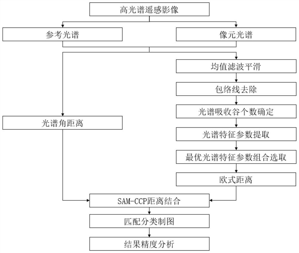
[0071] Please refer to figure 1 , figure 1 It is a flow chart of a hyperspectral remote sensing image classification method based on joint spectral angles and combined feature parameters according to a specific embodiment of the present invention.

[0072] A specific embodiment of the present invention provides a hyperspectral remote sensing image classification method based on joint spectral angles and combined feature parameters, the method comprising the following steps:

[0073] S1. Obtain the reference spectrum of each object type and the pixel spectrum of each pixel from the original hyperspectral remote sensing image, including:

[0074] S11, selecting a hyperspectral remote sensing image classification reference map;

[0075] S12. Obtain a reg...


PUM


Abstract

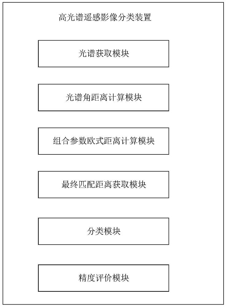
The invention provides a hyperspectral remote sensing image classification method, apparatus and device, and a storage medium. The method comprises the following steps: respectively obtaining a reference spectrum of each ground feature type and a pixel spectrum of each pixel from an original hyperspectral remote sensing image; calculating to obtain a spectral angular distance between the pixel spectrum and the reference spectrum; calculating the Euclidean distance of the optimal spectral characteristic parameter combination between the pixel spectrum and the reference spectrum; combining the spectral angular distance with the Euclidean distance to obtain a final matching distance between the pixel spectrum and the reference spectrum; and according to the final matching distance, judging a ground feature type to which each pixel in the image belongs, outputting a classification result graph of the original hyperspectral remote sensing image based on the ground feature type to which the pixel belongs, and carrying out precision evaluation on the classification result graph. According to the method, the spectral angular distance based on the overall characteristics of the spectrum and the combined characteristic parameter Euclidean distance which highlights the local detail characteristics of the spectrum are combined, so that the classification precision of the hyperspectral remote sensing image is improved.

Description

technical field [0001] The invention relates to the technical field of remote sensing image processing, in particular to a hyperspectral remote sensing image classification method, device, equipment and storage medium. Background technique [0002] Hyperspectral remote sensing is developed on the basis of imaging spectroscopy. It combines the rich spectral features of images with spatial features for the first time. It has the unique advantages of high spectral resolution, continuous spectrum and map-spectrum integration. It has extensive and important applications in the fields of detection, environmental monitoring, geological survey, marine, forestry and agricultural remote sensing. It is an important application of hyperspectral remote sensing technology to identify and classify ground object types based on the rich spectral and spatial information of hyperspectral data. The theoretical basis of its classification is "same object with same spectrum". The features and sp...

Claims


Application Information

Patent Timeline
Patent Type & Authority Applications(China)
IPC IPC(8): G06K9/00G06K9/32G06K9/46G06K9/62
CPCG06V20/194G06V20/13G06V10/25G06V10/44G06F18/241
Inventor 徐宏根吴柯占燕婷刘慧泽
Owner WUHAN CENT CHINA GEOLOGICAL SURVEY CENT SOUTH CHINA INNOVATION CENT FOR GEOSCIENCES
Learn More