Urban agglomeration living space construction time identification method

A technology of living space and recognition method, applied in the direction of character and pattern recognition, instrument, calculation, etc., can solve the problem of lack of "time gap"

Pending Publication Date: 2021-05-18
INST OF GEOGRAPHICAL SCI & NATURAL RESOURCE RES CAS
View PDF3 Cites 2 Cited by
  • Summary
  • Abstract
  • Description
  • Claims
  • Application Information

AI Technical Summary

Problems solved by technology

[0005] The purpose of this invention is to address the current lack of spatial-temporal dynamic research on urban residential land, there are "semantic gaps" and "time gaps" between remote sensing data and social perception data, and the current research lacks research on "time gaps" and other issues , a method for identifying the built-up time of residential space in urban agglomerations is proposed, which identifies the built-up time of urban residential land by fusing the spectral and texture information of remote sensing data and the socioeconomic characteristics of social perception data

Method used


Image

  • Urban agglomeration living space construction time identification method
  • Urban agglomeration living space construction time identification method
  • Urban agglomeration living space construction time identification method

Examples


Embodiment Construction

[0037] The technical solutions of the present invention will be described in further detail below with reference to the accompanying drawings and embodiments.

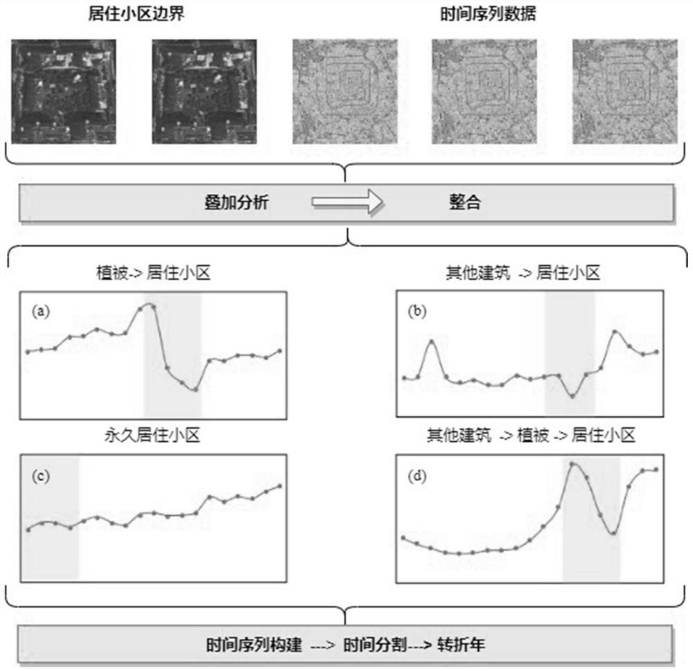
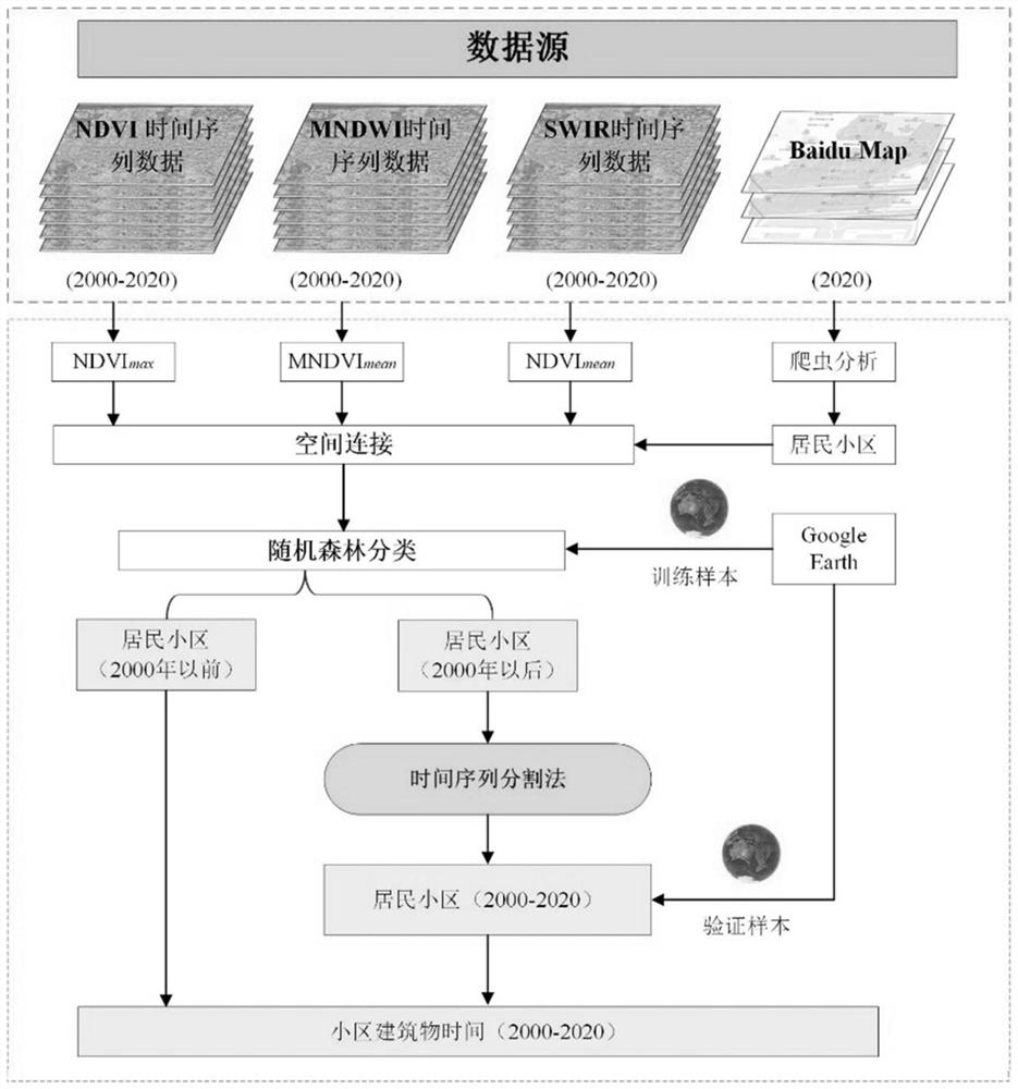
[0038] The invention proposes a method for identifying the construction time of urban agglomeration residential space, which identifies the construction time of urban residential land by fusing the spectrum and texture information of remote sensing data and the socioeconomic characteristics of social perception data. Such as Figure 1 to Figure 6 As shown, a preferred embodiment of the present invention is shown therein.

[0039] In the process of urban development, especially the renewal of community construction, it can be roughly attributed to four types of evolution:

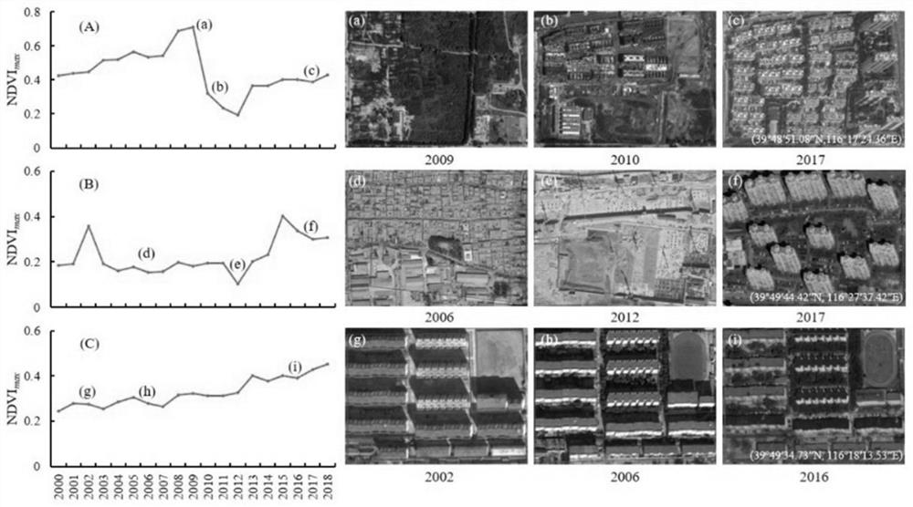
[0040] The first is that the expansion of the city occupies vegetation such as cultivated land / forest. In the process of the land use type of urban renewal changing from vegetation to building, NDVI shows a strong change from high to low and then gr...


PUM


Abstract

The invention relates to an urban agglomeration living space construction time identification method, which comprises the steps of collecting Landsat5/7/8 data through a google earth engine platform, and calculating time sequence data of three indexes, namely, NDVI, MNDWI and SWIR; obtaining urban residential land boundary vector data through map data and crawler analysis, and carrying out data analysis and space connection in Arcgis; classifying and identifying the residential land before and after a specific time point through a random forest classification method; and identifying the construction time of the residential land in a specific time period year through a time sequence segmentation method to complete the identification of the construction time of the whole residential land. According to the method, the construction time of the urban residential land is identified by fusing the spectrum and texture information of the remote sensing data and the social perception data, so that the problems of a semantic gap and a time gap existing in the two data are solved, and scientific and technical means support is provided for researching horizontal and vertical expansion and space-time evolution of the urban residential land.

Description

technical field [0001] The invention relates to the field of identification of the built-up time of residential spaces, in particular to a method for identifying the built-up time of residential spaces in urban agglomerations. Background technique [0002] With the continuous acceleration of the global urbanization process, the United Nations "2018 World Urbanization Prospects" pointed out that by 2050, the total global urban population will increase by 2.5 billion, accounting for 66% of the world's total population, of which China's total urban population will increase 255 million, when China's urbanization rate will be close to 80%. In the rapid development stage of urbanization, with the rapid development of the economy, the rapid growth of population and the rapid expansion of cities will lead to the disorderly growth of urban residential land, and intensify the contradiction between urban construction land and ecological land. Timely monitoring of the spatio-temporal d...

Claims


Application Information

Patent Timeline
Patent Type & Authority Applications(China)
IPC IPC(8): G06K9/00G06K9/62
CPCG06V20/176G06F18/24323G06F18/25
Inventor 方创琳杨智奇张兵张晓玲高春东滕跃陈睿
Owner INST OF GEOGRAPHICAL SCI & NATURAL RESOURCE RES CAS
Why Eureka
Try Eureka