Collaborative planning method of urban and rural infrastructure system based on population flow data

An infrastructure, urban and rural technology, applied in the field of collaborative planning of urban and rural infrastructure systems based on population flow data, can solve problems such as planning can not accurately reflect the needs of the objective world, unreasonable allocation of public resources, insufficient utilization of infrastructure, etc., to achieve rapid and accurate The effect of daily spatiotemporal selective behavior, abundant population flow data, and promotion of coordinated development

Active Publication Date: 2021-11-02
PEKING UNIV
View PDF3 Cites 1 Cited by
  • Summary
  • Abstract
  • Description
  • Claims
  • Application Information

AI Technical Summary

Problems solved by technology

[0003] The past planning methods have long focused on the supply of urban resources, especially the investment in urban infrastructure and spatial layout, and failed to effectively consider urban and rural resources. Moreover, the layout adjustment of infrastructure is often a top-down planning approach. This lacks an effective analysis that combines the status quo of resources, especially the measurement of the actual needs of the current development, resulting in planning that cannot accurately reflect the needs of the objective world
On the one hand, the independent planning model for urban and rural areas does not effectively pay attention to the relationship between urban and rural geographical locations, resulting in unsmooth flow of urban and rural elements and unreasonable allocation of public resources, which is not conducive to the integrated development of urban and rural areas
On the other hand, compared with cities, rural infrastructure construction is insufficient
From a global perspective, oversupply in some areas has resulted in underutilization of infrastructure, serious waste, and a large number of idle facilities; in other areas, infrastructure investment is too low and supply exceeds demand, resulting in increased regional costs and reduced efficiency. Meet the current needs of urban and rural development
[0004] In short, the existing technical methods for urban and rural infrastructure planning cannot make an overall layout of urban and rural elements, and fail to identify the primary and secondary and core areas of planning based on the actual situation, and cannot accurately reflect the impact of rapid population flow on infrastructure space. The needs of the layout, let alone the planning goal of effectively combining public interests, there are a lot of infrastructure shortages and waste problems, and it is difficult to achieve optimal allocation

Method used


Image

  • Collaborative planning method of urban and rural infrastructure system based on population flow data
  • Collaborative planning method of urban and rural infrastructure system based on population flow data
  • Collaborative planning method of urban and rural infrastructure system based on population flow data

Examples


Embodiment Construction

[0056] The present invention will be further described through specific embodiments below in conjunction with the accompanying drawings. It should be understood that these embodiments are only used to illustrate the present invention and are not intended to limit the scope of the present invention. After reading the present invention, those skilled in the art all fall within the appended claims of the present invention to the amendments of various equivalent forms of the present invention. limited range.

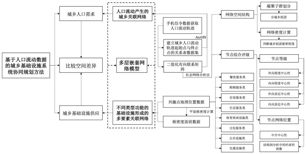
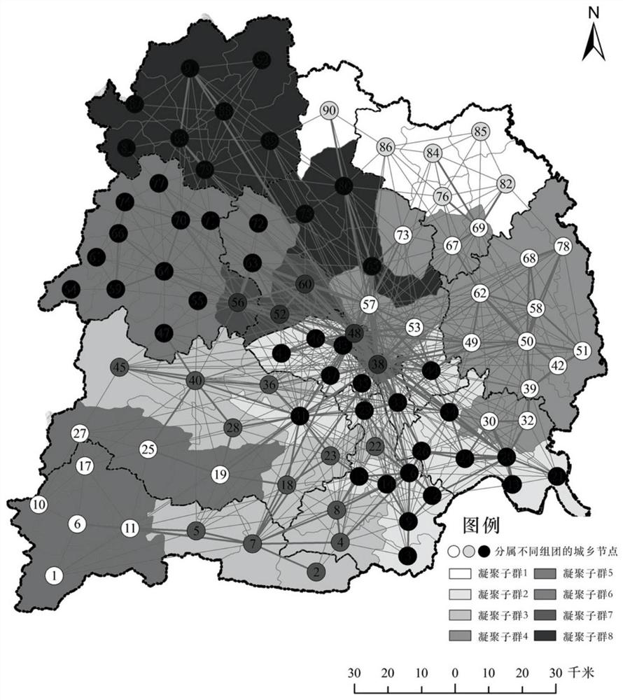
[0057] The urban-rural infrastructure system collaborative planning method based on population flow data of the present invention is realized by constructing a multi-layer nested network model including an urban-rural association network and a multi-element association network. First, through the social network analysis method, the urban-rural relational network is divided into cohesive subgroups to obtain closely connected groups. On this basis, determine the node level an...


PUM


Abstract

The invention discloses a collaborative planning method for urban and rural infrastructure systems based on population flow data, which determines the group division, node level and network location of different urban and rural nodes through the urban-rural association network established by the population flow data, and according to different types of functions in the current situation Comparing the multi-factor association network formed by the existing infrastructure, the supply and demand difference between the urban-rural association network that affects the target decision-making and the existing multi-factor association network is found, so as to adjust the spatial layout and configuration of infrastructure in the multi-element association network, so as to Match the node levels and positions in the urban-rural correlation network, thereby realizing the effective planning and reasonable adjustment of urban and rural infrastructure facilities, the efficient and precise allocation of resources for infrastructure integration and the optimization of the global pattern, in order to promote the integration of urban and rural infrastructure and The coordinated development of the system provides a new means of planning.

Description

technical field [0001] The invention relates to the technical fields of urban planning, land utilization, and industrial layout, in particular to a collaborative planning method for urban and rural infrastructure systems based on population flow data. Background technique [0002] Due to differences in land use, policy systems, production functions, living culture, and social relations between cities and villages in my country, the dual structure of urban and rural areas has long led to unbalanced urban-rural development and diminished spatial connections, resulting in regional divisions and resource constraints. Segmentation and urban-rural division, problems such as spatial fragmentation, connection isolation, and population outflow have emerged between urban and rural areas. It also further exacerbates the real dilemma of poor rural foundation, low investment and slow development. With the rapid development of my country's transportation and the advancement of urbanizatio...

Claims


Application Information

Patent Timeline
Patent Type & Authority Patents(China)
IPC IPC(8): G06Q10/06G06Q50/26
CPCG06Q10/06315G06Q10/0637G06Q10/06393G06Q50/26
Inventor 刘钊汪芳薛鹏程
Owner PEKING UNIV
Why Eureka
Try Eureka