
Autonomous orbit determination method and system for low-orbit satellite constellation

A low-orbit satellite and autonomous orbit determination technology, applied in the field of satellite orbit determination, can solve the problems of inaccurate orbit determination of low-orbit satellite constellations and a small number of ground monitoring stations, achieve enhanced geometric configuration, improve orbit determination accuracy, and solve the The effect of high cost of building a website

Pending Publication Date: 2021-06-22
重庆两江卫星移动通信有限公司
View PDF0 Cites 4 Cited by
  • Summary
  • Abstract
  • Description
  • Claims
  • Application Information

AI Technical Summary

Problems solved by technology

[0003] The problem to be solved by the present invention is that the number of ground monitoring stations in the prior art is small, and the geographical location of the ground monitoring stations is unevenly distributed, resulting in inaccurate orbit determination of the low-orbit satellite constellation. The present invention provides an autonomous orbit determination of the low-orbit satellite constellation The method and system directly use inter-satellite link data and GNSS receiver observation data to realize high-precision and safe autonomous orbit determination of low-orbit satellites without going through ground monitoring stations

Method used


Image

  • Autonomous orbit determination method and system for low-orbit satellite constellation

Examples


Embodiment 1

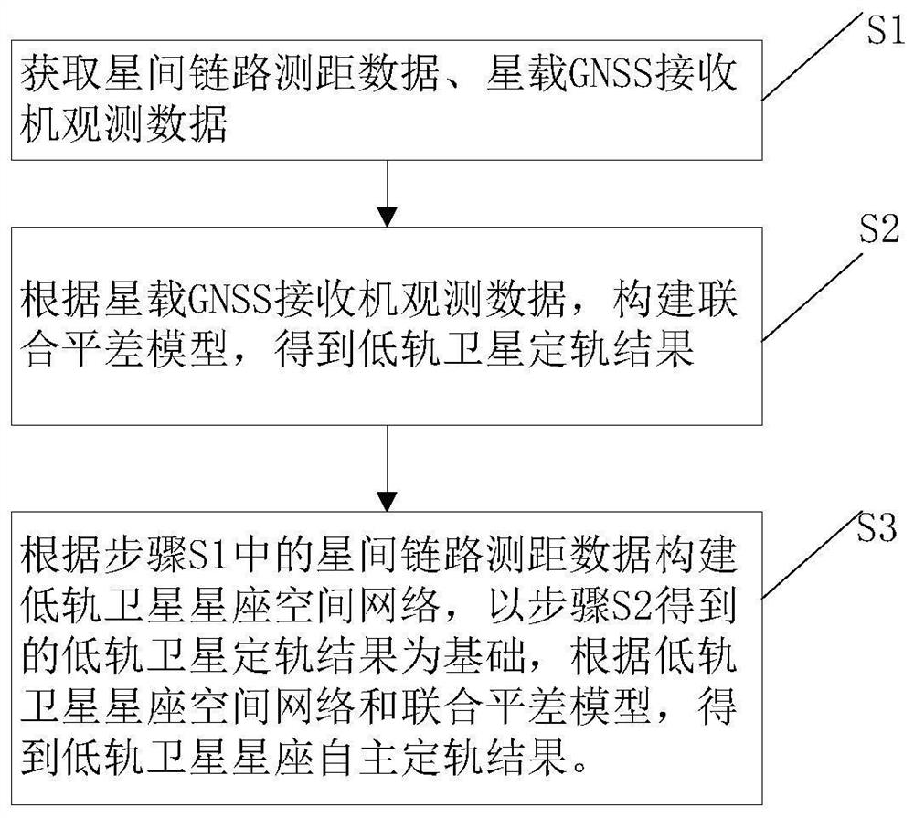
[0046] Such as figure 1 As shown, a method for autonomous orbit determination of a low-orbit satellite constellation is proposed in Embodiment 1, including the following steps:

[0047] Step S1, obtaining inter-satellite link ranging data and satellite-borne GNSS receiver observation data;

[0048] Step S2, according to the observation data of the spaceborne GNSS receiver, construct the joint adjustment model, and obtain the orbit determination result of the low-orbit satellite,

[0049] Step S3, constructing the LEO satellite constellation space network according to the inter-satellite link ranging data in step S1, based on the LEO satellite orbit determination results obtained in step S2, according to the LEO satellite constellation space network and the joint adjustment model, Obtain the autonomous orbit determination results of the low-orbit satellite constellation.

[0050] Further, the specific process of step S2 is:

[0051] Step S21, preprocessing the observation da...

Embodiment 2

[0073] This embodiment 2 provides a low-orbit satellite constellation autonomous orbit determination system, which is used to implement the method in embodiment 1, including a data acquisition module, a model building module, a data processing module, and an autonomous orbit determination module, wherein,

[0074] The data acquisition module is used to acquire inter-satellite link ranging data, spaceborne GNSS receiver observation data, navigation signals and spaceborne GNSS receiver cut-off elevation angle;

[0075] The model building module builds the model based on the data obtained by the data acquisition module, including building an observation model based on the observation data of the spaceborne GNSS receiver, constructing a low-orbit satellite constellation space network based on the inter-satellite link ranging data, and building a space network based on navigation signals and The stochastic model constructed by the cut-off altitude angle of the spaceborne GNSS receiv...


PUM


Abstract

The invention discloses an autonomous orbit determination method and system for a low-orbit satellite constellation. The method comprises the following steps: acquiring inter-satellite link ranging data and satellite-borne GNSS receiver observation data; establishing an observation model by using the observation data, and preprocessing the observation data; carrying out on-satellite PPP calculation by utilizing the preprocessed observation data to obtain an on-orbit rough spatial position of each low-orbit satellite; selecting an orbit determination perturbation correction mechanical model to establish a low-orbit satellite dynamic differential equation; establishing an orbit determination function model by combining the observation model; constructing a random model, fusing the orbit determination function model and the random model to establish a joint adjustment model, and obtaining a low-orbit satellite orbit determination result; constructing a low-orbit satellite constellation space network by using inter-satellite link ranging data, obtaining an autonomous orbit determination result of the low-orbit satellite constellation by combining a joint adjustment model, and realizing on-satellite high-precision safe autonomous orbit determination of the low-orbit satellite by directly using the inter-satellite link ranging data and observation data of a GNSS receiver.

Description

technical field [0001] The invention relates to the technical field of satellite orbit determination, in particular to a method and system for autonomous orbit determination of low-orbit satellite constellations. Background technique [0002] With the gradual development and in-depth use of low-orbit satellites in different fields, low-orbit satellites gradually appear in the form of constellations, and in some fields, the demand for orbit determination accuracy of low-orbit satellite orbits is getting higher and higher. At present, the high Precision orbit determination products are produced by various data analysis centers by analyzing the GNSS observations of a large number of ground monitoring stations. However, due to international political factors, geographical factors, and data safety and reliability requirements, it is currently impossible to build a large number of foreign stations. Increased the difficulty of continuous, safe and controllable monitoring of low-orb...

Claims


Application Information

Patent Timeline
Patent Type & Authority Applications(China)
IPC IPC(8): G01C21/24
CPCG01C21/24
Inventor 杨鑫谭理庆唐帅刘俊杨晋
Owner 重庆两江卫星移动通信有限公司
Learn More