Weather radar base data three-dimensional curved surface triangulation network construction method

A technology of weather radar and surface triangulation, applied in the field of detection data, can solve problems such as unsatisfactory 3D visualization effect and insufficient vertical accuracy

Pending Publication Date: 2021-06-25
河南省气象台
View PDF2 Cites 1 Cited by
  • Summary
  • Abstract
  • Description
  • Claims
  • Application Information

AI Technical Summary

Problems solved by technology

[0003] The above-mentioned use of multi-layer cone scanning data of the radar to construct a triangular surface, and the trapezoidal cylinder is used to divide the entire radar data space, which has insufficient vertical precision, resulting in unsatisfactory 3D visualization

Method used


Image

  • Weather radar base data three-dimensional curved surface triangulation network construction method
  • Weather radar base data three-dimensional curved surface triangulation network construction method
  • Weather radar base data three-dimensional curved surface triangulation network construction method

Examples


Embodiment Construction

[0041] The embodiments of the present invention will be described in detail below in conjunction with the accompanying drawings. This embodiment is implemented on the premise of the technical solution of the present invention, and detailed implementation methods and specific operating procedures are provided, but the scope of protection of the present invention is not limited to the following Described embodiment.

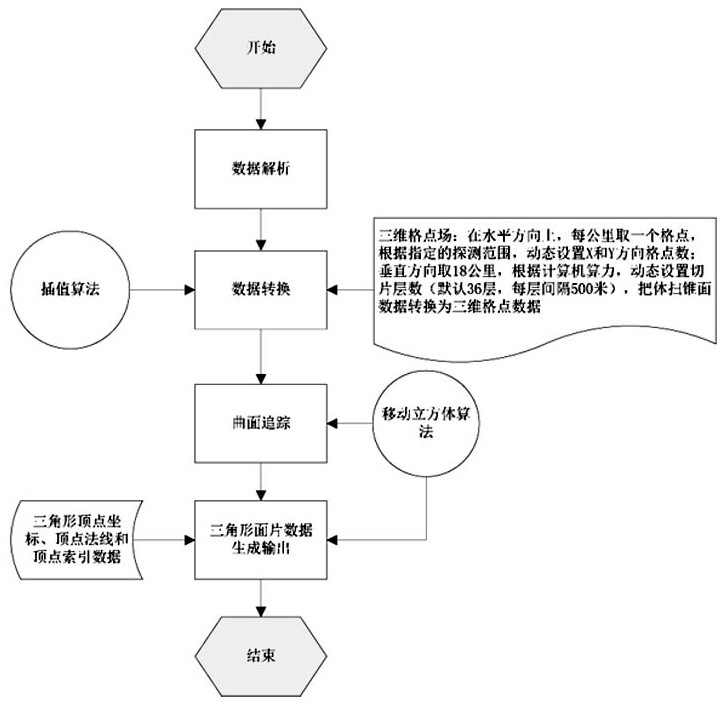
[0042] Such as figure 1 Shown, the three-dimensional curved surface triangular network construction method of weather radar basic data of the present invention, comprises the following steps:

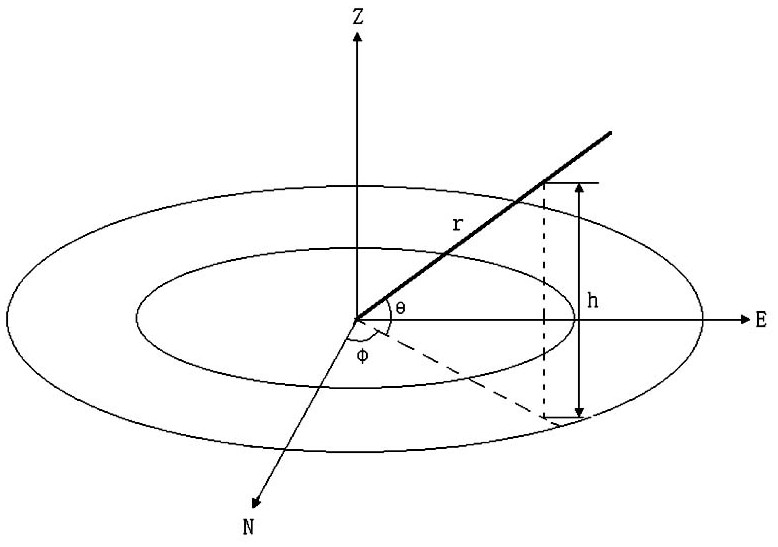
[0043] S1, data analysis: analyze the basic data according to the storage characteristics and encoding format of the weather radar basic data, and obtain the three-dimensional cone data expressed in polar coordinates; figure 2 as shown, figure 2 Among them, N is the true north direction, E is the true east direction, and Z is the vertical direction; r is the distance fro...


PUM


Abstract

The invention discloses a weather radar base data three-dimensional curved surface triangulation network construction method, which comprises the following steps of: S1, data analysis, namely analyzing base data according to weather radar base data storage characteristics and a coding format to obtain three-dimensional conical surface data expressed by polar coordinates; S2, data conversion, namely converting the three-dimensional conical surface data represented by polar coordinates into three-dimensional grid point field data represented by Cartesian coordinates through a data interpolation method according to the coordinate range of the specified region; S3, curved surface tracking, namely using a moving cube algorithm to track an equivalent curved surface representing a certain element value, wherein the equivalent curved surface is formed by connecting a plurality of triangles according to a certain topological structure; and S4, data output, namely outputting and storing the triangulation network information representing the equivalent surface. According to the weather radar base data three-dimensional curved surface triangulation network construction method, the constructed three-dimensional grid point field data improves the vertical direction data density, a three-dimensional grid point field can be dynamically constructed according to a specified radar detection range, and three-dimensional reconstruction of a storm monomer or a local range becomes reality.

Description

technical field [0001] The invention relates to detection data in weather forecasting, in particular to a method for constructing a three-dimensional surface triangulation network based on weather radar basic data. Background technique [0002] The new-generation Doppler weather radar detection data is one of the most commonly used detection data in weather forecasting. It is of great significance for studying the formation of precipitation, analyzing small and medium-scale weather systems, and warning of strong convective weather. It is an important tool for small and medium-scale weather monitoring. , providing great help for meteorologists to make accurate forecasts. Existing analysis methods for weather radar echoes mainly stay on two-dimensional planes, such as PPI (Plane Position Display), CAPPI (Contour Plane Position Display) and RHI (Range Height Display) and other plane images, which cannot express storm well. Three-dimensional structural characteristics of cloud ...

Claims


Application Information

Patent Timeline
IPC IPC(8): G01S7/41G01S13/95G06T17/20
CPCG01S7/41G01S13/95G06T17/20Y02A90/10
Inventor 张霞申琳申永辰于童吕林宜栗晗
Owner 河南省气象台
Why Eureka
Try Eureka