Geographic information cloud storage system based on extension structure

A technology of cloud storage system and geographic information, which is applied in the field of geographic information cloud storage system based on topological structure, can solve problems such as low efficiency, inability to reduce data volume, and lack of correlation of stored data, so as to reduce the amount of stored data and reduce the Difficulty of storage, effect of deepening association

Inactive Publication Date: 2021-06-25
深圳市智尊保汽车科技有限公司
View PDF8 Cites 0 Cited by
  • Summary
  • Abstract
  • Description
  • Claims
  • Application Information

AI Technical Summary

Problems solved by technology

However, the storage system cannot reduce the amount of stored data, and there is a lack of correlation between the stored data, and the efficiency of model data reconstruction is low

Method used


Image

  • Geographic information cloud storage system based on extension structure
  • Geographic information cloud storage system based on extension structure
  • Geographic information cloud storage system based on extension structure

Examples


Embodiment 1

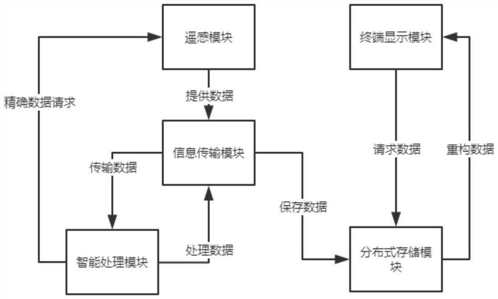
[0027] A geographical information cloud storage system based on topology, including a distributed storage module, a remote sensing module, an information transmission module, an intelligent processing module and a terminal display module, the remote sensing module is used to capture high-definition images and provide high-precision measurement data, The information transmission module sends the image and the measurement data to the intelligent processing module, and the intelligent processing module analyzes the image and combines the measurement data for topological structure to form a plurality of interrelated A data packet, the data packet is stored in each storage point of the distributed storage module, and the terminal display module requests the data packet from the distributed storage module and reconstructs it into a visual model for display;

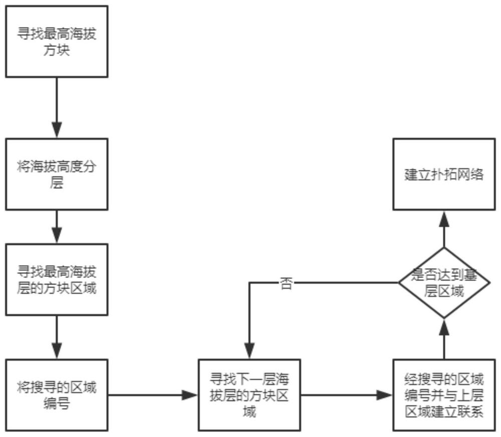
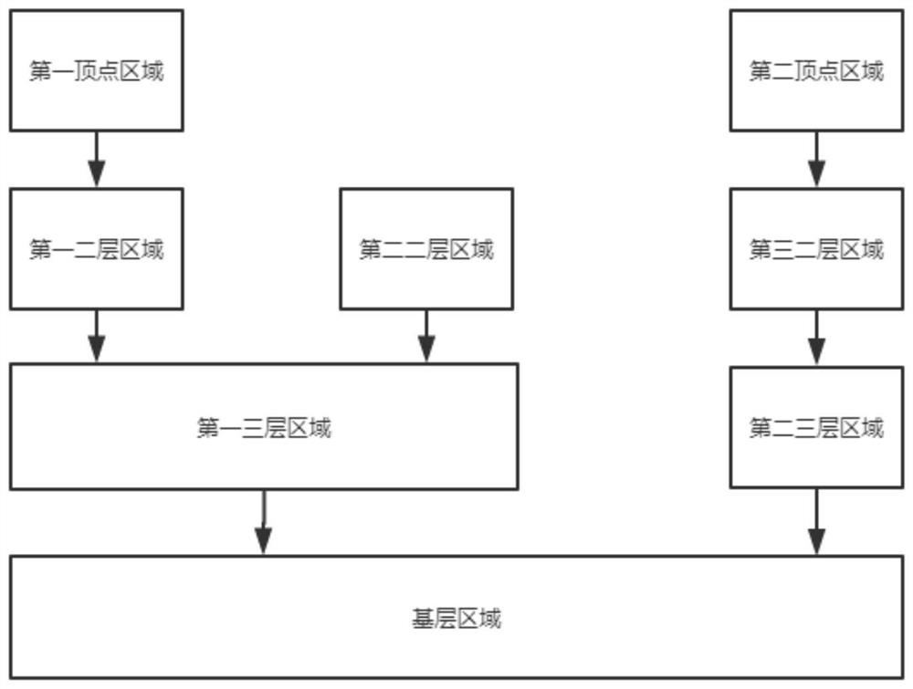
[0028] The intelligent processing module divides geographic areas into basic geographic areas and human geographic areas, and ...

Embodiment 2

[0037] A geographical information cloud storage system based on topology, including a distributed storage module, a remote sensing module, an information transmission module, an intelligent processing module and a terminal display module, the remote sensing module is used to capture high-definition images and provide high-precision measurement data, The information transmission module sends the image and the measurement data to the intelligent processing module, and the intelligent processing module analyzes the image and combines the measurement data for topological structure to form a plurality of interrelated A data packet, the data packet is stored in each storage point of the distributed storage module, and the terminal display module requests the data packet from the distributed storage module and reconstructs it into a visual model for display;

[0038] The intelligent processing module divides geographic areas into basic geographic areas and human geographic areas, and ...

Embodiment 3

[0057] A geographical information cloud storage system based on topology, including a distributed storage module, a remote sensing module, an information transmission module, an intelligent processing module and a terminal display module, the remote sensing module is used to capture high-definition images and provide high-precision measurement data, The information transmission module sends the image and the measurement data to the intelligent processing module, and the intelligent processing module analyzes the image and combines the measurement data for topological structure to form a plurality of interrelated A data packet, the data packet is stored in each storage point of the distributed storage module, and the terminal display module requests the data packet from the distributed storage module and reconstructs it into a visual model for display;

[0058] The intelligent processing module divides geographic areas into basic geographic areas and human geographic areas, and ...


PUM


Abstract

The invention provides a geographic information cloud storage system based on an extension structure, which comprises a distributed storage module, a remote sensing module, an information transmission module, an intelligent processing module and a terminal display module. The remote sensing module is used for shooting high-definition images and providing high-precision measurement data. The information transmission module sends the image and the measurement data to the intelligent processing module, the intelligent processing module analyzes the image and then performs extension structuring in combination with the measurement data to form a plurality of data packets associated with each other, and the data packets are stored in each storage point of the distributed storage module. And the terminal display module requests the data packet from the distributed storage module and reconstructs the data packet into a visual model for display. By expanding the structured geographic information, the relation between the block data packets is greatly enhanced, the storage space is reduced, and the efficiency of model data reconstruction is improved.

Description

technical field [0001] The invention relates to the technical field of geographic information, in particular to a geographic information cloud storage system based on a topological structure. Background technique [0002] Geographical information is the geographical meaning contained and expressed by geographic data. It is a general term for numbers, texts, images and graphics related to the quantity, quality, nature, distribution characteristics, connections and laws of substances related to geographical environment elements. Geographical information has data The quality of its storage method directly affects the efficiency of the use of geographic information. [0003] Many geographic information storage systems have been developed now. After a lot of searching and reference, we found that the existing geographic information storage systems are like the systems disclosed in the publication numbers KR101633836B1, KR1020110081863A and KR1020140073852A. The methods include: d...

Claims


Application Information

Patent Timeline
Patent Type & Authority Applications(China)
IPC IPC(8): G06F16/29G06F16/26G06F16/51G06F16/535G06F16/54G06F16/583
CPCG06F16/26G06F16/29G06F16/51G06F16/535G06F16/54G06F16/583
Inventor 王颖夏敏纳余谦程泊静何苏博邹瑞睿杨明鄂漆江艳
Owner 深圳市智尊保汽车科技有限公司
Why Eureka
Try Eureka