
A camera-based automated precision road map generation system and method

A map generation and camera technology, applied to road network navigators, maps/plans/charts, image enhancements, etc., can solve problems such as hazards to safety, multi-manpower and cost, consumption, etc., to achieve accurate generation, reduce implementation costs, reduce The effect of generating costs

Pending Publication Date: 2021-06-25
KOREA EXPRESSWAY CORPORATION +1
View PDF1 Cites 1 Cited by
  • Summary
  • Abstract
  • Description
  • Claims
  • Application Information

AI Technical Summary

Problems solved by technology

It will consume a lot of manpower and cost when using this MMS device to build and update the precise route map
In particular, when the state of the road changes, the precise route map cannot be updated quickly, so it becomes a safety hazard for vehicles that rely on the precise route map for automatic driving

Method used


Image

  • A camera-based automated precision road map generation system and method
  • A camera-based automated precision road map generation system and method
  • A camera-based automated precision road map generation system and method

Examples


Embodiment Construction

[0040] The terminology in this invention will be organized first.

[0041] Road facility objects refer to the facilities included in the precision map, including road signs, warning signs, control signs, guide signs, auxiliary signs, sign boards, signal lights, street lights, pillars, inspection wells, curbs, medians, fire hydrants and at least one of buildings and the like. Such road facility objects may be fixed or displayed on the road surface, and may also be facilities suspended in the air such as signal lights, some feature points of buildings or signboards or displayed on the facilities.

[0042] That is, the road facility object means all types of facilities that can be included in the precise map, and includes various road signs, warning signs, regulatory signs, guide signs, auxiliary signs, sign boards, signal lights, street lamps, pillars, inspection wells, etc. Concepts such as curbs, medians, fire hydrants, and building signboards, at least one of these objects c...


PUM


Abstract

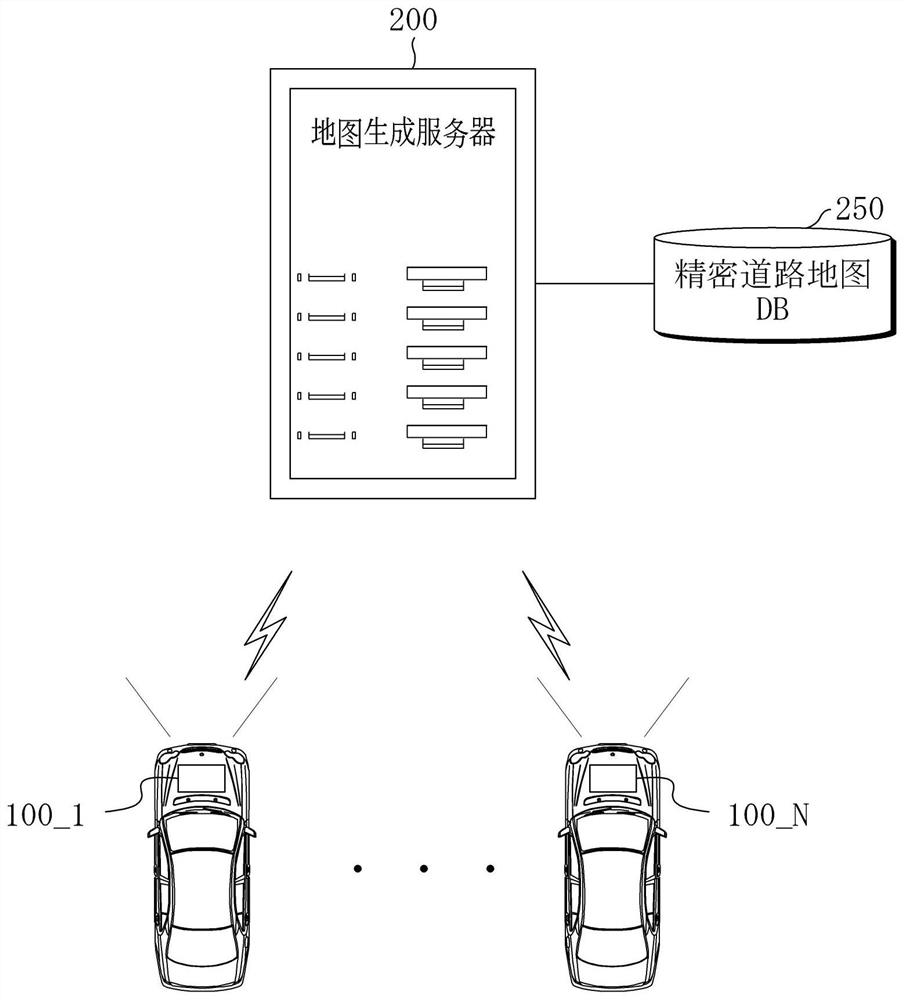
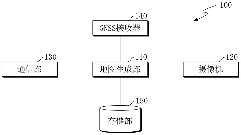
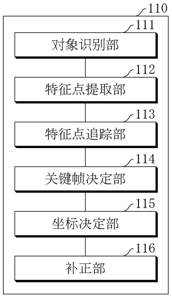
A camera-based automated precision road map generation system according to one embodiment is disclosed in the present document. An object recognition unit recognizes a road facility object including at least one of a GCP object and a general object and an attribute in units of frames of the road image; a feature point extraction unit extracts feature points of at least one or more road facility objects from the road image; a feature point tracking unit matches and tracks the feature points in successive frames of the road image; a coordinate determination unit acquires the relative space coordinates of the feature points so as to minimize the difference between the camera attitude information predicted from the tracked feature points and the calculated camera attitude information; when the GCP object is recognized, the correction unit corrects the target space coordinates of the feature point on the basis of the coordinate point of the GCP object, the absolute space coordinates of which are known, so as to acquire the absolute space coordinates of the feature point.

Description

technical field [0001] Various embodiments disclosed in this document relate to techniques for automatically generating and updating sophisticated road maps based on cameras for autonomous driving. Background technique [0002] For safe autonomous driving, an autonomous vehicle can recognize the surrounding environment of the vehicle and the position of the vehicle, and based on the recognized information, generate a route that enables the vehicle to travel safely and efficiently. Additionally, the autonomous vehicle can control the steering and speed of the vehicle according to the generated path. [0003] Self-driving vehicles can use onboard sensors (for example, cameras, laser scanners, radars, GNSS (Global Navigation Satellite System), IMU (Inertial Measurement Unit), etc.) to monitor the surrounding environment of the vehicle (for example, road facilities such as lanes and signal lights) or landmarks) and generate a path based on the recognized surrounding environment...

Claims


Application Information

Patent Timeline
Patent Type & Authority Applications(China)
IPC IPC(8): G06T7/246G06T7/80G06T17/05G06K9/00G06K9/46G01C21/32
CPCG06T7/246G06T7/80G06T17/05G01C21/32G06T2207/30252G06T2207/30244G06V20/56G06V10/40G01C21/30G06F16/29G09B29/003G01C11/28G01C11/36G01C21/367G06V20/58G06F18/213
Inventor 崔寅球朴宰亨金己昶金德重
Owner KOREA EXPRESSWAY CORPORATION
Learn More