Method and device for measuring precision of satellite positioning system

A technology of satellite positioning system and measuring device, which is applied in the direction of satellite radio beacon positioning system, measuring device, radio wave measuring system, etc., can solve the problems of time-consuming, laborious, large error, etc., and achieve difficult adjustment, simple structure, and realization of displacement The effect of precision

Pending Publication Date: 2021-06-29
CHINESE ACAD OF AGRI MECHANIZATION SCI
View PDF15 Cites 0 Cited by
  • Summary
  • Abstract
  • Description
  • Claims
  • Application Information

AI Technical Summary

Problems solved by technology

However, there is currently no user-oriented testing device or mechanism, which requires rough manual measurement, which not only has large errors, but also takes time and effort.

Method used


Image

  • Method and device for measuring precision of satellite positioning system
  • Method and device for measuring precision of satellite positioning system
  • Method and device for measuring precision of satellite positioning system

Examples


Embodiment Construction

[0064] Below in conjunction with accompanying drawing, structural principle and working principle of the present invention are specifically described:

[0065] Now navigation technology has spread in all aspects of life, but when users purchase Beidou or GPS positioning systems, they need to consider many indicators, which requires a method and device for quickly detecting Beidou or GPS navigation accuracy. The functional requirements of most users for Beidou or GPS can generally be divided into: latitude and longitude accuracy (positioning accuracy), elevation accuracy, heading angle accuracy and speed accuracy.

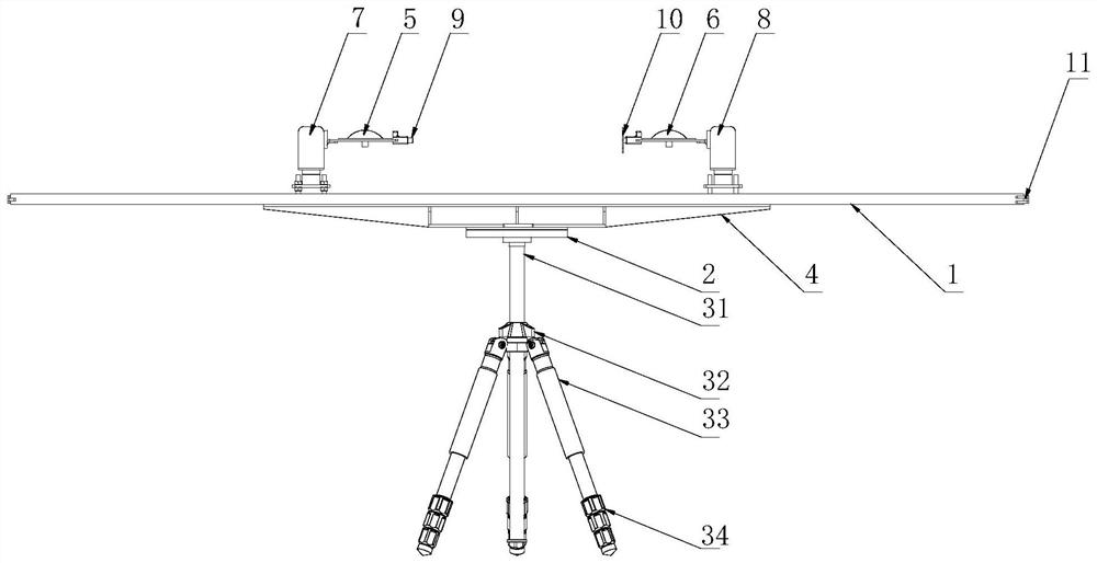
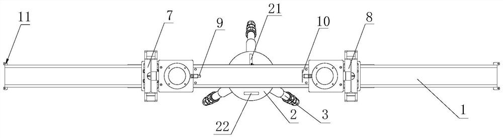
[0066] see figure 1 and figure 2 , figure 1 It is a schematic structural diagram of a measuring device according to an embodiment of the present invention, figure 2 for figure 1 top view. The measuring device of the accuracy of the satellite positioning system of the present invention comprises: a tripod 3, including a leg 33 and a lift rod 31, the lift rod 3...


PUM


Abstract

The invention discloses a method and a device for measuring precision of a satellite positioning system. The device comprises a tripod which comprises supporting legs and a lifting rod, wherein the lifting rod is installed on the supporting legs, the supporting legs are provided with supporting leg adjusting nuts, and the height of the lifting rod is adjusted through using the lifting nuts; a sliding rail mounted on the lifting rod through a rotating platform; and a first antenna installation platform which is installed on the sliding rail, the first antenna installation platform comprises a base, an automatic leveling mechanism and an antenna tray, the automatic leveling mechanism is installed on the base, the antenna tray is installed on the automatic leveling mechanism, and a laser transmitter / target installation base is further arranged on the antenna tray. The invention further provides the method for measuring the precision of the satellite positioning system. The device is simple in structure, easy to carry, convenient to operate and high in environmental energy adaptability, and can measure the displacement precision, the speed precision, the course angle precision and the elevation precision of a single-antenna or double-antenna satellite positioning system.

Description

technical field [0001] The invention relates to satellite positioning automatic navigation control technology, in particular to a measurement method and device for quickly measuring the accuracy of a satellite positioning system. Background technique [0002] Satellite positioning technology has developed rapidly and has now been applied to every aspect of our lives. Satellite positioning system can provide position, heading angle, elevation and other information, and it is widely used in automobile, agriculture and other industries. At present, many companies have their own satellite positioning systems and their algorithms. But there is a big gap in its accuracy and performance. In particular, when some research institutions purchase Beidou navigation systems, they need to choose a suitable navigation system according to their own projects or applications. selection. However, there is no user-oriented testing device or mechanism at present, and manual rough measurement...

Claims


Application Information

Patent Timeline
Patent Type & Authority Applications(China)
IPC IPC(8): G01S19/23
CPCG01S19/23
Inventor 赵士猛郭大方伟利国赵博苑严伟胡小安
Owner CHINESE ACAD OF AGRI MECHANIZATION SCI
Why Eureka
Try Eureka