Map data processing method and device, equipment and storage medium

A technology of map data and processing methods, applied in the field of data processing, can solve problems such as lack of elevation data z, lack of accurate road data, and inability to integrate DTM model data to achieve the effect of improving accuracy

Pending Publication Date: 2021-07-02
SHENYANG MXNAVI CO LTD
View PDF10 Cites 2 Cited by
  • Summary
  • Abstract
  • Description
  • Claims
  • Application Information

AI Technical Summary

Problems solved by technology

[0003] The digital terrain model (Digital Terrain Model, DTM model) models the earth's surface and stores height information, but lacks accurate road data, so it is necessary to introduce road data into the DTM model through the integration of 2D electronic maps and DTM models
[0004] Due to the different data collection methods, the track points in the 2D electronic map only have x and y coordinate data, but no elevation data z, and cannot be directly integrated with DTM model data

Method used


Image

  • Map data processing method and device, equipment and storage medium
  • Map data processing method and device, equipment and storage medium
  • Map data processing method and device, equipment and storage medium

Examples


Embodiment 1

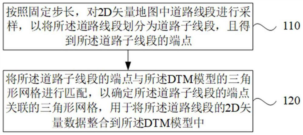
[0027] figure 1 It is a flow chart of a map data processing method provided by Embodiment 1 of the present invention. This embodiment is applicable to the situation of integrating 2D vector data of road segments into a DTM model. implemented by a data processing device, which may be implemented by software and / or hardware. see figure 1 , the map data processing method provided in this embodiment, including:

[0028] Step 110: Sampling the road segment in the 2D vector map according to a fixed step size, so as to divide the road segment into road sub-segments, and obtain the endpoints of the road sub-segments.

[0029] According to the fixed step, the road segment in the 2D vector map is sampled, that is, the road segment is segmented according to the fixed step, and the horizontal and vertical coordinates of the road sub-segment (or road segment) and the two endpoints of the road sub-segment are obtained.

[0030] In this embodiment, optionally, the fixed step size is less ...

Embodiment 2

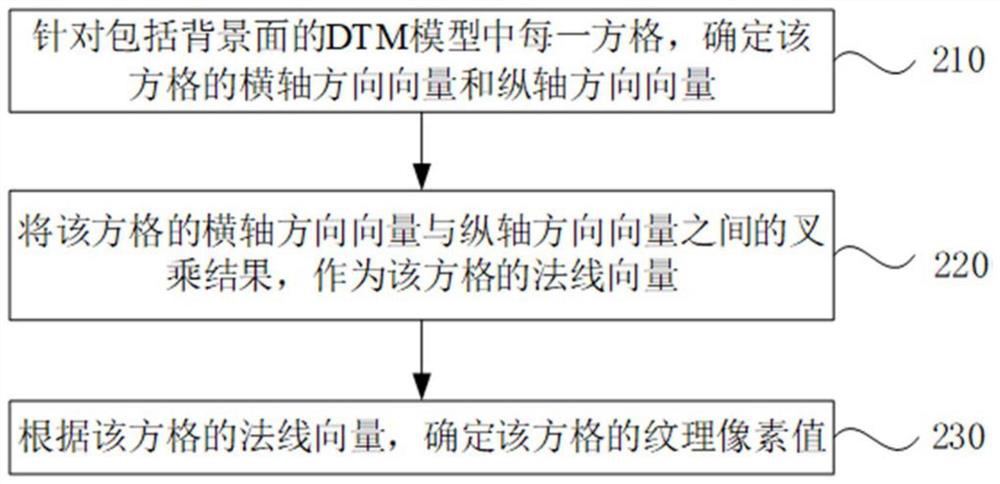
[0061] figure 2 It is a flow chart of a method for processing map data provided by Embodiment 2 of the present invention. This technical solution is a supplementary description of the process after constructing the DTM model including the background surface. The solutions in the embodiments of the present invention may be combined with any of the foregoing embodiments. Compared with the above scheme, the specific optimization of this scheme is, for each square in the DTM model including the background surface, determine the horizontal axis direction vector and the vertical axis direction vector of the square;

[0062] The result of the cross product between the horizontal axis direction vector and the vertical axis direction vector of the grid is used as the normal vector of the grid;

[0063] Determine the texel value of the grid according to the normal vector of the grid.

[0064] Specifically, the flow chart of the map data processing method is as follows figure 2 Sho...

Embodiment 3

[0082] Figure 4 It is a flowchart of a method for processing map data provided by Embodiment 3 of the present invention. This technical solution is a supplementary description of the process after the 2D vector data of the road segment is integrated into the DTM model. The solutions in the embodiments of the present invention may be combined with any of the foregoing embodiments. Compared with the above scheme, this scheme is specifically optimized as, for each endpoint in the road line segment, if the endpoint is a vertex between two adjacent road line segments, then according to the two adjacent road line segments being the The endpoints identify two auxiliary points;

[0083] Otherwise, determine four auxiliary points for the endpoint according to the road segment to which the endpoint belongs;

[0084] Draw the road surface according to the endpoints in the road segment and the determined auxiliary points.

[0085] Specifically, the flow chart of the map data processi...


PUM


Abstract

The embodiment of the invention discloses a map data processing method and device, equipment and a storage medium. The method comprises the following steps: sampling road segments in a 2D vector map according to a fixed step length so as to divide the road segments into road sub-segments and obtain end points of the road sub-segments; matching the endpoints of the road sub-segments with the triangular mesh of a DTM model to determine the triangular mesh associated with the endpoints of the road sub-segments for integrating the 2D vector data of the road segments into the DTM model. By running the technical scheme provided by the embodiment of the invention, the problem that the height of the road segments in the 2D electronic map needs to be determined in the process of integrating the 2D electronic map data and the DTM model data can be solved. Accuracy of the height corresponding to the road segments is improved, and the road segments can change along the terrain in the DTM model.

Description

technical field [0001] Embodiments of the present invention relate to data processing technologies, and in particular to a map data processing method, device, equipment, and storage medium. Background technique [0002] The core data in the current geographic information system, such as point, line (road, river, etc.), surface (green space, water system, etc.) data on the electronic map, is mainly 2D data. [0003] The Digital Terrain Model (DTM model) models the earth's surface and stores height information, but lacks accurate road data. Therefore, it is necessary to introduce road data into the DTM model through the integration of 2D electronic maps and DTM models. [0004] Due to the different data collection methods, the track points in the 2D electronic map only have x and y coordinate data, but no elevation data z, and cannot be directly integrated with DTM model data. Therefore, in the process of integrating 2D electronic map data and DTM model data, it is necessary ...

Claims


Application Information

Patent Timeline
Patent Type & Authority Applications(China)
IPC IPC(8): G06T11/20G06T11/00G06F16/29G06T17/05
CPCG06T11/203G06F16/29G06T17/05G06T11/001
Inventor 任海滨赵鲁
Owner SHENYANG MXNAVI CO LTD
Why Eureka
Try Eureka