An automatic reasoning method for the flow direction of waterway bridge tributaries based on conversion nodes

An automatic reasoning and waterway bridge technology, applied in the field of map synthesis, can solve problems such as the influence of accuracy, the difficulty of accurately describing the flow direction of rivers, and the difficulty in ensuring the accuracy of flow direction reasoning, so as to achieve the effect of accurate direction, good precision, and guarantee of subsequent transportation

Active Publication Date: 2021-11-09
CHINESE ACAD OF SURVEYING & MAPPING
View PDF0 Cites 0 Cited by
  • Summary
  • Abstract
  • Description
  • Claims
  • Application Information

AI Technical Summary

Problems solved by technology

However, the method of using digital elevation model (Digital Elevation Model, DEM) as auxiliary data to calculate the flow direction is only suitable in areas with severe terrain changes. In areas with flat terrain, the deficiency becomes very obvious. Due to the influence of DEM accuracy, it is difficult to accurately describe the flow direction of rivers in dense river areas
In addition, in the existing technology, the flow direction of most rivers depends on the mainstream flow direction for inference. However, in a complex river system with many mainstreams, the mainstream as the starting reference has randomness in selection
This is fine for rivers that are only associated with one mainstream, but for rivers that are locally associated with multiple mainstreams, it is difficult to ensure the accuracy of flow direction inference in this way

Method used


Image

  • An automatic reasoning method for the flow direction of waterway bridge tributaries based on conversion nodes
  • An automatic reasoning method for the flow direction of waterway bridge tributaries based on conversion nodes
  • An automatic reasoning method for the flow direction of waterway bridge tributaries based on conversion nodes

Examples


Embodiment 1

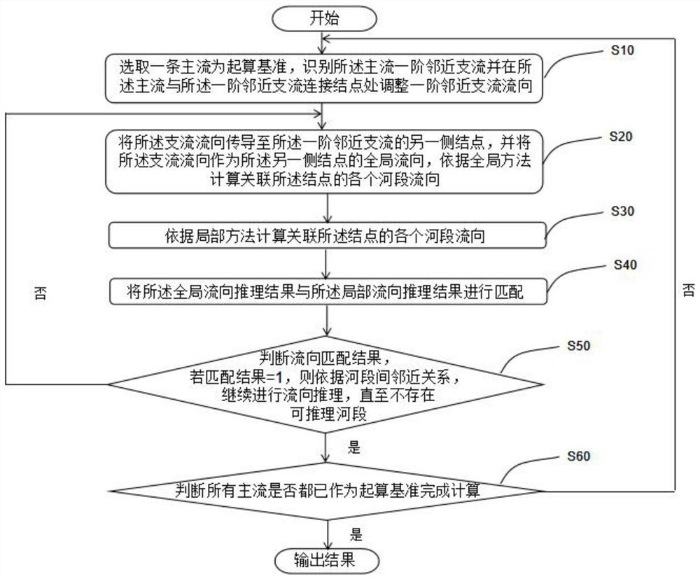
[0042] See attached figure 1 As shown, Embodiment 1 of the present invention discloses an automatic reasoning method for the flow direction of waterway bridge tributaries based on conversion nodes, including:

[0043] S10: Select a mainstream as the starting reference, identify the first-order adjacent tributary of the mainstream, and determine the flow direction of the first-order adjacent tributary according to the first conversion node of the first-order adjacent tributary. The first conversion node is the connection between the first-order adjacent tributary and the mainstream Node;

[0044]S20: Transmit the flow direction of the tributary to the second conversion node of the first-order adjacent tributary, and use the flow direction of the tributary as the global flow direction of the second conversion node, and calculate the flow direction of each river section associated with the second conversion node according to the global method, the second The conversion node is t...

Embodiment 2

[0082] Verify the method provided by Embodiment 1 of the present invention, the specific process is as follows:

[0083] 1. Experimental data and experimental environment

[0084] Relying on the WJ-III map workstation developed by the Chinese Academy of Surveying and Mapping Sciences, the automatic reasoning method for the flow direction of waterway bridges and tributaries based on the conversion nodes proposed by the present invention is embedded, and compared with the method proposed by Schwenk (2020) (hereinafter referred to as the Schwenk method) , to verify the rationality and effectiveness of the present invention. The test data are selected from the 1:10000 geographic national conditions census water system data in Yunyang County, Hubei Province, with a spatial range of 104×85km 2 , including 12 river systems and 2035 river sections, see the attached Figure 5As shown, where RN stands for RiverNetwork. The experimental environment is a single PC equipped with Windows...


PUM


Abstract

The invention discloses an automatic reasoning method for the flow direction of waterway bridges and tributaries based on conversion nodes. Firstly, two estuary and mainstream statistical identification criteria are established; Finally, with the spatial proximity relationship as a constraint, the "global" and "local" flow direction reasoning consistency judgments are carried out, and the "segmented river section" is detected to divide the bridge tributary into the mainstream, and then complete the flow direction of the tributary according to the mainstream Automatic reasoning, thereby overcoming the shortcomings of traditional methods.

Description

technical field [0001] The invention relates to the technical field of map synthesis, and more specifically relates to an automatic reasoning method for the flow direction of waterway bridges and tributaries based on conversion nodes. Background technique [0002] Waterway transportation is one of the most important modes of transportation in the field of transportation. In a large-scale transportation area, the water network structure is complex and there are many conversion nodes. Correct river flow direction is a prerequisite for rationally carrying out route space analysis and waterway transportation mapping. However, due to the large scope of the watershed or the insufficient collection of attribute information, there are often problems such as non-existence or incomplete flow directions of various waterways in the database. For a complex water network with multiple estuaries, according to the relationship with the mainstream, tributaries can be divided into two types:...

Claims


Application Information

Patent Timeline
Patent Type & Authority Patents(China)
IPC IPC(8): G06F16/29G06N5/04
CPCG06N5/04G06F16/29
Inventor 殷勇张成成张扬奇肖学福李成名戴昭鑫潘璠吴会博张伟奇李波
Owner CHINESE ACAD OF SURVEYING & MAPPING
Why Eureka
Try Eureka