Different-scale hierarchical nested simulation method for urban rainfall and flood process
A technology of urban rainfall and simulation methods, applied in special data processing applications, instruments, electrical digital data processing, etc., can solve problems that cannot meet the timeliness and accuracy of flood control and emergency response work at the same time, and improve timeliness and accuracy Effect
- Summary
- Abstract
- Description
- Claims
- Application Information
AI Technical Summary
Problems solved by technology
Method used
Image
Examples
Embodiment 1
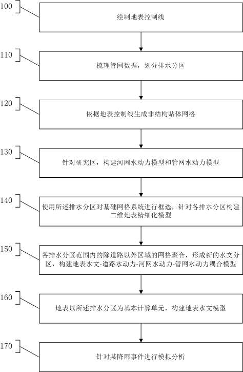
[0038] like figure 1 As shown, step 100 is executed to draw the surface control line, and draw the control line along at least one of the surface water guiding and water retaining facilities among building outlines, street edges, fences, and river embankments according to the high-resolution image.
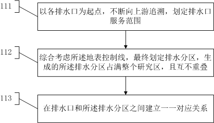
[0039] Execute step 110, sort out the pipe network data, and divide drainage zones. like figure 2 As shown, step 111 is executed, starting from each water outlet, tracing upstream continuously, and delineating the service scope of the water outlet. Execute step 112, comprehensively consider the surface control line, and finally delineate drainage partitions, and the generated drainage partitions occupy the entire research area and do not overlap each other. Step 113 is executed to establish a one-to-one correspondence between the water outlet and the water drainage area.
[0040] Execute step 120, generate a non-structure body-fitted grid according to the surface control line,...
Embodiment 2
[0047] The present invention proposes a different-scale hierarchical nested simulation method for the urban rainfall and flood process, which can effectively solve the problem of urban-scale flood analysis between "macro" and "local", "refinement requirements" and "computational efficiency" contradiction.
[0048] A hierarchical and nested simulation method of different scales for urban rainfall and flood process, the specific technical scheme is as follows.
[0049] A hierarchical and nested simulation method of different scales for urban rainfall and flood processes, comprising the following steps:
[0050] Step 1: Draw surface control lines. The specific content includes: drawing control lines along the building outlines, street edges, fences, river embankments and other surface water diversion and water retaining facilities based on high-resolution images.
[0051] Step 2: Sorting out the pipe network data, starting from each outfall, tracing upstream continuously, and d...
Embodiment 3
[0059] like Figure 4 As shown, a different-scale hierarchical nested simulation method of urban rainfall and flood process, including:
[0060] The first step: draw the surface control line;
[0061] The second step: extract the drainage partition;
[0062] Step 3: Generate the surface grid (including multiple layers) according to the control line;
[0063] Step 4: Construct the hydrodynamic model of the river network and the hydrodynamic model of the pipe network;
[0064] Step 5: Select the surface grid in the drainage area, and build a 3-level model;
[0065] Step 6: Aggregate the grids of areas other than roads within the scope of each drainage division to form a new hydrological division and build a 2-level model;
[0066] Step 7: Drainage partition is the basic calculation unit, and a level 1 model is constructed;
[0067] Step 8: Carry out simulation analysis for a rainfall event, and start the level 1, level 2 and level 3 models in sequence.
PUM
 Abstract
Description
Claims
Application Information
 - R&D
- Intellectual Property
- Life Sciences
- Materials
- Tech Scout
- Unparalleled Data Quality
- Higher Quality Content
- 60% Fewer Hallucinations
Browse by: Latest US Patents, China's latest patents, Technical Efficacy Thesaurus, Application Domain, Technology Topic, Popular Technical Reports.
© 2025 PatSnap. All rights reserved.Legal|Privacy policy|Modern Slavery Act Transparency Statement|Sitemap|About US| Contact US: help@patsnap.com


