Brain-like relative navigation method based on social location cells/grid cells

A technology of grid cells and relative navigation, applied to biological neural network models, complex mathematical operations, instruments, etc., can solve problems such as poor robustness and inaccurate calculations, and achieve improved robustness, strong universality, and The effect of learnability

Pending Publication Date: 2021-08-24
NANJING UNIV OF AERONAUTICS & ASTRONAUTICS
View PDF0 Cites 1 Cited by
  • Summary
  • Abstract
  • Description
  • Claims
  • Application Information

AI Technical Summary

Problems solved by technology

[0006] In order to solve the problem of poor robustness and inaccurate calculations in the existing relative navigation method of swarm drones in the com

Method used


Image

  • Brain-like relative navigation method based on social location cells/grid cells
  • Brain-like relative navigation method based on social location cells/grid cells
  • Brain-like relative navigation method based on social location cells/grid cells

Examples


specific Embodiment approach

[0075] The vision processing module receives the images collected by the drone's visual sensor in real time, and calculates the linear velocity and heading angle of the drone in the forward and height directions according to the pixel value changes of two adjacent frames of images.

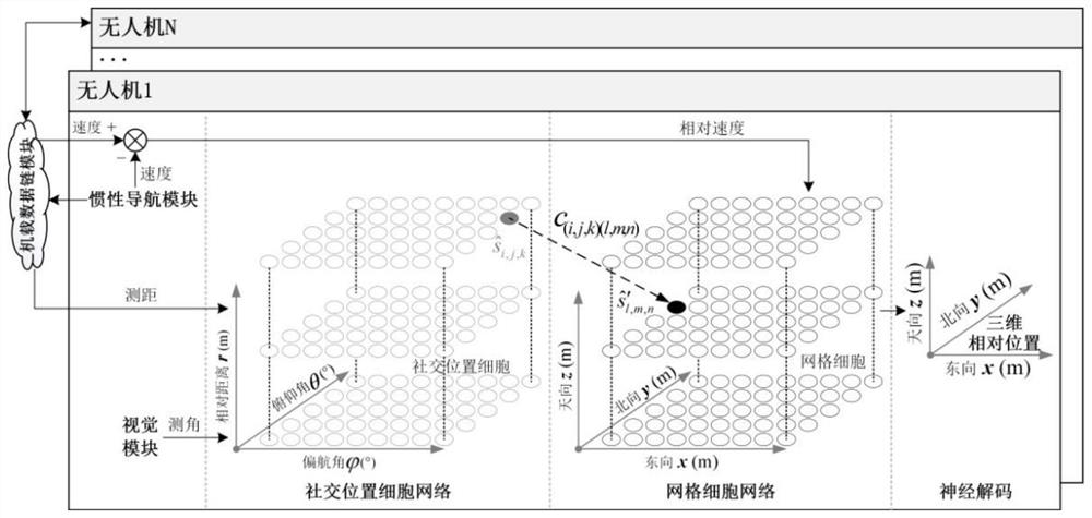
[0076] 1. Obtain UAV relative navigation sensor information

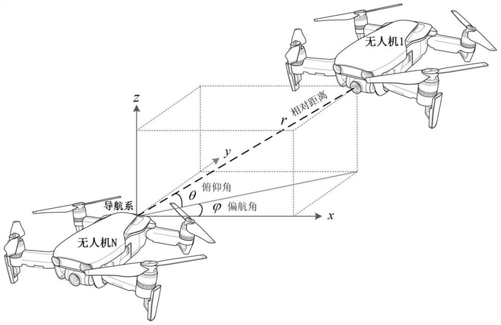
[0077] Load inertial navigation module, vision module, and airborne data link module for each UAV in the cluster, such as figure 2 As shown, the visual module outputs the relative pitch angle and relative yaw angle of the UAV relative to another UAV; the inertial navigation module outputs the three-dimensional velocity of the UAV in the geographic coordinate system; the airborne data link The module receives the three-dimensional velocity of another UAV in the geographic coordinate system output from the inertial navigation module of another UAV, and the relative distance between the UAV and the other UAV.

[0078] 2. Construct a 3D m...


PUM


Abstract

The invention relates to a brain-like relative navigation method based on social location cells/grid cells, and belongs to the field of cluster unmanned aerial vehicle intelligent navigation. According to the method, the relative positions of companions and the relative motor nervous mechanism of sensitive companions of a grid cell network are sensed by referring to a social position cell network of a hippocampal region of a bat. Firstly, a grid cell network model is constructed based on an attractor network to calculate endogenous relative position information between the unmanned aerial vehicles, and then a social contact position cell network model is constructed by using an isotropic Gaussian function to calculate exogenous relative position information between the unmanned aerial vehicles. Finally, the endogenous and exogenous relative position information are fused through a synaptic correlation learning algorithm to obtain relative position information between the unmanned aerial vehicles. The invention provides the brain-like relative navigation method which does not need linearization, is high in original signal fidelity, is learnable in architecture and is high in universality, and can be used for intelligent autonomous relative navigation of the cluster unmanned aerial vehicle in a satellite denial complex environment.

Description

technical field [0001] The invention relates to a brain-like relative navigation method based on social position cells / grid cells, and belongs to the field of intelligent navigation of cluster drones. Background technique [0002] Swarm UAV is a kind of reconfigurable, on-demand design, distributed network system formed by a certain number of UAV individuals through a specific cluster mechanism. Man-machines have significantly enhanced task execution capabilities, flexibility and robustness, and have broad application prospects in military and civilian fields such as reconnaissance, search and rescue, group light show performances, and surveying and mapping. [0003] Accurate and reliable relative navigation information is the premise and basis for ensuring the smooth flight and operation of UAV clusters. At present, cluster UAVs mainly use the Extended Kalman Filter (EKF) algorithm based on inertial / visual angle measurement / radio ranging information for relative navigation...

Claims


Application Information

Patent Timeline
IPC IPC(8): G06F16/9536G06F16/9537G06F17/16G06N3/06G06Q50/00
CPCG06F17/16G06N3/061G06Q50/01G06F16/9536G06F16/9537
Inventor 杨闯熊智刘建业华冰晁丽君陈雨荻王雅婷戴嘉伟
Owner NANJING UNIV OF AERONAUTICS & ASTRONAUTICS
Why Eureka
Try Eureka