Scale adaptive visual field analysis method

A scale-adaptive, domain analysis technology, applied in ICT adaptation, climate sustainability, instrumentation, etc., which can solve problems such as poor operating experience, difficulty in functioning, and reduced accuracy

Active Publication Date: 2021-08-27
NANJING UNIV OF POSTS & TELECOMM
View PDF1 Cites 7 Cited by
  • Summary
  • Abstract
  • Description
  • Claims
  • Application Information

AI Technical Summary

Problems solved by technology

This type of algorithm is also an approximate algorithm, and the time complexity is O(r 2 ), the accuracy decreases
[0007] The improved algorithm of the above algorithm has improved the efficiency to a certain extent at the cost of loss of precision, or adopted parallelization to improve the calculation speed, but it is difficult to play a role under the limitation of hardware or network, and the user's operating experience becomes worse.

Method used


Image

  • Scale adaptive visual field analysis method
  • Scale adaptive visual field analysis method
  • Scale adaptive visual field analysis method

Examples


Embodiment 1

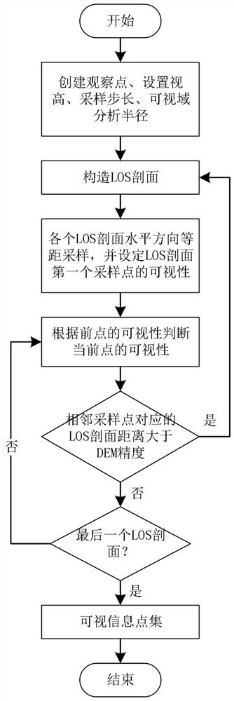
[0061] Such as figure 1 Shown is an algorithm flow chart of a scale-adaptive visual domain analysis method, including:

[0062] Step A: Obtain a regular grid DEM (Digital Elevation Model, Digital Elevation Model), and create observation points and set various parameters on the regular grid DEM; specifically include:

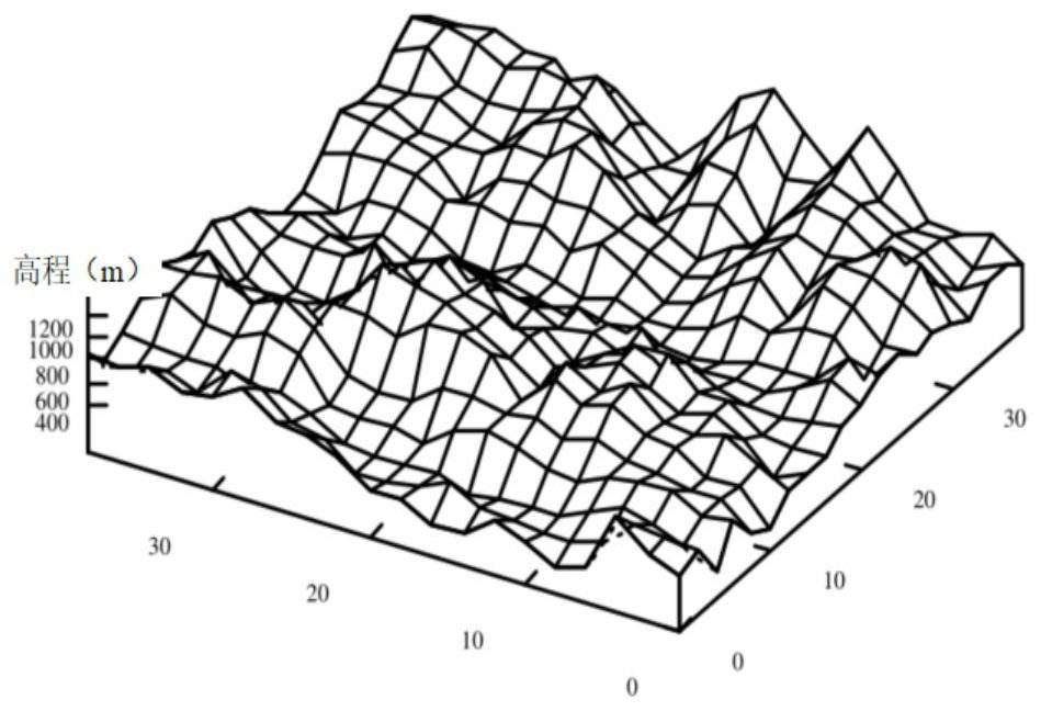
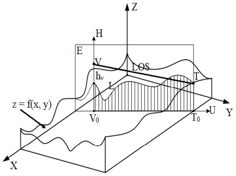
[0063] The regular grid DEM can be imported through the data, or can be downloaded from the official website of Tianditu, such as figure 2 As shown, each cell or grid of DEM grid terrain has an (x, y) coordinate and height value. Such as image 3 As shown, the observation point V is selected on the DEM grid to simulate the human eye, and the vertical distance from point V to the surface is the apparent height h v , the projection of point V on the XY plane is point V 0 , a point at the edge of the terrain is point T, and its projection on the XY plane is point T 0 , on the U axis, the point V 0 to point T 0 The distance is the visual analysis radius. In ...


PUM


Abstract

The invention discloses a scale adaptive visual field analysis method, which comprises the following steps of: judging the visibility of a current point by adopting an effective multiplexing strategy in a continuous terrain on an LOS terrain section and utilizing the visibility of a front point through continuity and alternation of a visual area and an invisible area on the LOS terrain section to obtain the visibility of each sampling point on the terrain section, reducing a large amount of calculation redundancy, and well improving the efficiency of an algorithm; constructing a plurality of profiles in a visual analysis area, and when the distance between LOS terrain profiles exceeds the DEM precision, adding new profile terrain analysis, so that the sampling precision of visual range analysis is improved. According to the invention, the calculation efficiency of visual field analysis is greatly improved, and efficient terrain visual field analysis can be carried out under the condition of large-scale data.

Description

technical field [0001] The invention belongs to the technical field of terrain space analysis, and in particular relates to a scale-adaptive visual domain analysis method. Background technique [0002] Viewshed Analysis is an important part of terrain analysis, and an indispensable function in the spatial analysis of geographic information systems, that is, on the digital terrain based on DEM data, select a specific position to simulate human Eye, get the spatial occlusion relationship of a certain area, and make accurate visual judgments. In the civil field, the visual field analysis can be used for architectural planning, path planning, viewing point location selection, communication or TV base station location selection, etc.; Marching route planning, etc. [0003] For the viewshed analysis, Lu Min et al. summarized and compared some common calculation methods of terrain viewsheds (Lu Min et al. DEM-based viewshed analysis and calculation [J]. Computer Simulation, 2006(...

Claims


Application Information

Patent Timeline
Patent Type & Authority Applications(China)
IPC IPC(8): G06T17/05
CPCG06T17/05Y02A90/10
Inventor 胡栋林强张庆军
Owner NANJING UNIV OF POSTS & TELECOMM
Why Eureka
Try Eureka