Unmanned aerial vehicle searching method for underground multi-branch cave

A UAV, multi-branch technology, applied in the field of UAV exploration, can solve the problems of insufficient endurance, difficulty in large-scale exploration, and inability to develop the agility of small flying robots, so as to improve the exploration rate and safety. Effect

Active Publication Date: 2021-09-07
TONGJI UNIV
View PDF17 Cites 2 Cited by
  • Summary
  • Abstract
  • Description
  • Claims
  • Application Information

AI Technical Summary

Problems solved by technology

[0004] However, the current autonomous exploration of UAVs is very limited. Generally, a low-speed conservative strategy is adopted to ensure the safe navigation of UAVs. At the same time, the flight path of subsequent UAVs is optimized based on real-time airborne positioning and composition functions.
Due to the limited battery life of UAVs, the endurance is insufficient, and low-speed exploration cannot develop the full agility of small flying robots, making large-scale exploration difficult.
On the other hand, the autonomous path planning and exploration strategy of UAVs in unknown multi-branch tunnel environments remains to be studied

Method used


Image

  • Unmanned aerial vehicle searching method for underground multi-branch cave
  • Unmanned aerial vehicle searching method for underground multi-branch cave
  • Unmanned aerial vehicle searching method for underground multi-branch cave

Examples


Embodiment 1

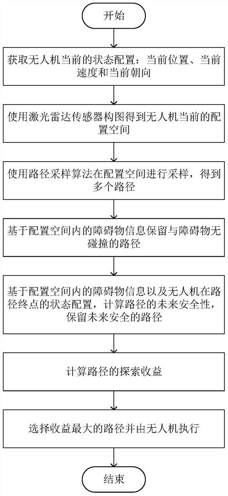
[0039] A drone exploration method for underground multi-branched caves, such as figure 1 shown, including the following steps:

[0040] S1. Obtain the current state configuration of the drone, including the current position, current speed and current orientation, and use the laser radar sensor to obtain the current configuration space of the drone. The configuration space is the area to be explored in front of the drone;

[0041] The UAV is a four-rotor aircraft that can explore and fly autonomously in the tunnel. It is equipped with a lidar sensor and processor, and the battery is a single lithium battery. Using the lidar sensor, using the real-time composition and positioning method, the current configuration space is obtained. The map representation method used is a volume map based on the truncated symbolic distance field (TSDF), and the Euclidean symbolic distance field is used to represent the UAV and obstacles. the distance of the object. Given the limited onboard com...


PUM


Abstract

The invention relates to an unmanned aerial vehicle searching method for an underground multi-branch cave. The method comprises the steps that the current state configuration of an unmanned aerial vehicle is acquired, and the current configuration space of the unmanned aerial vehicle is acquired through a laser radar sensor; sampling is carried out in the configuration space by using a path sampling algorithm to obtain a plurality of paths of the unmanned aerial vehicle in the configuration space, and a collision-free path are reserved; the future safety of each path is calculated according to the state configuration and configuration space of the unmanned aerial vehicle at the path end point, and the future safe path is reserved; the exploration income of each path is calculated, and the unmanned aerial vehicle executes the path with the maximum exploration income. Compared with the prior art, the method has the advantages that a plurality of paths are firstly acquired, the collision-free path and the future safe path are reserved in combination with obstacle information of the configuration space, and then the path with the highest income is selected, so that autonomous exploration of the unmanned aerial vehicle in an unknown multi-branch tunnel environment can be realized at a relatively high speed, and the unmanned aerial vehicle with limited cruising ability can carry out exploration in a larger range and a farther path.

Description

technical field [0001] The invention relates to an unmanned aerial vehicle exploration method, in particular to an unmanned aerial vehicle exploration method for underground multi-branched caves. Background technique [0002] With the development of the economy, the construction of infrastructure such as urban construction, bridges and tunnels is also developing by leaps and bounds. At present, a large part of tunnels and underground works have entered the "old" period, requiring regular inspection and maintenance, and lack of proper maintenance may lead to catastrophic consequences such as structural damage. Traditional investigation techniques include building supports along the entire structure, or using ground vehicles to cooperate with manual investigation work, but these methods have problems such as high risk factor, heavy workload, harsh working environment, and intensive labor costs. Therefore, using new technologies to develop a A fast and efficient method for det...

Claims


Application Information

Patent Timeline
IPC IPC(8): G05D1/08G05D1/10
CPCG05D1/0808G05D1/106
Inventor 何斌李丰沈润杰李刚陆萍朱忠攀
Owner TONGJI UNIV
Why Eureka
Try Eureka