A fully automatic topographic map surveying and mapping device and its surveying and mapping method

A topographic map, fully automatic technology, applied in the field of topographic map surveying and mapping, can solve the problems of loose and damaged internal parts of drones, no lens cleaning mechanism, etc., to achieve the effect of improving service life and reducing energy consumption

Active Publication Date: 2022-06-24
济南市勘察测绘研究院
View PDF0 Cites 0 Cited by
  • Summary
  • Abstract
  • Description
  • Claims
  • Application Information

AI Technical Summary

Problems solved by technology

[0004] The invention solves the problem that the UAV has no shock-absorbing buffer mechanism. When it crashes, it will directly contact the ground, which may easily cause loosening and damage to the internal parts of the UAV. At the same time, it also solves the problem that the existing surveying and mapping UAV does not have lens cleaning. Institutional Technical Issues

Method used


Image

  • A fully automatic topographic map surveying and mapping device and its surveying and mapping method
  • A fully automatic topographic map surveying and mapping device and its surveying and mapping method
  • A fully automatic topographic map surveying and mapping device and its surveying and mapping method

Examples


Embodiment Construction

[0026] The technical solutions in the embodiments of the present invention will be clearly and completely described below with reference to the accompanying drawings in the embodiments of the present invention. Obviously, the described embodiments are only a part of the embodiments of the present invention, rather than all the embodiments. Based on the embodiments of the present invention, all other embodiments obtained by those of ordinary skill in the art without creative efforts shall fall within the protection scope of the present invention.

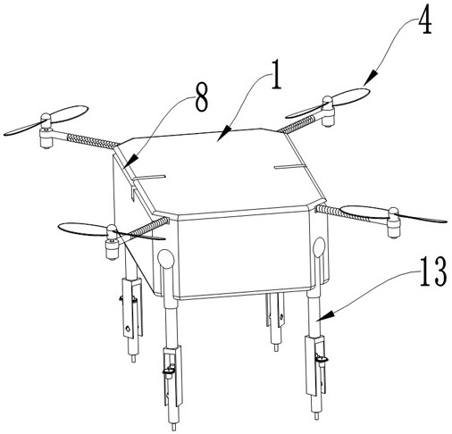
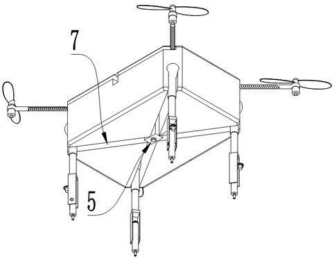
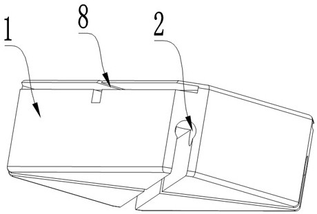
[0027] like Figure 1-9As shown in the figure, a fully automatic topographic mapping equipment includes a main body 1, a control module, an image processing module, a fault detection module, a Beidou navigation and positioning system, and a distance sensor for measuring the height from the ground. The main body 1 is provided with an arc-shaped groove 2. The side wall of the main body 1 is connected with a spiral blade 4 through the f...


PUM


Abstract

The invention belongs to the technical field of topographic map surveying and mapping, and discloses a fully automatic topographic map surveying and mapping device and its surveying and mapping method. Distance sensor, the body is provided with an arc groove, the side wall of the body is connected with a spiral blade through a folding mechanism, the bottom of the body is provided with a camera surveying and mapping module, and a movable ball is movably connected in the arc groove, and the arc The inner wall of the arc-shaped groove is provided with a first groove, and the top wall of the arc-shaped groove is provided with a second groove; the first motor is arranged in the first groove, and the present invention solves the problem that the drone does not have shock absorption. The buffer mechanism will directly contact the ground when it crashes, which will easily lead to loosening and damage to the internal parts of the drone. It also solves the technical problem that the existing surveying and mapping drones do not have a lens cleaning mechanism.

Description

technical field [0001] The invention belongs to the technical field of topographic map surveying and mapping, in particular to an automatic topographic map surveying and mapping device and a surveying and mapping method. Background technique [0002] Surveying is all about measuring and drawing. Based on computer technology, optoelectronic technology, network communication technology, space science, and information science, with global navigation satellite positioning system, remote sensing, and geographic information system as the core technology, the existing feature points and boundaries on the ground are obtained through measurement methods to reflect the ground. The current graphics and location information are used for the planning and design and administrative management of engineering construction. The surveying and mapping methods include ordinary surveying and photogrammetry. [0003] In topographic mapping, drones are usually used for mapping to improve the effic...

Claims


Application Information

Patent Timeline
Patent Type & Authority Patents(China)
IPC IPC(8): B64C27/08B64C27/52B64D45/00B64D47/08B64C25/24B64C25/12B64C1/30B08B1/04G01C7/04
CPCB64C27/08B64D45/00B64D47/08B64C25/12B64C25/24B64C1/30G01C7/04B64C27/52B08B1/04B64U10/10B64U2101/30
Inventor 赵向阳张兴国赵云黄福生
Owner 济南市勘察测绘研究院
Why Eureka
Try Eureka