Supercharge Your Innovation With Domain-Expert AI Agents!

Positioning and navigation method and system for unmanned driving system

A technology of positioning, navigation and unmanned driving, which is applied in the field of positioning, navigation and system of unmanned driving systems, and can solve problems such as poor positioning effect.

Pending Publication Date: 2021-09-10
ZHENGZHOU YUTONG BUS CO LTD
View PDF6 Cites 0 Cited by
  • Summary
  • Abstract
  • Description
  • Claims
  • Application Information

AI Technical Summary

Problems solved by technology

[0008] The purpose of the present invention is to provide a positioning and navigation method and system for an unmanned driving system to solve the problem of poor positioning effect in the current vehicle navigation process

Method used


Image

  • Positioning and navigation method and system for unmanned driving system
  • Positioning and navigation method and system for unmanned driving system
  • Positioning and navigation method and system for unmanned driving system

Examples


Embodiment Construction

[0022] In order to make the object, technical solution and advantages of the present invention clearer, the present invention will be further described in detail below in conjunction with the accompanying drawings and examples, but the embodiments of the present invention are not limited thereto.
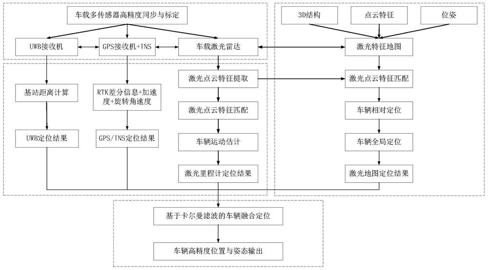
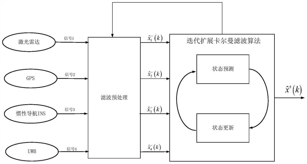
[0023] The technical idea of ​​the present invention: propose a scheme based on the fusion of lidar data, GPS / INS data and UWB data, solve the time-space synchronization problem of four kinds of sensor data through high-precision calibration, based on GPS / INS positioning results, UWB positioning results , laser feature map positioning results, and laser odometer positioning results, to achieve high-precision and high-stability positioning of the unmanned driving system in blind spots and all-weather environments.

[0024] Embodiment of positioning navigation method:

[0025] The positioning process of multi-sensor position data fusion is as follows: figure 1 Shown:

[0026] Step 1...


PUM


Abstract

The invention relates to a positioning and navigation method and system for an unmanned driving system. The method comprises the steps of (1) obtaining road position data through a laser radar, a GPS receiver, a vehicle-mounted INS and a UWB receiver, and recording the data as laser radar data, GPS data, INS data and UWB data; (2) judging whether the GPS receiver is shielded or not, the real-time weather condition and the distance between the UWB receiver and the positioning base station; and (3) if the GPS receiver is shielded, the real-time weather is bad or the distance between the UWB receiver and the positioning base station exceeds a set range, fusing the positioning results obtained by different positioning modes to serve as a final positioning result. According to the positioning and navigation method, high-precision stable positioning of the unmanned driving system in a blind area environment and an all-weather environment can be realized.

Description

technical field [0001] The invention relates to a positioning and navigation method and system for an unmanned driving system. Background technique [0002] The purpose of positioning is to allow unmanned vehicles to find their own exact location. It can be said that positioning and navigation technology is the core of the entire unmanned driving technology. Currently, commonly used positioning technologies include laser SLAM positioning technology, GPS / INS positioning technology and UWB positioning. technology. [0003] For an unmanned vehicle equipped with multi-line lidar, it is required to be able to move freely in the real environment, so it is necessary to recognize the surrounding environment and know its position in the environment, and this is exactly It is a problem that LiDAR real-time positioning and mapping technology (Simultaneous Localization and Mapping, SLAM) needs to deal with. Laser SLAM technology involves a wide range of fields. In different usage scen...

Claims


Application Information

Patent Timeline
Patent Type & Authority Applications(China)
IPC IPC(8): G01C21/16G01C21/34G01S19/47
CPCG01C21/165G01C21/3415G01S19/47
Inventor 黄琨苏常军陈慧勇李高鹏
Owner ZHENGZHOU YUTONG BUS CO LTD
Features
  • R&D
  • Intellectual Property
  • Life Sciences
  • Materials
  • Tech Scout
  • Unparalleled Data Quality
  • Higher Quality Content
  • 60% Fewer Hallucinations
Learn More