Map lane information updating method and system based on unmanned aerial vehicle

An information update, drone technology, applied in the field of drones, can solve problems such as low efficiency

Pending Publication Date: 2021-09-28
CHENGDU JOUAV AUTOMATION TECH
View PDF12 Cites 5 Cited by
  • Summary
  • Abstract
  • Description
  • Claims
  • Application Information

AI Technical Summary

Problems solved by technology

[0005] In view of this, the present invention provides a UAV-based map lane information update method and its system, which solves the problem of low efficiency in the existing map lane information update method by improving the information detection and update method

Method used


Image

  • Map lane information updating method and system based on unmanned aerial vehicle
  • Map lane information updating method and system based on unmanned aerial vehicle
  • Map lane information updating method and system based on unmanned aerial vehicle

Examples


Embodiment Construction

[0020] In order to enable those skilled in the art to better understand the technical solutions of the present invention, the present invention will be further described in detail below in conjunction with the accompanying drawings and specific embodiments.

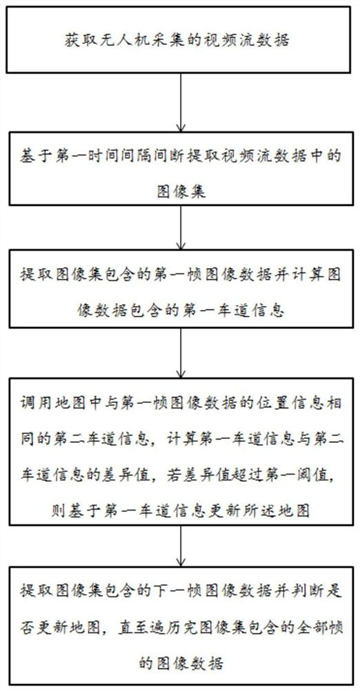
[0021] Such as figure 1 As shown, a UAV-based map lane information update method is characterized in that it includes: obtaining video stream data collected by the UAV; intermittently extracting image sets in the video stream data based on the first time interval; extracting The first frame of image data contained in the image set and calculate the first lane information contained in the image data; call the second lane information in the map that is the same as the position information of the first frame of image data, and calculate the first lane information The difference value between the lane information and the second lane information, if the difference value exceeds a first threshold, update the map based on the fi...


PUM


Abstract

The invention discloses a map lane information updating method and system based on an unmanned aerial vehicle. The method comprises the following steps: acquiring video stream data acquired by the unmanned aerial vehicle; intermittently extracting an image set in the video stream data based on a first time interval; extracting first frame image data contained in the image set and calculating first lane information contained in the image data; calling second lane information which is the same as the position information of the first frame of image data in a map, calculating a difference value between the first lane information and the second lane information, and if the difference value exceeds a first threshold value, updating the map based on the first lane information; and extracting the next frame of image data contained in the image set and judging whether the map is updated or not until all frames of image data contained in the image set are traversed.

Description

technical field [0001] The invention relates to the technical field of drones, in particular to a method and system for updating map lane information based on drones. Background technique [0002] As an electronic map with higher precision and more data dimensions, high-precision maps are more and more widely used in transportation fields such as vehicles with the development of science and technology. High-precision maps store a large amount of driving assistance information as structured data, such as lane lines, central dividers, sidewalks, arrows, and road edges. [0003] Traditional high-precision map update methods include: using surveying and mapping vehicles to collect laser point cloud data, and then manually extracting traffic elements; extracting traffic elements based on 3D point cloud data collected by drones. However, the scheme operation method based on the measuring vehicle is inefficient, and the technical scheme processing process based on the UAV point cl...

Claims


Application Information

Patent Timeline
Patent Type & Authority Applications(China)
IPC IPC(8): G06K9/00G06K9/62G06N3/08G06F16/23G06F16/29
CPCG06N3/08G06F16/29G06F16/23G06F18/214
Inventor 蒋友妮曹治锦余毅
Owner CHENGDU JOUAV AUTOMATION TECH
Why Eureka
Try Eureka