Navigation method and device, electronic equipment and storage medium

A navigation method and navigation path technology, applied in the field of navigation, can solve the problems of difficulty in meeting the requirements of flexibility, high maintenance cost, very sensitive to landmark pollution and mechanical wear, etc., and achieve the effect of reducing environmental dependence and accurate positioning.

Pending Publication Date: 2021-10-01
ZHEJIANG UNIVIEW TECH CO LTD
View PDF0 Cites 0 Cited by
  • Summary
  • Abstract
  • Description
  • Claims
  • Application Information

AI Technical Summary

Problems solved by technology

The above-mentioned guidance method based on ground beacons is easy to implement in small scenarios, but it is highly dependent on the environment, very sensitive to landmark pollution and mechanical wear, general reliability, complex environment layout, difficult to meet the requirements of flexibility, and high maintenance costs

Method used


Image

  • Navigation method and device, electronic equipment and storage medium
  • Navigation method and device, electronic equipment and storage medium
  • Navigation method and device, electronic equipment and storage medium

Examples


Embodiment Construction

[0052] The following will clearly and completely describe the technical solutions in the embodiments of the application with reference to the drawings in the embodiments of the application. Apparently, the described embodiments are only some of the embodiments of the application, not all of them. Based on the embodiments in this application, all other embodiments obtained by persons of ordinary skill in the art without creative efforts fall within the protection scope of this application.

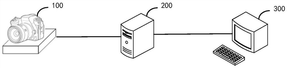
[0053] In order to facilitate the understanding of the navigation method provided by the present application, the system used by it is introduced below. see figure 1 , which shows an architecture diagram of a navigation system provided by an embodiment of the present application, such as figure 1 As shown, it includes a mobile platform device 100 , a processor 200 and a client 300 .

[0054] Wherein, the mobile platform device 100 is equipped with a monocular image acquisition device, mov...


PUM


Abstract

The invention discloses a navigation method and device, electronic equipment and a computer readable storage medium. The method comprises the steps of: determining a world coordinate system based on an ArUco code in a target environment, and building a three-dimensional point cloud picture corresponding to the target environment according to the three-dimensional coordinate of each ORB feature point in the world coordinate system, wherein the plurality of ArUco codes are distributed at any position of a target environment; acquiring a current image acquired by image acquisition equipment, and determining an absolute pose of the image acquisition equipment in the world coordinate system according to the ORB feature points in the current image; and acquiring a navigation path, determining a target ORB feature point belonging to the navigation path in the current image, and performing navigation based on the current three-dimensional coordinate of the image acquisition equipment in the world coordinate system, the absolute pose and the three-dimensional coordinate of the target ORB feature point. According to the navigation method provided by the invention, stable and reliable autonomous positioning and navigation can be realized, and the environmental dependence of navigation can be reduced.

Description

technical field [0001] The present application relates to the technical field of navigation, and more specifically, to a navigation method, device, electronic equipment, and computer-readable storage medium. Background technique [0002] The visual positioning and navigation method using image acquisition equipment as the main sensor is an important method for mobile platform equipment such as mobile robots and drones to achieve autonomous positioning and navigation. The image data captured by the image acquisition device contains rich scene information. Through image processing and computer vision technology, the real-time pose estimation of the image acquisition device in three-dimensional space can be realized, thereby providing accurate position and orientation information for the mobile platform. [0003] In related technologies, guide lines of different colors are laid on the ground, ground beacons such as barcodes or QR codes are laid out, and positioning and navigati...

Claims


Application Information

Patent Timeline
Patent Type & Authority Applications(China)
IPC IPC(8): G01C21/20
CPCG01C21/20
Inventor 李旭杰
Owner ZHEJIANG UNIVIEW TECH CO LTD
Why Eureka
Try Eureka