Immersive navigation system for augmented reality and satellite positioning based on mobile terminal

An augmented reality, navigation system technology, applied in the field of navigation, can solve problems such as difficulty in finding target buildings, and achieve the effect of high-precision indoor positioning

Pending Publication Date: 2021-10-08
NAT UNIV OF DEFENSE TECH
View PDF8 Cites 0 Cited by
  • Summary
  • Abstract
  • Description
  • Claims
  • Application Information

AI Technical Summary

Problems solved by technology

Solve the problem that it is difficult for users to find the target building during navigation, and effectively make up for the shortcomings of traditional navigation methods

Method used


Image

  • Immersive navigation system for augmented reality and satellite positioning based on mobile terminal
  • Immersive navigation system for augmented reality and satellite positioning based on mobile terminal
  • Immersive navigation system for augmented reality and satellite positioning based on mobile terminal

Examples


Embodiment 1

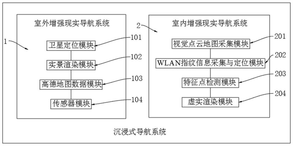
[0042] Please refer to Figure 1-9 As shown, the immersive navigation system based on mobile terminal augmented reality and satellite positioning includes:

[0043] Outdoor augmented reality navigation system 1. The outdoor augmented reality navigation system 1 first obtains user positioning information, and fuses the attitude data of the user equipment with AutoNavi data, and then superimposes the virtual navigation information with the real scene.

[0044] Indoor augmented reality navigation system 2. Indoor augmented reality navigation system 2 establishes a visual point cloud map and WiFi fingerprint recognition library, and calculates the position and attitude information of the user equipment, and integrates virtual navigation information with video stream images in real time to display the virtual reality fusion. navigation information.

[0045] The outdoor augmented reality navigation system 1 includes a satellite positioning module 101 and a real scene rendering modu...

Embodiment 2

[0101] On the basis of Embodiment 1, the indoor augmented reality navigation system 2 includes a visual point cloud map collection module 201 and a WLAN fingerprint information collection and positioning module 202, wherein,

[0102] The visual point cloud map collection module 201 is used for real-time collection of indoor environment information to establish an indoor visual map.

[0103] The WLAN fingerprint information collection and positioning module 202 establishes a fingerprint identification database by collecting fingerprint information, and the WLAN fingerprint information collection and positioning module 202 is electrically connected to the visual point cloud map collection module 201 .

[0104] The indoor augmented reality navigation system 2 also includes a feature point detection module 203 and a virtual-real rendering module 204, wherein,

[0105]The feature point detection module 203 is used to select the visual difference points in the image, and track and u...


PUM


Abstract

The invention relates to the technical field of navigation, in particular to an immersive navigation system of a mobile terminal based on augmented reality and satellite positioning . The system comprises an outdoor augmented reality navigation system and an indoor augmented reality navigation system. In an outdoor environment, the system converts a satellite positioning coordinate and a point-of-interest coordinate into a virtual coordinate, and finally puts a virtual road sign and a virtual route on a real road by using an augmented reality technology, thereby achieving an effect of virtual-real fusion. In an indoor environment, the system integrates indoor map information acquisition, indoor navigation positioning and augmented reality navigation functions, regional positioning is realized by using a WiFi fingerprint matching positioning algorithm, and high-precision indoor positioning is realized by combining a visual matching positioning method.

Description

technical field [0001] The invention relates to the technical field of navigation, in particular to an immersive navigation system based on mobile terminal augmented reality and satellite positioning. Background technique [0002] With the rapid development of the Internet and smart phones, location-based services are becoming more and more popular, and the demand for navigation is also increasing. In recent years, with the rapid development of AR technology, the combination of augmented reality technology and location-based services (LBS) has become a research hotspot. Using augmented reality technology, users can travel in an intuitive way of navigation, which greatly improves the efficiency of navigation. Solve the problem that users find it difficult to find the target building during navigation, and effectively make up for the shortcomings of traditional navigation methods. Contents of the invention [0003] In view of the above-mentioned shortcomings existing in th...

Claims


Application Information

Patent Timeline
Patent Type & Authority Applications(China)
IPC IPC(8): G01S19/45G01S19/46G01S19/47G01C21/28
CPCG01S19/45G01S19/46G01S19/47G01C21/28
Inventor 士涛刘琦王茂松
Owner NAT UNIV OF DEFENSE TECH
Why Eureka
Try Eureka